Quantcast
Channel: Jim & Carole's Mexico Adventure
Viewing all 346 articles
Browse latest View live

Hiking the Rio Caliente in the Bosque de la Primavera Wilderness

$
0
0
Traversing the Rio Caliente, one of many crossings we made that day. A few months ago, I joined a group of other hikers to visit the Rio Caliente area of the Bosque de la Primavera (Forest of the Spring), a huge natural preserve next to Guadalajara. I have visited various sections of the Bosque over the years and each visit has been unique. The areas have been so different from one another that I could almost believe that I was in a different part of the state each time. One reason for this is the size of the Bosque de la Primavera. At 30,500 hectares (75,367 acres), it nearly equals huge, sprawling Guadalajara itself. For a Google map showing the forest and its cheek-by-jowl relationship with the city, click here.


Our hiking group was almost as varied as the different parts of the Bosque. Our international set of hikers totalled eleven: six from the US, four  Canadians, and one Brit. Although Abela, seen above in the lead, is Canadian, I believe she is a Filipina who immigrated. The group included nine men and two women, all experienced hikers. In addition to the human contingent, I should also mention that two of our most enthusiastic hikers were dogs: Levi and Matty.


Levi never misses a hike if Larry, his dog-dad, comes along. Possessing one of the most beautiful coats I have ever seen on a collie, Levi wins the admiration of everyone he encounters. He is still a young dog, but that gives him the energy to cover several times the ground that human hikers do on the same trek. As you can see, the hike took place in early spring, a very dry season when much of the vegetation is rusty brown in color. Except for the evergreens, only those plants close to water sources show any green.


Small concrete dams create shallow pools at various points along the river. The spillway along the left bank has resulted in a waterfall. The Rio Caliente runs through a winding valley with steep bluffs on either side. The bluffs rise to a broad rolling plateau. The Bosque de la Primavera is roughly oval in shape. It is essentially a huge, heavily-forested and steep-sided plateau made up of ancient lava. The top area is covered with ridges and volcanic craters and these, in turn, are blanketed with forests of oak and pine. These forests have been described as "the lungs of Guadalajara." Water has cut through the soft tufa soil, creating deep, sheer-sided ravines with streams along the bottoms. In some areas, residual vulcanism has resulted in hot springs. It is from these sources of boiling water that Rio Caliente (Hot River) gets its name.  For a satellite view of the river area, click here.


Eileen leaps across the top of a waterfall while Abela waits her turn. With her long legs, the jump is a piece of cake for Eileen. Not so much for petite Abela.  While the river is nowhere very deep, care must be taken to avoid a twisted ankle or worse. A sturdy hiking stick like that carried by Abela can provide a vital third point of balance.


After leaping the waterfall, we proceed up a deep arroyo. Gary (left) Chuck (center) and Paul (right) move through dry grass and light undergrowth as they pick their way along a faint path. The green undergrowth in the center-right of the photo tracks a stream of hot water originating further up the arroyo. The Bosque is a rather odd amalgam of federal and state jurisdictions, with a patchwork of private ownership mixed into it. There were attempts back in the 1960s and 70s to open it to large-scale real estate development, but fortunately these were resisted.


A hot waterfall tumbled down from above. The further up the arroyo we moved, the hotter the water. Fortunately, the morning was still cool so the experience was quite pleasant.


The deeper we got into the arroyo, the more steeply the sides rose on either side. If you look closely, you can see a bit of steam rising from the rushing water. The cliffs toward the end of the cut rose at least a couple of hundred feet above us.


Jim B takes a break beside a hot pool. He looked to me like a big leprechaun wielding an over-sized  magic wand. Jim has become the de facto leader of the hikers that set out from Donas Donuts in Ajijic every Tuesday and Friday morning. Each month, he emails out a list of proposed hikes. While many of these are very challenging even for the more experienced folks, he often suggests alternate routes for those with more leisurely inclinations. Challenging or not, Jim's hikes are always interesting and often spectacular.


Lush vegetation grows on the creek bottom, encouraged by the hot, mineral-rich water. Long filmy tendrils of emerald-green plants wave in the swift current. At this point, the water is hot to the touch.


Steam rises from the stream bed as we near the source of the boiling water. I wouldn't care to stick my bare foot into this water. Here, the trail turned up the hill, so we never encountered the  spring where the hot water emerges from the head of the arroyo. Perhaps next time.


Abela takes a breather. The trail becomes quite steep at this point. Huge leaves from the surrounding oak forest filled the depression of the trail bed. We had to step carefully to avoid tripping over large, hidden rocks. In the background, you can see the sheer cliffs surrounding the head of the arroyo.


Up, up, and more up. The surrounding oak trees were sparse enough that we could see our goal: the top of the ridge. I have always found that a stiff climb is easier if I can see the end of it, and thus measure my progress.


Jacques perches on a handy boulder beside the trail. Jacques, a Canadian, is a "snow bird" who comes down every winter. He returned to the still-snowy north shortly after this hike. One of the stronger and more adventurous hikers among us, Jacque is always ready to pioneer a new route.


The top of the plateau is covered with an open pine forest. Having reached the top, we found a deep layer of large, rust-hued, pine needles underfoot. Having walked over many a rocky trail, they formed a pleasant cushion beneath my boots. There is very little undergrowth on the plateau and the trees are widely spaced. This provides the feel of a manicured park. For those used to the thick, jungly trails in the mountains overlooking Lake Chapala, the broad vistas and open feel of this forest comes as a pleasant surprise.


We paused at the edge of the plateau to view the Rio Caliente far below. At this point, we are about 150 m (492 ft) above the canyon bottom. Our route will take us back down the face of the bluff to the left side of the river bank, then across to the right bank and back along the trail visible near the center of the photo.


Hikers string out along the left bank of the river. We made a rather precarious descent down a trail worn into a mini-ravine by water rushing off the plateau. Upon reaching the bottom, we found the stream-side area to be comfortably flat and sandy.


All good things come to an end, as did the left bank's easy hiking. Once again we had to cross the river. Above, Garry "boulder hops" across. One has to be particularly careful in these manoeuvres because a solid-looking rock may have been undercut by the water and now be precariously balanced. Another use for a good hiking stick is to test such rocks for movement.


Abela makes a leap of faith. With her shot legs, this was really a stretch. Several people had taken this route before her, so she was reasonably sure that the rock she was aiming for wasn't wobbly. To the right, her husband Geoff watches her jump. In the background, Jim B surveys the progress of the group.


Paul, our British hiker, takes a break for a snack. Everyone made it across the river without incident, so we settled down for some water and snacks. This point was as far as we ventured along the river. From here we headed back to our cars. Our real destination, however, was the hot pool not far from where we had parked.


A rough stone stairway leads down from the parking area. Abela and Matty the dog lead the way as hikers hurry down for a long, relaxing soak. The hot pool was created by another of the small dams along the river.


Chuck soaks tired muscles while Matty, his dog, looks on skeptically. Matty is ordinarily an enthusiastic water dog. For some reason she seemed a bit leery of this strange hot liquid. Not so with Chuck, who took full advantage of the soothing heat.


Paul swims in the center of the pool. The pool is broad enough, and the water deep enough, that you can paddle around a bit if you are feeling ambitious at all. Most people's ambition seemed to evaporate as soon as they hit the water.


Geoff and Abela enjoy a chuckle. Parts of the pool have natural backrests and these two were taking full advantage. The bottom of the pool is mostly sand and small pebbles, although you need to be careful of the occasional large rock.


Jim C kicks back on a man-made bench at the edge of the water. Unfortunately, the bench was a bit marred by the graffiti so often present in areas close to a road. I had neglected to bring a bathing suit, so I contented myself with wading about, soaking my feet, and taking photos of everyone else. Finally, someone insisted that I should become part of the photo story too, and took this shot of me.

This completes my posting on the Rio Caliente hike. I hope you have enjoyed it and, if so, please leave any thoughts or questions in the Comments section or email me directly.

If you leave a question in the Comments section, PLEASE leave your email address so I can respond.

Hasta luego, Jim


San Luis Potosí Part 1: Silver city on the frontier of the great northern deserts

$
0
0
Edificio Ipiña occupies the whole block forming the west side of the Plaza de los Fundadores. The building was named after Don Encarnación Ipiña who commissioned it in an attempt to recreate the famous Rue Rivoli of Paris.  Carole and I visited San Luis Potosí in August of 2013, after we had stopped briefly at Aguascalientes on the way. The city is located 138 km (86 mi) to the east of Aguascalientes in the central western part of the huge state of San Luis Potosí. Even after five intensive days of exploring the city and a bit of the area around it, we only managed to scratch the surface of all that is there. San Luis Potosí is on the main route between Laredo, Texas and the foreign communities around Lake Chapala, south of Guadalajara. Many of the expats traveling to and from Lake Chapala have chosen the bypass road around the San Luis to avoid passing through it. Few have stopped to savour what San Luis has to offer. Those who passed it by have missed much as a result. In this posting, and the series that will follow, we'll take a look at this clean, well-organised, and beautifully preserved colonial city. For a Google map of the city San Luis Potosí, click here.

Plaza de los Fundadores

Map of the Centro Historico showing the large number of plazas and parks.Plaza de los Fundadores (Founder's Plaza) is the small grey rectangle just left of center on the corner of Calles Ignacio Aldama and Alvaro Obregon. It will be the focus of Part 1. As you can see, there are six other plazas and public  gardens in the area, many interconnected by pedestrian-only streets. The streets on the map are just the major ones in the area. Many others are not shown. Most of the cities we have visited in Mexico have only one central plaza. San Luis Potosí is unusual in having many major plazas, each containing architecturally-significant churches and public and private buildings. These are of a variety of styles from the 17th, 18th, and 19th Centuries. The streets connecting these plazas and gardens are themselves lined with beautifully preserved architecture. The anadores (walking streets) enabled us to enjoy all of this without having to dodge noisy, smelly traffic. (Map is from the website of the Autonomous University of San Luis Potosí)


View of the Plaza de los Fundadores and the San Luis skyline from our hotel window. The red-brick building stretching across the left-center is the headquarters of the University. It has been the site of a school since the Jesuits founded their college in 1624. To put that in context, San Luis Potosí had a school of higher learning while the Pilgrims were still huddling in primitive huts on Cape Cod, having landed at Plymouth Rock only three years before. The city spreads out over a gently rolling high desert landscape at the base of rugged peaks. At the time of San Luis' founding in 1592, these mountains were full of gold and silver deposits, but the mines have mostly been exhausted. San Luis Potosí's elevation is 1,850 m (6,070 ft) and it contains a population of about 736,000 people. Temperatures are generally mild, ranging from a low of 5.5C (41.9F) in January to a high of 28.3C (82.9F) in April. There is usually little or no humidity. August, when we visited, is an especially pleasant time of year.


A woman walks past a voluminous display of balloons. Two things are ubiquitous in Mexican plazas: ice cream parlors and balloon vendors. Because his wares are filled with air or helium, a single vendor can move a display like this fairly easily. The building on the right in the background is Banorte, a national bank chain. ATMs have hit Mexico big time and, at certain times of the day, there are long lines of customers waiting to access their money. In spite of such electronic banking, Mexico is still largely a cash economy. While 88% of US adults possess a bank account, only 27% of Mexican adults have one.


Another view from our hotel window, this time over the Edificio Ipiñia. As you can see, the structure fills most of the city block, covering an area of 110 x 55 m (361 x 180 ft). In 1592, there was a small spring at this side, which encouraged the founding conquistadors to settle here. In the 19th Century, a tannery occupied part of the block. Encarnación Ipiña acquired most of the property but, in the end, could obtain only 70% of the block. The other parcels are now ground-level parking lots. Señor Ipiña gave the job of construction to his son-in-law, the engineer Octavian Ipiña Cabrera. Don Ipiña also attempted, unsuccessfully, to persuade the owners of other blocks along the street to imitate his plan, which was to recreate the luxurious Rue Rivoli of Paris. Finally finished in 1913, Edificio Ipiñia's carefully planned layout made it unique in Mexico. Shops offering pricey goods lined the ground floor behind the long rows of portales (arches) along the south and east sides. The second floor contained business offices and luxury apartments. The Engineer Ipiña Cabrera installed his family in one of these but, in 1914, they had to flee to Mexico City to avoid the Revolution. In the meantime, revolutionary Gen. Matias Ramos used the building as a fortress and barracks for his troops. When Ipiña Cabrera finally returned, he found the place stripped even of its carpets. After the Revolution, the building recovered, but it never again achieved its initial glory.


The early morning slant of the sun leaves a deep shadow over Calle Venustiano Carranza.This street runs along the south side of Plaza de los Fundadores, and extends, from the point above, east toward Plaza de Armas. Narrow streets, overhanging balconies and old gaslights (now electrified) typify this part of San Luis. In 1590, the ferocious 50-year Chichimec War finally ended with a peaceful, negotiated settlement. Two years later, a mixed party of Spanish soldiers, priests, and indigenous mercenaries arrived in the area of what is now San Luis Potosí. They were commanded by a very able mestizo soldier, Captain Miguel Caldera. His indigenous troops came from Tlaxcala, one of Hernán Cortés' earliest allies against the Mexica (Aztec) Empire. Also present were Franciscan evangelists, bent on converting the Guachichiles, one of the fiercest of the Chichamec tribes. Within a very shot time, the Spanish discovered gold and silver in the nearby mountains.

Universidad Autónoma de San Luis Potosí


The headquarters of the Autonomous University of San Luis Potosi (UASLP).  This building fills the north side of Founder's Plaza, along with the attached Jesuit Temple and Chapel. The original Jesuit school opened in 1624 and was named Colegio Guadalupano Josefino. The Colegio taught Humanities, Philosophy, Theology, and Law. In 1630, Medicine was added. In 1767, the Jesuit Order was expelled from all Spanish possessions, but the school continued as a Roman Catholic institution. In 1923, following the Mexican Revolution, San Luis Potosí Governor Rafael Nieto signed a decree which took over the Colegio and created the UASLP, a public university.


The leafy courtyard of the university building was almost empty of students when we visited. The few that were present were engaged in setting up large speakers for an evening musical event. That left us free to wander about and enjoy the old colonial building. The new Spanish pueblo of San Luis Potosí got the first part of its name from Louis IX, King of France (1214-1270 AD). In Spanish he is called San Luis Rey. Louis was a pious man, widely viewed as a good and just king. He went on two Crusades and died on the second of them. Twenty-seven years after his death, he was sainted. "Potosí", the second part of the name, reflected the new mining community's desire to be compared to the rich mines of Potosí, Boliva. The town's site was picked because of plentiful water, something the mining areas themselves lacked.


Carole strolls the arcade surrounding one of the two courtyards inside the building. Notice the massive pillars supporting the overhead structure. When the school was opened in 1624, it was endowed with lands and money by the wealthy miner Juan de Zevala. The building seen above was originally constructed in the second half of the 17th Century, but various changes were made in the 19th Century. The term "autonomous" in the university's name means that, although the school receives funding from the government, it is free to set up and change its own programs.


The second floor arcade looks out on the leafy branches of the courtyard's trees. The place was suffused with a feeling of ancient serenity. However, when classes are in session and boisterous students roam the arcades and courtyards, I suspect that this feeling may diminish a bit.


Templo de la Compañía


Capilla de Loreto (left) and Templo de la Compañia (right) occupy the northwestern corner. The university stands on their right. Both churches were built by the Jesuits as parts of the educational complex. They can be entered through their external doors, seen above, or through an internal door that connects them. Originally the property belonged to the Franciscans, but they ceded it to the Jesuits who then built their Templo in 1654 and completed the Capilla in 1724.


The interior of the Templo de la Compañia shows strong Neo-classical influence. The original structure was built in the Baroque style popular in the 17th Century but, during the 18th Century, many churches were remodelled along Neo-classical lines. The "Compañia" referred to in the Templo's name is the Company of Jesus or the Jesuit Order. It was founded by Ignatius Loyola, a soldier who had a battlefield revelation after he was wounded. He set up his Order along military lines and the members referred to themselves as "Soldiers of God".  Discipline was tight, education was stressed, and expectations were high. This made the Jesuits a formidable religious order.


On the left wall of the nave, next to the door leading to the Capilla, stands San Nicolas. He was a 4th Century bishop in the Greek city of Myra. He gained the name "Nicolas the Wonderworker" from the many miracles attributed to him. San Nicolas was believed to leave coins in shoes left out for this purpose. This is the origin of the Santa Claus story and the stockings attached to the mantlepiece. Nicolas is the patron saint of sailors, merchants, archers, repentant thieves, children, pawnbrokers, and students. The last of these may be why his statue stands in a Templo (chapel) attached to a school.


The main altar of the Templo is strongly Neo-classic with one exception. On the lower right of the photo is one of the famed "Cane Christs" made in the 16th Century by the indigenous craftsmen of Michoacan. The material used was a paste made from maize (corn) and the images are usually very lifelike and powerful. During the colonial era, they were shipped to churches all over New Spain, including this one.


A sleeping man is the central figure in this astonishing painting on the Templo's wall. I haven't quite put together the meaning of all the symbolic elements. In the painting, a man dressed as a 19th Century gentleman dozes in his chair, a bottle and glass by his elbow. To his left, an angel whispers in his ear. Her wing partially protects him from the skeleton hovering over his right shoulder, probably representing Death or evil forces. Under his chair lies an open sack with coins spilling out. In front of it is a pistol. If anyone out there can enlighten me on meaning of this picture, please do so!


Interior of the dome. I always enjoy the mandala-like effect of the domes of Mexican churches. In 1767, Spanish King Charles III expelled the Jesuit Order from Spain and all its possessions. In this he was following the lead of France, Portugal, and other European monarchies. This drastic action was taken for political and economic reasons, rather than religious. The Jesuits had become politically powerful and were viewed by Europe's Catholic monarchs as a dangerously independent force answering only to the Pope. The Order was also extremely wealthy, with extensive holdings, including La Parada, one of the most important haciendas near San Luis Potosí. Monarchs who were centralising their own power were jealous of perceived outside interference. Many of those who surrounded Charles III cast covetous eyes on Jesuit properties. When the king's order came down, the Jesuits had to give up everything and leave New Spain. This included their Colegio in San Luis Potosí and the two churches next to it.


In the choir loft at the rear of the church stands a beautifully carved pipe organ. I grew up in a Presbyterian family, although I am not today a religious person. The choir in our church was placed at the front of the sanctuary and to the side of the minister. I have visited many Catholic churches in Mexico and have found the placement of choir lofts at the rear and above the congregation to be a very curious arrangement. Looking into it further, I found there are some specific reasons for it. While the Catholic choir is certainly intended to be heard, the church leadership does not want to distract the faithful by placing it fully on view. A typical solution is to place the choir above and behind the pews on the main floor. In addition, the choir are members of the congregation and should be able to participate in the Mass. Therefore, it was decided that they should face forward toward the altar as the rest of the congregation does. Finally, the altar area, or sanctuary, is reserved for the "Ministers of the Mass" such as priests, bishops, and acolytes and is not seen as an appropriate place for either the choir or the congregation during Mass.


The Templo de la Compañía is connected to the Capilla de Loreto by this impressive doorway. To the left of the door is the statue of San Nicolas. When the Jesuits left New Spain, their properties were either taken over by other religious orders or were seized by the colonial government and sold off. Many a Spanish hacendado greatly increased his holdings through acquiring former Jesuit haciendas like La Parada. It probably made little difference to the peones working there. The Jesuits exploited their haciendas like any of the other hacendados. However, in addition to being ruthlessly worked, if you were a peon on a Jesuit hacienda and failed to attend Mass, you might be whipped.


La Capilla de Loreto


A two level Baroque retablo stands behind the altar at the head of the small chapel.Capilla de Loreto was built between 1709 and 1724 under the direction of the Jesuit Fathers Francisco González, Cristóbal Cordero, and Ignacio Mayorga. One of the primary purposes of this chapel was to house a facsimile of the Santa Casa (Holy House). The original is located within a Basilica in Loreto, Italy. According to legend, the Santa Casa in Italy was the actual structure from Nazareth where Jesus was conceived and grew up. After the crucifixion, the house became a meeting place for the faithful and eventually a shrine for pilgrims. Emperor Constantine (272-337 AD), the first Christian Roman Emperor, built a Basilica over it. Then came the Age of the Crusades. Hostility between Christians and Muslims reached fever pitch and twice, in 1090 AD and 1263 AD, the Basilica was destroyed.  Somehow, the Santa Casa within it survived.


The upper part of the elaborately-carved retablo contains a painting of the Virgin Mary. Her picture is framed by four estípite columns. Covered with intricate floral designs, these are typical of the last phase of the Baroque style. Behind the image of Mary, you can see a simple structure that represents the Santa Casa. In 1263 AD, after the second destruction of the Basilica, the house stood defenceless. In 1291, it mysteriously disappeared from Nazareth and began a migration during which it reappeared in Croatia, and then in Italy, first in Recanti and finally Loreto. According to legend, it was transported each time by angels.


A simple crucifix in the center of the retablo is set in an elaborately decorated niche. The work that went into carving the details of this area alone must have been extraordinary.  After the Santa Casa's mysterious arrival in Loreto, a Basilica was again built over it. Modern scholars, including Catholics, have expressed considerable doubt about this whole story. In fact, there is no mention in any records of such a house in Nazareth, nor of its heavenly migrations, until the 15th Century AD. This was well after the Basilica in Loreto had been built. Still, it was a good story, and pilgrims came from near and far to visit Loreto's Santa Casa. Apparently, no one at the time wanted to look into the matter very closely.


The Capilla has a dome with an unusual shape. The corners of its supports contain beautiful paintings of biblical figures. When the Jesuits of San Luis Potosí built their Capilla de Loreto at the beginning of the 18th Century, they provided it with an exact replica--right down to the measurements--of the Santa Casa in Italy. Mexico has several other Capillas de Loreto, also containing replicas, but the one in San Luis Potosí is acknowledged to be the finest of the group. However, the Capilla today no longer contains its Santa Casa. The last record of its presence is from 1840. What became of it is not mentioned in any of the literature I researched, only that it was no longer there as of that date. Perhaps the angels came for it again.


Spiraling Solomonic columns frame the outside doorway of the Capilla. Carved stone birds flutter among the foliage. The figs and grapes on the column symbolise the Eucharist. The inclusion of the columns was not just a Baroque fancy. The Capilla itself was designed by the Jesuits to imitate certain aspects of the Temple of Solomon in Jerusalem. Thus, a replica of one holy place was built to surround a replica of another.


The belfry and roof of the Capilla. Notice the line of drains, built to look like long-barrelled cannon. Given the flat roots typical of colonial buildings, such drains were necessary to remove excess rainwater.


In the street beside the Capilla, I encountered this corn seller. He offered fresh corn on the cob, boiled in the washtub mounted on his bicycle-driven cart. He was a friendly guy who posed with a smile even though I wasn't really a customer. Little operations like this can be found in large and small communities all over Mexico.

This completes Part 1 of my San Luis Potosí series. I hope you enjoyed it and, if so, please feel free to leave a comment below in the Comments section. If you are part of my blog announcement list, you can just email me directly.

If you leave a question in the Comments section, PLEASE leave your email address so I can respond.

Hasta luego, Jim


San Luis Potosí Part 2: The magnificent Plaza de Armas

$
0
0
Plaza de Armas is the most beautiful of San Luis Potosí's several lovely plazas. In Part 1 we visited Plaza de los Fundadores. Plaza de Armas is one block east of it on Avenida Venustiano Carranza. The kiosco (bandstand) just behind the small fountain in the foreground was constructed with pink cantera, a building stone very popular in old Mexican buildings. In this posting I will treat you to some of the plaza area's outstanding architecture and lively activities. To locate Plaza de Armas on a Google map, click here.


The view east on Calle Francisco Madero toward Plaza de Armas. This calle (street) is typical of several pedestrian-only passageways in the Centro Historico. Notice the wonderful old balconies that overlook the street on both sides. The activity on streets like this is lively, including fellow strollers, street musicians, jugglers, clowns and more.


Plaza de Armas from its northwest corner looking toward the Cathedral steeples. Carole stands on the left, surveying the action. It is hard to overemphasize the positive effect of removing traffic from an area like this. The entire atmosphere is different from an area where motor vehicles dominate, rushing by, spewing exhaust and honking their horns.


Palacio Gobierno, looking west along Avenida Lazaro Cardenas.The Palacio occupies the whole west side of the Plaza. It is the seat of the executive and legislative departments of the State of San Luis Potosí. Construction of this stately Neo-classical building was ordered by Don José de Galvez, Visitador de Nueva España (Inspector of New Spain). Construction began in the second half of the 18th Century. Until the Palacio replaced it, the site had been occupied by the Casa Real (Royal House), the seat of government. The first stone was laid in 1770, during the colonial period. However, ironically the building was never used by the colonial government. By the time it was finished in 1827, Mexico had been independent for six years.


View of the Palacio Gobierno from the left. The building was designed by a military engineer, Miguel Costanzó. He was also a professor at the Royal Academy of Fine Arts of San Carlos, in Mexico City. Due to the scarcity of architects and engineers, it was common colonial practice for military engineers to design civilian architecture, including religious buildings. The man who initially directed construction was Felipe Cleere, the Royal Treasurer and an amateur architect. Several other architects became involved over the years. The project took so long because funds were frequently unavailable. Another factor was the 1810-1821 Independence War, during which trained engineers were engaged in the war. When the builders of the Palacio finally declared it finished in 1827, and presented the bill for 166,000 pesos, the rear of the building was still incomplete.


An exact copy of the Independence Bell of Dolores Hidalgo hangs over the main entrance. The original bell was the one rung by Father Miguel Hidalgo y Costilla on September 15, 1810 in the Guanajuato town of Dolores. Using the bell to summon the townspeople, he stood on the steps of his church and gave his famous grito (cry) for independence. That original bell now hangs over the balcony outside the office of the President of Mexico at the Palacio Nacional in Mexico City. Everywhere in Mexico, from the capital city to the smallest town, a similar bell hangs over the entrance of the most important government building. Late in the evening, every September 15, each bell is rung to cheers of ¡Viva Mexico!  The pealing bells and cheers commemorate Father Hidalgo and the beginning of the great struggle for independence.


A fine old colonial mansion occupies the northwest corner of the Plaza. Today, the ground floor is filled with store-front businesses. I am not sure, but I believe the upper floor is occupied by the State Controller's offices. The original owner of the mansion would have had a fine view of the activities on the Plaza de Armas from the ornate balcony on the second-story corner. The structure on the left of the photo is the corner of the Palacio Gobierno. Notice the statue on the roof pedestal over the corner balcony.


The Roman god Mercury is typical of Neo-classical architectural adornment. The finely wrought bronze figure wears the winged hat and boots common to images of Mercury. He carries the snake-entwined caduceus--symbol of the herald--in his left hand. Mercury was called Hermes by the Greeks. The Romans were great borrowers and began worshipping Hermes as Mercury around the 4th Century BC. He was the patron of financial gain, commerce, eloquence and messages, travellers, boundaries, luck, trickery, and thieves. The Latin words merx (merchandise), mercari (to trade), and merces (wages) all relate to the god Mercury. His presence on this old building is probably very appropriate. While constructed as mansions for the wealthy, many such structures were built with their living quarters on the second floor. Even in colonial times, the ground floors were often devoted to storefronts or other commercial purposes. San Luis itself was founded, and grew wealthy, as a commercial center to provide goods to the mining areas in the adjacent mountains.


A pair of street musicians entertains passersby. Mexican plazas often attract musicians and performers of various kinds and they seem especially prolific in San Luis Potosí. These two were quite versatile, utilizing a small guitar, rattle, and flutes of various sizes. As many street musicians do, they left their instrument case open to encourage donations. I obliged, as I nearly always do.


Kids enjoying a statue of The Birdman. The statue was apparently modelled on an old man who frequented the plaza to feed the hungry pigeons. The two kids seemed fascinated by him and the little girl couldn't resist playing with his mustache. I love the way such statues are not blocked off by fences and barriers. Touching is encouraged.


The stone kiosco is fairly unusual. I have seen many throughout Mexico and can't recall any others that were constructed using pink cantera. In fact, the original kiosco at this site was of the usual wrought iron and wood design. In 1948, the earlier structure was replaced by this octagonal one, apparently to better fit with the cantera facades of the surrounding buildings. The stone gives it the appearance of a small Greco-Roman temple. Both the kiosco and the fountain in the foreground were the work of the Biagi brothers. Their other work includes the statues of the Twelve Apostles in the nearby Cathedral. The scene above, photographed in the early evening, shows people flocking around the kiosco to listen to a performance by the San Luis Potosí State Orchestra.


Life in Mexico always comes with a live soundtrack. Mexicans love music and everywhere we go there are live performances, often in free, public venues like this one. Unfortunately, in the US, the days of Woodstock and free performances by famous rock groups in San Francisco's Golden Gate Park are long gone. Today, orchestra performances are usually restricted to those with the funds to pay for expensive tickets. Greed rules. By contrast, the State Orchestra regularly plays in this kiosco, along with many of Mexico's great musicians. Some of their names are inscribed on the walls.


Early morning sunshine warms pedestrians on Avenida Venustiano Carranza. This street runs along the north side of the plaza between the Palacio Gobierno and the Palacio Municipal (county government office). A leisurely, traffic-free, morning amble along streets like this is one of the many pleasures that await visitors to San Luis.


Palacio Municipal and the bell towers of the Catedral. The two buildings fill the east side of the plaza. The site of the Palacio Municipal has had many uses since early colonial times. The first Casa Real (Royal House) stood here and was the office of the colonial mayor. Later, it became the site of both the prison and the headquarters of the Royal Tobacconists (the government monopoly on tobacco).


View of the Palacio Municipal from the right  In the mid-19th Century, the site was changed into the Parián (market). It was converted to the two-story building you see today, with the large arcade in front bordered by the portales (arches). In the later 19th Century, the building was taken over Bishop Montes de Oca and renovated into a Neo-renaissance Episcopal Palace. This was probably due to its proximity to the Cathedral next door. Finally, in 1915, the new Revolutionary City Council seized the building and reconverted into the Palacio Municipal. This sequence is typical of Mexico's old architecture. Instead of simply tearing down one building and putting up another, the same structure will be modified, altered, improved, and reused for centuries. The Oficina de Turismo (Tourist Office) is located in this building and a kind employee led me several blocks through the streets to find a new memory chip for my battery. It's always a good idea to find the Oficina de Turismo early in any visit.


Catedral Metropolitana de San Luis Rey. The Metropolitan Cathedral is the most impressive building on this very impressive plaza. In this posting, I will show you a bit of the exterior, but in the next one you will be able to see the exterior and interior in detail. The original parish church, built in 1593, once stood here. It was constructed only a year after San Luis Potosí was founded. Construction on this great Cathedral started in 1670, using the Baroque style popular in the 17th Century. Sixty years later, in 1730, they finally finished. At that point the Cathedral had only one tower, the rust-colored steeple on the right.


Late afternoon sun lights up the pink cantera of the Cathedral's facade. In the 19th Century, the church was remodelled, with many Neo-classical elements replacing the Baroque. The steeple on the left, built with grey stone, was added in 1910, the Centennial of Mexican Independence. In front of the entrance you can see one of the Omnibuses that pick up tourists here for a ride around the Centro Historico.


The Omnibus loads up. Carole and I decided to take a ride. Although our Spanish was not quite good enough to understand the guide's detail descriptions, the ride gave us a good overview of the area. We were able to identify what to look for when we came back on foot in the following days. If you can position yourself correctly, the upper deck of an Omnibus is also a handy spot for photography.


View down Calle Francisco Madero from Plaza de Armas to the Caja Real.  Another pedestrian-only street, this one leads west from the Plaza one block, along the south side of the Palacio Gobierno (right side of street). At the end of the block on the right is the Caja Real(literally: the Royal Box, or Treasury). Felipe Cleere, who initially directed the construction of the Palacio Gobierno in the late 18th Century, also built the Caja Real. The building served many purposes over the centuries, including treasury office, customs, and a residence for governors and military commanders. In 1854, President Santa Ana gave the building to Bishop Montes de Oca as a residence. In 1935 it was declared a national monument. Two years later, it became the Federal Finance Office. Finally, in 1960, Caja Real was taken over by the University of San Luis Potosí as a cultural center. Today, many artists display their work in the Caja, and there are musical and theatrical performances as well.


The original purpose of the Caja Real was to collect the "Royal Fifth."  During the colonial period, the Spanish King reserved for himself the Quinto del Rey or Royal Fifth. This amounted to 20% of the value of precious metals and other commodities acquired by his subjects through war loot, found treasure, or mining. The concept of the Royal Fifth goes back to the Middle Ages. It had been collected in New Spain from the moment Hernán Cortés landed and sacked his first indigenous city. Not coincidentally, San Luis'Caja Real is located across the street from La Moneda, the old mint. Immediately above the balcony is Bishop Montes de Oca's coat-of-arms. In the niche above the coat-of-arms is a statue of the Immaculate Virgin, a gift from King Charles III (1716-1788). The city's evening lights were just coming on as I took this shot.

This completes Part 2 of my San Luis Potosí series. I hope you have enjoyed it. If so, and you'd like to leave a comment, please do so in the Comments section below or email me directly. If you leave a question in the Comments section, PLEASE leave your email address so I can respond.

Hasta luego, Jim

San Luis Potosí Part 3: The Metropolitan Cathedral of San Luis Rey

$
0
0

La Catedral Metropolitana de San Luis Rey glows in the late afternoon sun.The Catedral stands on the southeast corner of the Plaza de Armas, also known as the Plaza Principal. In this posting we'll first take a look at the Baroque decoration of the exterior. Then I'll show you the interior, which was remodelled in the Neo-classic style in the late 19th Century. Of San Luis Potosí's many architectural jewels, I found this church to be the most outstanding.


The south steeple and the clock tower. In 1593, the newly-arrived colonists erected a rather humble adobe and shingle parish church on this spot. That early primitive structure was later replaced by a much larger church, owing to the town's rapid growth as the nearby silver mines boomed. The wealth of the mine owners, merchants and hacendados rapidly grew during the 17th Century. By 1670, these men felt that the town deserved a truly spectacular church. That year, the parish church which had replaced the first rustic structure was itself demolished and first stone was laid for the grand new church.


Solomonic columns frame the openings in the bell tower. This kind of spiralling column, decorated profusely with floral designs, was typical of Late Baroque architecture. There are twelve Solomonic columns on each of the three levels of the steeple. Between 1670 and 1701, construction was delayed repeatedly. In 1701, master architect Nicolás Sánchez took over direction, but work still proceeded slowly. The church would not be officially blessed until 1730. At that time, there was only one steeple, the south bell tower you see above. The north steeple was not added until 180 years later, in 1910, to celebrate the Centennial of the War of Independence. The second steeple exactly copied the design of the first, except for the grey stone the architects used.


Bell-ringing the old fashioned way. The large bells in this church are rung by sheer muscle power, the same method used for hundreds of years. The man seen above grabs the base of the bell and pushes until he achieves a swinging motion. The great bell is carefully balanced on its shaft, and as it swings in a wider and wider arc, less force is required. If bell-ringers like this don't wear ear plugs, I imagine they will end up with serious hearing problems.


Between the two steeples, a small cupola stands over a clock. Within the cupola are three bells, placed one above the other, hanging over an unidentified statue of a woman. The figure, which may be one of the many versions of the Virgin Mary, holds a bundle of flowers over one arm with her hands clasped in prayer. The bells above the statue may be connected to the clock, which was installed in 1866. Between the statue and the clock is a niche containing a bishop's miter (pointed hat) set over a shepherd's crook. Just below the clock is an oval plaque commemorating Pope Pius IX's elevation of the church to cathedral status in 1854. By this act, it became the headquarters of the diocese and the seat of the Bishop of San Luis Potosí.


The main entrance of the church is designed as a stone imitation of a retablo. Retablos are tall structures, often made of intricately carved wood, which contain niches for statues or paintings. They are usually found behind altars, but Baroque churches sometimes use the retablo format for the facade of a whole church, as in this case. There are a total of twelve niches on the two levels of the main facade. Each niche contains a statue of one of the Twelve Apostles. The two statues facing outward on the bottom level are each framed by two spiralling Solomonic columns, another typically Baroque feature.


The marble statues were elegantly carved. The original statues installed in 1730 had been made of a softer, more easily weathered stone. By 1896, they were worn and broken. As part of San Luis' celebration of its Jubilee, Bishop Montes de Oca ordered the statues replaced. The Biaggi brothers modelled the beautiful carrera marble statues on the images found in the Basilica of St. John Lateran in Rome. In addition to the twelve figures in the niches around the facade, there are twelve additional Apostles lining the roof, making this is the only church in the world with a total of 24 Apostle statues.


The winged bust of an angel stares down from atop a window.  Each of the four windows framing the facade contains a similar angelic figure. I was impressed that even relatively unimportant features like these windows would be so richly decorated. But, then, that's Baroque for you.


The interior of the Catedral

View the rear of the main nave. There are three naves in the Catedral. The main one runs down the middle of the church from the entrance to the altar, with another on each side. The naves are separated by lines of tall Doric columns joined at their tops by semi-circular arches.


Statue of San Sebastian, the only Catholic saint who was martyred twice. The figure stands at the base of one of the two Doric columns which frame the entrance of the main nave. The statue was sculpted in France at the Maison Raffi. San Sebastian (256 AD - 288 AD) was born in Gaul and became a captain of the Praetorian Guard, Emperor Diocletian's bodyguard. After he converted to Christianity, Sebastian refused to make sacrifices to the Emperor, who was considered a god. This resulted in his arrest. He converted his jailor, who promptly released him. However, on the Emperor's orders, he was re-arrested, tied to a stake, and archers shot him full arrows. After a woman named Irene retrieved his body, she discovered he was still alive and nursed him back to health. During his recovery, Sebastian began to perform miracles. Finally back on his feet, he denounced Diocletian as the Emperor was passing in a procession. Determined to finish the job, Diocletian ordered Sebastian clubbed to death and his body thrown in a privy. This second martyrdom proved more successful than the first. San Sebastian is the patron of soldiers, those afflicted with plague and--ironically--archers.


The main altar, at the far end of the nave from San Sebastian's arrow-riddled statue. Gold-painted Corinthian columns enclose a statue of San Luis Rey. During the 18th and 19th Centuries, a new generation of architects reacted against the florid emotionalism of the Baroque style. They were influenced by the political and scientific rationalism of the Age of Enlightenment. These new architects created a style called Neo-classic, which imitated many of the features of classical Roman and Greek buildings. The altar above is clearly of the Neo-classic style. Enclosed by the blue curtains around the cupola on top is the Virgin of the Expectation. She represents Mary while pregnant with Jesus.


San Luis Rey, shown inside the cupola of the main altar.Louis IX of France (1214 AD -1270 AD) was a French king sainted because of his exceptionally pious and just reign. It seemed strange to me, at first, that a Spanish colonial church would have as its patron saint a French king. However, it should be remembered that the Catholic Church has always been an international institution. That is not to say that the Church doesn't take on certain characteristics of the nations in which it is established. Even so, saints from any number of lands might be venerated in the churches of a particular country.


The choir loft and pipe organ are set behind the altar, an unusual placement. In many Mexican Catholic churches, the choir and organ are placed on an upper level at the rear of the church. The pipe organ comes from Guadalajara, where it was built in 1866 by the Fermin Francisco Orriza brothers.


The tops of the great pillars that seem to open out like blossoming flowers. The columns and their graceful arches create a feeling of soaring space. The interior of the Catedral was originally constructed in the Baroque style of the 17th Century but these were largely eliminated and replaced by the Neo-classic features when the church was remodelled in 1896. Bishop Montes de Oca ordered the remodelling and selected the Italian Giuseppe Claudio Molina as the project's architect. Molina's previous work included beautiful palaces in Constantinople, Russia, and Alexandria, Egypt. Unlike the interior, the Baroque features of the exterior of the Catedral were left largely intact.


View of the ceiling of the left nave, looking toward the back of the church. The triangular spaces created by the arches feel like windows looking out onto a galaxy-filled universe.


The interior of the dome provides a mesmerising, mandala-like effect. Notice the four Doctors of the Church in the triangular panels at the corners of the dome. They are St. Gregory the Great, St.Ambrose, St. Augustine, and St. Jerome.  In their own times, they were each great scholars who had a large impact on Catholic theology. Their work earned the name Doctors of the Church.


Feast of the Assumption

We encountered a religious procession when we first visited the Catedral. The band is passing in front of the Palacio Municipal, which was the Episcopal Palace of the Bishop before the Revolution. We had arrived during la Fiesta de Nuestra Señora de la Asunción.


The Virgin of the Assumption is carried on the palanquin by the faithful. She is shown with a group of cherubs under her feet, lifting her toward heaven. It is Catholic Church dogma that the Virgin Mary, at the end of her life, was assumed (raised) to heaven with her body intact. La Asunción (the Assumption), celebrated every August 15, is a major event on the Catholic calendar.

This completes Part 3 of my San Luis Potosí series, which I hope you have found interesting and enjoyable. Your comments and questions are welcomed and you can leave them either in the Comments section below, or you can email me directly.

If you leave a question in the Comments section, PLEASE leave your email address so I can respond.

Hasta luego, Jim

San Luis Potosí Part 4: The lovely & lively Plaza del Carmen

$
0
0

A large bronze fountain forms the centrepiece of the Plaza del Carmen. This lovely plaza lies two blocks east of Plaza de Armas on Calle Manuel José Othón. The first of those two blocks is another of San Luis Potosí's delightful walking streets. Behind the fountain, lit by the fading sunset, stands a former colonial mansion and federal building which is now the Museo Nacional de la Máscara (National Mask Museum). In this posting, I will show you the main features of the plaza, including some of the best of San Luis' colonial and 19th Century architecture. However, the plaza is not only about beautiful buildings. It is also one of the liveliest and most entertaining places in the city, as you will soon see. To view a Google map of the plaza area, click here.


The pink cantera of the Templo del Carmen and the Teatro de la Paz glow in the late sunlight. Between them, obscured by the trees, stands the Museo del Virreinato (the Viceroyalty Museum). It was once the Carmelite convent attached to the Templo. Now, it contains a large collection of fascinating artefacts from the city's colonial past. Together, the three structures form the east side of Plaza del Carmen. Two future posts will focus on the Templo and the contents of the Museo.


The clear notes of a flute wafted through the plaza as we strolled around. Like most street musicians, this one plays for tips which can be deposited in the cloth cap on the ground between his feet. He is probably a music student attending one of San Luis' several universities.


Commerical buildings form the north and west side of the broad plaza. In the center of the background you can see the multi-story Villa Carmela restaurant. Although we never ate there, it looked like a good spot to enjoy lunch while viewing the activities occurring below.


The central fountain (seen previously) is supported by four gaping-mouthed bronze fish. Despite much Googling, I could initially find little information on this fountain. Finally, I thought of Lori Jones owner of the Operatour Potosina, a tour agency we used during our visit. Lori is an excellent, English-speaking tour guide and I emailed her for information. She asked around and reported back that the sculpture was done by Joaquin Arias Méndez (1913-2013), a famous Mexican sculptor. He is also responsible for a sculpture in the plaza's Teatro de la Paz as well as many others around Mexico, including the famous Minerva statue in Guadalajara. The fountain was inaugurated in August 25, 1973, when the plaza was remodeled.


Near the fountain, we encountered this rather spooky-looking figure. The statue is called "El Cofrade"(the Friar). It commemorates the Procession of Silence, the most important annual civic event in San Luis Potosí. Every Semana Santa (Easter Week), the procession gathers in this plaza and then winds through the streets of the city. Participants include many of the Catholic brotherhoods dressed in special costumes, some of which include the pointed hoods seen above. The multitude moves in complete silence in order to respect the solemnity of the occasion. Among the many other groups participating are the bullfighters. They come to honor their special patron, Nuestra Señora de la Soledad (Our Lady of Solitude). The tradition of a silent Easter procession was introduced very early in the colonial period by the Carmelite Order of Mexico City. However, San Luis' procession was not organised until 1954. At that time, a bullfighter named Fermin Rivera and a Carmelite priest named Nicolás de San José put together the first event here. The Procession of Silence is considered part of the cultural heritage of San Luis Potosí and draws 160,000 visitors to the city from all over the world.


A group of young students expresses a less solemn attitude. Gather some students, hold up a camera, and they never fail to adopt the most outrageous poses they can think up, given a moment's notice. Boisterous friendliness seems to be an attribute of youngsters like this all over Mexico, and perhaps worldwide.


Templo del Carmen is one of the finest examples of Churrigueresque Baroque in San Luis. The construction of church and convent was begun in 1747. The church was officially blessed in 1764, although the tower was not completed until 1768. Unfortunately, many of the great art works it once contained have been lost or destroyed. During more than a century of conflict between the beginning of the War of Independence in 1810 and the end of the Revolution in 1921, much of value was lost to Mexico. However, in 1936, the Templo del Carmen was declared a national monument.


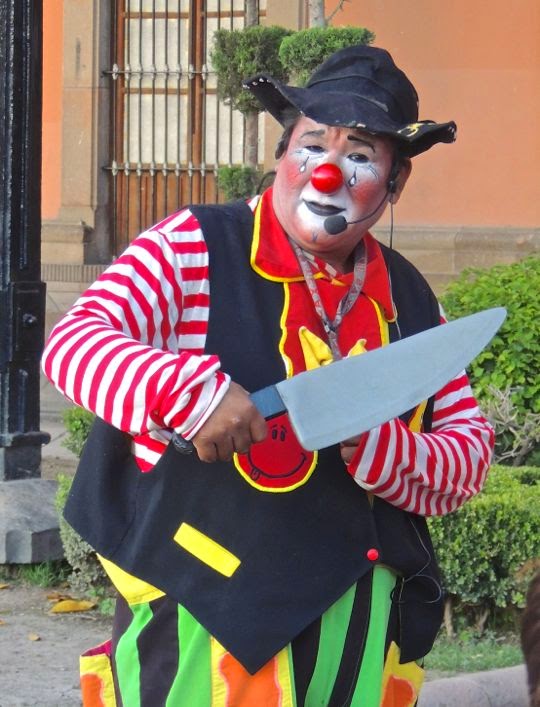
Clowns entertain a group of students in front of the Museo del Virreinato.I have rarely visited a city in Mexico without encountering at least one clown. Usually there are whole troupes of them. These two had the "happy" and "sad" routine down pat. When I took this shot, the clown on the right had just spotted me. The sly grin on this face did not bode well.


The "sad" clown tests his blade as he looks me over like a butcher considers a piglet. As a foreigner with a camera, I often become a target for clown humour, so I try to remain discreetly in the background lest I be drawn into the act. Discretion being the better part of valour, I moved off across the plaza.


The Teatro de la Paz stands next door to the Museo del Virreinato. The Teatro is clearly a product of the late 19th Century Porfirato. The Neo-classical facade, with its stately Corinthian-capped pillars, is typical of the great theatres constructed all over the nation during that period. The Porfirato is named for President Porfirio Diaz, Mexico's dictator from 1876 to 1911. The first stones were laid in 1889, under the direction of architect José Noriega, and the building was completed in 1894. The Teatro can seat 1450 people and is decorated throughout with sculptures. The dome is covered with Belgian bronze.

Again, a group of students cavorts while I take their picture. This was a different group on a different day, but the attitude was almost identical. I began to suspect there might be an instruction booklet for students: "This is how you act when a strange-looking foreigner points his camera at you." Both the kids and I had a lot of fun with it.


Directly across from the Teatro stands the Museo Nacional de la Máscara. The Mask Museum occupies the southwest corner of the plaza. The building was constructed in 1897 as a mansion for a wealthy miner and landowner named Marti. Even without the museum, the building would be worth visiting because it is an architectural jewel. In later years, the Marti mansion was taken over by the federal government to house various agencies. Finally, in 1982, it became the Museo Nacional de la Máscara. The museum houses approximately 25,000 masks, largely from the Victor José Moya collection. Most of the masks were  created by Mexico's various indigenous groups, but some are from other parts of the world. Wandering through the many rooms of this museum takes you through a world that ranges from nightmarish to hilarious.


Monumento al Padre sits on a bench at the side of the Mask Museum. The Monument to the Father has a simple theme, showing a man playing with his young son and daughter. A pair of brothers, Joel and Mario Cuevas, sculpted this affecting work. It was inaugurated in 2008 and a plaque beside it reads:

"Only a parent possesses the necessary art of being able to inspire in their children respect, love, and friendship, all at the same time."


Restaurante Nicolle is another that sits above the plaza. The west side of the plaza is filled with commercial establishments like this second floor restaurant, as well as the internet cafe and artisan shop below it. There is something to be said for an open-air restaurant high above a street. If this were a sidewalk cafe, the heavy traffic, noise, and fumes would create an unpleasant ambiance.


A tall, colourful catrina decorates the roof of still another restaurant. The Plaza del Carmen is a lot of fun to visit, as you have seen. The architecture is gorgeous and varied, the museums are full of fascinating exhibits, and people-watching opportunities are plentiful. Just watch out that you don't get roped into a clown's act.

This completes Part 4 of my San Luis Potosí series. In my next two postings, we'll take a look at the Virreinato and Máscara museums. I hope you have enjoyed this post and, if so, please feel free to comment or ask questions. You can do so either by using the Comments section below or by emailing me directly.

If you leave a question in the Comments section, PLEASE leave your email address so I can respond.

Hasta luego, Jim


San Luis Potosí Part 5: The Marti Mansion and its Mask Museum

$
0
0
Wooden devil mask from the state of Michoacan. Carole and I have always been fascinated by the indigenous masks of Mexico, as well as the dances associated with them. In fact, we have assembled our own small mask collection from Michoacan, Guerrero, Oaxaca and elsewhere. The use of masks for religious and spiritual purposes extends back at least to the Olmecs, thousands of years into pre-hispanic times. When the Spanish arrived, the indigenous people incorporated Catholicism into their ancient beliefs. Masks that seem to be about Catholic themes will often carry pre-hispanic meanings.  In addition, some of the masks were used in dances that covertly ridiculed the white oppressors. San Luis Potosí's Museo Nacional de las Máscarasis located in an opulent former 19th Century mansion. The mansion occupies the southwest corner of the Plaza del Carmen. To find the Mask Museum on a Google map,  click here:


The Marti Mansion

The beautiful Marti Mansion would be worth a visit, even without the Mask Museum. The large, two-story structure was built by a wealthy miner and hacienda owner named Ramon Marti. In 1894, at the height of the opulent era called the Porfirato, Marti purchased and demolished five adjoining homes. Using the engineer Enrique Campos, Marti erected this Neo-classic palace. Campos finished the work in 1897.


The central courtyard is occupied by a complex set of interlocking staircases. The effect is graceful and airy, rather than ponderous and imposing. The rooms surrounding the courtyard on both levels are now occupied by the display salons and museum offices.


The salons show the typical decorative elements of Porfirato architecture. The Porfirato was named for Porfirio Diaz, Mexico's dictator for the 35 years between 1876 and 1911. During this era, Mexico's wealth increased dramatically as foreign investment brought railroads, telegraph networks, new ports, and many new industries. However, the overwhelming majority of this new wealth was concentrated in the hands of a small number of Mexicans surrounding Diaz. Beautiful homes like this were only possible because the mines, industries and haciendas owned by men like Marti paid their workers just enough to survive and sometimes not even that. Labor unrest in the mines and factories was kept in check by the iron hand of Diaz' secret police and military. Farm workers who tried to escape the debt slavery system of the haciendas were caught and returned by Diaz' fearsome rural police force called the Rurales.


Ornate plaster cherubs and floral motifs adorn the ceiling. Ramon Marti didn't get to enjoy his pleasure palace for long. He died in 1898, only a year after construction was finished. His heirs apparently viewed it as a "white elephant" and sold the property in 1903 to a Diaz supporter, General Bernardo Reyes. He, in turn, sold the house to the federal government in 1907. For the next 75 years, the Marti Mansion served as the Palacio Federal, housing a variety of agencies such as the Federal Public Ministry, the League of Agrarian Communities, the Mining Council, and the National Telegraph of Mexico.


This ceiling shows a winged cherub frolicking among colorful flowers. After decades of wear-and-tear, in 1982 architect Fernando Valdez Lozno remodeled the building. That same year, the current museum was created. The 2,500 piece collection of Victor José Moya Rubio and his wife Mildred Dingleberry Himm became the core display. Then, in 1998, the building had to be rehabilitated because of cracks that threatened to split the structure in two. The Instituto Nacional de Antropologia y Historia (INAH) has designated the Marti Mansion as a historic monument.


Masks and mask-making in Mexico

Masks have been and still are used in dances and rituals in virtually every corner of Mexico. A few examples typical of their region can be found on the map of Mexico seen above. At the time of the Conquest there were between 100 and 200 distinct tribal groups within the borders of what is now Mexico. Even today, there are still at least 60 distinct indigenous languages spoken here. The themes of the masks and the materials from which they are made vary from region to region according to local resources and traditions.


Skull mask of Tezcatlipoca, one of the most powerful gods of the Aztec pantheon. The surface of the mask is inlaid with bone and turquoise. The turquoise was brought down from what is now New Mexico to the Aztec Empire. For more information on Tezcatlipoca, see my posting on the Aztec Cosmos. However, the Aztecs were relative latecomers to the world of mask-making. 2,500 years before them, the Olmecs were carving extraordinarily fine stone masks of various sizes. Some of these have been recovered from sites along the Gulf Coast of Veracruz and Tabasco. Others have been found in Colima on Mexico's West Coast and in Costa Rica to the south.


Masks are made from a variety of materials, including finely woven natural fibres. The kinds of materials used include sisal agave, dehydrated cactus leaves, dried corn husks, gourds, and coconut fruit rind. The use of these fibres goes back to the very dawn of Mesoamerican civilization. Some modern mask makers still use such materials.


This Huichol mask uses both human hair and wood. The painted designs include a deer, which is one of the most sacred symbols of this culture. The Huichol have tenaciously maintained their traditions, rituals, and mode of dress. As a mask material, wood is highly preferred by many indigenous craftspeople, including the Huichol. It is easy to acquire, durable, malleable, and possesses healing and magical qualities. To obtain the wood, trees are cut ceremonially, at precise times and under particular conditions relating to climate and astronomy. Among the favored woods are pine, copal, mesquite, cedar, and avocado.


Another natural fibre mask of a more primitive design. This mask was unidentified, but may have come from northern deserts of Mexico once inhabited by nomadic hunter-gatherers called Chichimecs. These nomads tended to favour such light materials because, lacking fixed abodes or draft animals, they had to carry all their possessions from place to place.


Settled groups could afford to use more delicate materials like clay. Masks such as these are favored in places like Oaxaca, where the local black clay is used to produce especially fine work. The Zapotecs of Oaxaca were contemporaries of both the Olmecs and the Aztecs, giving them one of the longest continuous histories in Mexico. Other places specializing in clay masks include Metepec in Mexico State, and Tonalá and Tlaquepaque in Jalisco State. As with the wooden Huichol masks, the ones above are adorned with human hair. Notice the eye slits just above the painted eyeballs.


Güe Gües and Devil Dancers

A Güe Güe sporting a huge blonde "Afro"holds a characteristic whip.Güe Gües appear at many indigenous fiestas and dances. They wear terrifying masks and crack their whips as they move around the fringes of the mass of dancers. I have seen them in action at dance fiestas as widely separated as Tuxpan in southern Jalisco and the northern Puebla State mountain town of Zacatlán.


Another Güe Güe wears a horned mask and clutches a small doll. Dolls are often carried by these characters and may symbolize fertility. Güe Gües are associated with both devils and the aged. They represent the on-going struggle between good and evil, a post-Conquest concept which has been incorporated by indigenous peoples into their fiesta rituals.


This Güe Güe looks like a "flasher" from a horror movie. His mask is both terrifying and hilarious. The whip he carries in his right hand will be used to exact "penance" from dance participants. Some authorities think the whips carried by Güe Gües are related to the experience of African slaves imported into Vera Cruz and Guerrero States. Over time, the slaves inter-married with indigenous people and the result was a amalgam of African and the New World cultural traditions.


Diablo de la Pastorela mixes indigenous with biblical imagery.  Pastorelas are plays that recreate biblical passages related to the Nativity. In that story shepherds were alerted to the birth of Jesus by an angel who directs them to look for him. These plays were introduced by evangelizing friars as a way of teaching Christianity to the newly conquered-and-converted indigenous populations. In the Pastorela plays, devil figures wearing masks like this try to distract and mislead the shepherds from their quest. This mask comes from the Purépecha crafts workers of Michoacan. They are an indigenous people who are famously skilled at woodworking.


Three wood and polychrome masks from Chilacapa, Guerrero. These masks were used in the Danza de los Siete Vicios (Dance of the Seven Vices). Although the masks above seem rather nightmarish, the diablos or devils of Mexican dances are typically irreverent or satirical characters. Their goal is to subvert morality and they will often provoke laughter in the spectators through their vulgar comments. Notice that the tongue of the mask on the left is the head of a serpent.


The sly smirk on this fellow's face indicates he is up to no good. This wooden mask from Guerrero includes a human-hair beard. Underdlying the good vs evil dichotomy imposed by the Church are indigenous meanings that are much more complex. The figures represent beings of the spirit world that carry a wide range human attributes, as well as attributes of the ancient gods.


Masks and the Animal World

Both in life and in the indigenous spiritual world, the jaguar is extremely powerful. It is the largest and most powerful non-human land predator in the Western Hemisphere. In the world, only the Indian tiger and the African lion are larger. This animal has been the symbol of warriors, nobility, and the underworld from the earliest times. The Olmecs left many stone monuments showing half-human, half-jaguar figures. Some of these were carved so that they appear to be emerging from underworld caves. The physical manifestation of the Aztec god Tezcatlipoca was a jaguar. The great Toltec and Aztec military empires and the Maya city-state of Chichen Itza all fielded armies led by jaguar warrior-societies. Since it hunts at night, the big cat was believed to possess the power to cross over to the dark world of the spirits. The brightly-painted wooden mask above uses stiff animal hair to represent the jaguar's whiskers and eyebrows.


Masks used in la Danza de los Murciélegos (the Dance of the Bats). These animals have been considered sacred for thousands of years because of their association with darkness and caves--seen as entrances to the underworld. The Aztecs revered a Bat god called Camazotz.  However, worship of bats may have originated with the Zapotecs, almost 1,400 years before the Aztecs made an appearance. A beautifully caved bat mask made of jade with shell eyes and teeth has been unearthed at the ancient Zapotec capital of Monte Alban and archeologists date it to 150 BC. The masks above are from Guerrero State and were carved from wood.


Crocodiles are another important symbolic animal. Sometimes masks, like the wooden one above, depict only the head of the croc. Others are constructed to show the whole animal and are worn around the waist of the dancer. The head and mouth extend in front of the dancer and the tail stretches out behind his back. Crocodiles were called Cipactli by the Aztecs and were associated with the cardinal direction of east. The 260-day Aztec religious calendar was divided into twenty segments of 13 days, with each segment related to a particular god. The crocodile was the symbol of one of these segments and the associated god was Ometeotl, god of duality and creator of all the other gods. The god Tezcatlipoca was one of Ometeotl's sons. According to the mythology, he lost his foot to a great crocodile monster. Perhaps the message was: don't mess with Dad's pet.


This extraordinary mask and head dress may come from the Colima area. There was no informational sign about its origin, but I encountered a very similar mask when we visited a crafts workshop in the City of Colima. The head dress worn by this kneeling figure is huge and must be quite heavy. However, its size and weight are not the most unusual aspects of this work.


The open mouth of the bull mask contains another mask with a stylised human face. I have seen a lot of masks in Mexico, but have encountered few that contain a mask-within-a-mask. In addition to that oddity, the wearer can manipulate the head dress with the tasseled cord in this left hand, as well as the one hanging down on the right. What exactly happens when he pulls the cords is still a mystery to me, but the effect is no doubt spectacular.

This completes Part 5 of my series on San Luis Potosí. Next time, we will continue with the Mask Museum to see masks that reflect the Spanish Conquest and the imposition of Catholicism on the native population. If you enjoyed this posting, don't hesitate to leave a comment or a question. You can do so either by leaving your message in the Comments section or by emailing me directly.

If you leave a question in the Comments section, PLEASE leave your email address so I can respond.

Hasta luego, Jim


San Luis Potosi Part 6: Masks of the Post-Conquest Era

$
0
0
Figure dressed for the Dance of the Moors and the Christians. Although the North African Moors were a brown-skinned people, indigenous mask makers in Mexico usually portray them with white faces. Behind the Moorish mannequin is a large photo of a mask-maker at work. Las Danzas de los Moros y Cristianos commemorate the 700-year struggle of Christians to expel the Muslim Moors from Spain. In my previous posting on the National Mask Museum, we looked at indigenous masks with pre-hispanic themes. This week I'll show how the masks changed after the 16th Century Spanish Conquest. In the last section of the posting, you'll see some of the gorgeous masquerade costumes of Venice, Italy. These were part of a short-term, traveling display.


Portrayals of the Spanish Conquerors

Masks with white faces from Guerrero State. The people who wore these wood masks portrayed various characters in the Dance of the Moors and the Christians. All the faces are male with white or pink skin and long noses. Most of the faces show beards and/or mustaches. Many have rouged cheeks that give them an almost clown-like appearance. This was probably due to the sunburns that the light-skinned Spanish would have acquired from Guerrero's intense sun.


Mask expressing the duality of the cosmos.Duality was a fundamental concept in the pre-hispanic world. Everything has its opposite, and together they form a whole. Each part is inextricably connected with its other side: male-female, day-night, life-death, etc. Each can only be understood, or even exist, in relation to its opposite. Above, this Janus-like mask expresses duality using two blonde figures, male and female. The native people often portrayed the Spanish satirically, so this double mask might express the two-faced nature of white overlords. One the one hand, the Conquistadors brought Christianity, on the other, enslavement and cultural genocide.


A sun-burnt Spanish Conquistador, wearing a golden helmet. This carved, wooden mask from Guerrero gives us an idea of how the conquerors appeared to the native people. When the Spanish arrived in Guerrero, most of the indigenous people fled the fertile Pacific Coast plains to the safety of the mountainous interior. Consequently, the Spaniards had to work their own fields, at least at first. Eventually, they imported African slaves to do the work. The mix of Spanish, African, and indigenous cultures gives this part of Mexico an interesting cultural twist.


This dancer portrays a doddering old man, leaning on a cane and wearing a white mask.La Danza de los Viejos (Dance of the Old Men) originated in Michoacan State and is famous throughout Mexico. The dancers are actually very athletic young men who start their performances with slow creaky movements.  Gradually, they increase the tempo to a very energetic and acrobatic level. The dance was created by the Purépecha people to covertly mock their Spanish rulers. The indigenous people did all the actual physical work in colonial Nueva España. The Spaniards sat comfortably on their horses and watched, never getting any real exercise. Consequently, they aged rapidly and became old and hunched, as portrayed by the dancers. We have seen this entertaining dance performed in the plazas of the Michoacan cities of Patzcuaro and Morelia.


Wooden mask from la Danza de los Locos (Dance of the Crazies). According to Yolanda Lastra, in her book Adoring the Saints: Fiestas in Central Mexico, "A type of crazies, men dressed as women, existed in pre-Columbian times and were adapted immediately after the Conquest as characters to mock the Spaniards...today, groups of crazies who take part in patron saint fiestas continue this tradition... the crazies and the giant puppets are two of the bawdiest, most grotesque, and satirical components of the patron saint fiesta."


La Danza de los Moros y Cristianos

An elaborate, brightly ribboned mask of a goateed Moor. In 711 AD, a Moorish army crossed from North Africa to Gibraltar and began the invasion of Spain. The army consisted of North African Berbers but was officered by Arabs accountable to the vast Umayyad Caliphate that would eventually stretch from southern France to modern Iraq. The conquest of Spain took only seven years, but holding it was another matter. For a time, the Moors controlled nearly all of Spain and even extended their reach across the Pyrenees Mountains into southern France. Eventually they were forced back into Spain. Internal dynastic squabbles weakened them, as did a series of religious coups by groups that were increasingly more radical in their interpretation of Islam. Christian rulers in the remaining non-Muslim pockets of Spain used these Moorish divisions to begin La Reconquista (the Re-Conquest).


The mask of the Moorish King Pilates is topped with an elaborate head dress. The wooden mask is from Apaxtla, Guerrero. The Dance of the Moors and the Christians commemorates the Battle of Clavijo which occurred in either 841 or 844 AD, depending on your source. According to the legend, this early Christian victory was the start of la Reconquista. As the story goes, Santiago Matamoros (St. James the Moor Slayer) appeared at a critical moment in the battle and led the Christian forces to victory over Pilates and his Moors. This was how the Apostle James gained the nickname Matamoros. Most historians don't believe the battle actually happened. Apparently it was invented hundreds of years later by people who wanted to rally Spanish support for la Reconquista by making Santiago Matamoros the patron saint of Spain.


Mask of a bearded Christian warrior with a fanatical stare. This fierce-looking wooden mask was made in Ostotitlán, Guerrero for the Danza de los Santiagos. The danceis one of the innumerable versions of the Danzas de los Moros y Cristianos. From the time of the Moorish invasion through the mid-10th Century, there were continual wars and skirmishes between the Moors and Christians. However, these appear to have been more territorial than religious. At times Moorish princes would enlist Christians as allies or mercenaries to fight their Moorish rivals. Sometimes the Christian feudal lords, while squabbling among themselves, would use Moorish troops for the same purpose. It was all very messy but, over time, the Christian-controlled regions gradually expanded. The Muslims were steadily forced back toward the south and east coasts of Spain.


Mask of the Christian King, made in Apaxtla, Guerrero. Toward the end of the 11th Century, la Reconquista mutated from simple territorial skirmishes into a full-scale religious war. This process accelerated when, in 1095 AD, Pope Urban II called for a Crusade to free the Holy Land. This First Crusade was one of several waged over the following centuries. The Crusades drew Christian warriors from all over Europe into conflicts with various parts of the Muslim world, including Spain. Some of the early Crusades were successful for a time because the Muslims were relatively unprepared. However, the Muslims ultimately recovered nearly all the territory the Crusaders captured. The only unqualified Crusader success was la Reconquista. In 1492, the south-coast principality of Granada was the last remaining Moorish stronghold in Spain. When it fell to the husband-and-wife team of King Ferdinand of Aragon and Queen Isabella of Castille, the 700-year Reconquista was complete. During the last stages of their siege of Granada, a young Italian named Christopher Columbus waited impatiently in Ferdinand and Isabella's camp. He was eager to present a proposal to sail westward over the Atlantic in hopes of landing in Asia. As it turned out, he discovered a New World, transforming Spain from a poor, barely-unified medieval state into the seat of one of the largest and richest empires the world had ever seen.


Santiago Matamoros, in typical dress and mounted on a white charger. When the figure portraying Santiago is not mounted on a real horse, the dancer will wear a small, wooden horse's head protruding from the front of his costume. Ferdinand and Isabella and their successors used lessons learned fighting the Moors to conquer their new overseas empire. La Reconquista had produced a Spanish army that was filled with highly trained, battle-hardened, and ambitious soldiers. Arguably they were the best in the world at that time, but they were a dangerous group to keep standing around idle. The New World was a good place to send them and they proved spectacularly successful. In addition, the Spanish had developed the encomienda system to handle newly-conquered Moorish lands. Transferred to the New World, this system allowed a Spaniard who subdued a local population to be granted an encomienda, or the right to demand free labor. On his part, the new overlord had the responsibility to ensure that the locals were properly Christianized. New World encomiendas were very beneficial to the Spanish conquistadors but disastrous to the native populations. Lastly, the bloody-handed but victorious Santiago Matamoros became the patron saint of those fighting to conquer the New World's non-Christians. Newly-arrived Spanish priests pushed the indigenous people to celebrate the Spanish defeat of the Moors. The resulting fiestas became imbued with all sorts of pre-hispanic meanings not intended and probably not understood by the priests. To see an example of this, check out the Danza de los Tastoanes, held annually in Tonalá, near Guadalajara.


Danzas de la Santa Semana (Holy Week Dances)


One of the Semana Santa dances in Nayarit State features this "borrado" or Jew. Semana Santa is the week-long Christian tradition also known as Easter Week. Catholic priests taught the Cora people of the Sierra del Nayar that the Jews were the persecutors of Christ. The figure above represents the Cora vision of what a borrado, or Jew, would look like. Shortly after la Reconquista, Queen Isabella banished the Jews from Spain. After a couple of generations, the Spanish priests themselves probably had no idea of what a real Jew looked like. In addition to the strange beak and horns, the dancers paint their bodies from the neck down with horizontal black and white stripes.  At the end of the dance, the borrados proceed to a local river where they symbolically immerse themselves. Their stripes are washed away, their masks float off with the current, and the dancers emerge again as good Christians. Interestingly, according to a pre-hispanic Cora tradition, their sun god Tayau was buried and reborn. This similarity to the Christian resurrection story was probably used by Catholic priests to help evangelize them.


This Semana Santa dancer is dressed as a Jewish fariseo (Pharisee). The goat skin masks of these Mayo dancers of Sonora State typically have grotesque features. Part of the function of the the fariseos is to walk around the pueblo asking for limosna (alms) to help cover the cost of the fiesta. During the dances, the fariseos circulate, playing tricks and practical jokes. At the end of the dance, they doff their masks and costumes and throw them in a great bonfire to demonstrate the triumph of good over evil. Queen Isabella was a religious fanatic who favored forced conversions of Jews (and Muslims) and expelled any who refused. In her view, the Jews, led by the Pharisees, were Christ-killers. This prejudice survived well into the 20th Century among many Christians. The masks and dances of some of Mexico's indigenous groups reflect the beliefs they have been taught by the Church from the earliest days of the Conquest.


Mask from Guerrero showing a grinning Roman Centurion with huge fangs. The Romans are the other evil-doers in Semana Santa pageants. The Romans, after all, are the ones who carried out the actual crucifixion. This huge wooden mask must have sat very heavily on the shoulders of the dancer wearing it.


Masks of the Venetian Masquerade

An elegant figure with a gold mask displays a lacy fan. The gold mask is called a volto (Italian for "face"). It was not clear to me whether this is a male or female figure. Given the fan, I'd probably vote female. While most of the National Mask Museum is devoted to its permanent displays, there are also temporary displays from other parts of the world. When we visited, the Museo was showing the masks and costumes of the Venice Masquerade. The mannequins of the display fit in perfectly with the elegant salons and drawing rooms of the 19th Century mansion formerly belonging to the Marti family.


The cap with the bells indicates that this figure is some sort of court jester. The mask appears to be of the style called bauta. The Masquerade is a part of the activities occurring during the Carnival of Venice. This great festival begins in January and ends on the first Tuesday in March (Fat Tuesday or Mardi Gras). According to legend, the Venice Carnival began as a celebration of the victory of the Republic of Venice over the Patriarch of Aquileia in 1162 AD. During the Renaissance, the Carnival became an officially sponsored event. At the end of the 18th Century, when Venice was ruled by the King Austria, the event was outlawed and the use of masks forbidden. The Carnival was revived in the 19th Century, but mostly for private parties. In 1979, the Italian Government once again sponsored the Carnival as a way of bringing back the history and culture of Venice.


An elegant couple wear two distinctly different types of masks. The woman (left) wears a Columbina covering the upper half of her face. Her lower face is covered by a sort of fringed veil hanging from the bottom of the mask. The male figure (right) wears a volto, along with a tricorn hat and a cape. In Medieval and Renaissance Venice, there were many occasions throughout the year when people wore masks, in addition to the Carnival. In fact, the wearing of masks and cloaks by men in public meetings was required as a way of keeping their identity secret when they voted. This seems to have been an early expression of the secret ballot. While dressed for this public purpose, men were forbidden to carry weapons.  In 1339 AD Venetians were also forbidden to wear masks and vulgar disguises while visiting convents. This may have been to inhibit carnal activity with the nuns.


This figure wears a gold volto, topped with a bishop's mitre (hat). The figure seems to be a female but, since the purpose of masks and disguises is concealment, who knows? The makers of the Venetian masks were called mascherari. Their craft was officially recognised by law in 1436 AD. They were sometimes assisted by sign-painters who helped decorate the masks with detailed designs.


A Medico della peste rests in a chair while clutching his stick. A Medico della peste (Plague Doctor) was a physician who dressed like this to treat plague victims, not to celebrate. The outfit was developed by the French doctor Charles de Lorme in the 17th Century. The mask and spectacles were used to protect against catching the disease. Medicos della peste moved their patients using the stick to avoid touching them. This was the 17th Century's version of a modern Ebola "HazMat" suit. Use of this costume in the Carnival is entirely modern, but very popular.

This concludes Part 6 of my San Luis Potosí series. It is also the last of the National Mask Museum. I hope you enjoyed this amazing museum and that you take the time to visit it if you get to San Luis. I always appreciate comments and questions. If you'd like to make one, please leave it in the Comments section below or email me directly.

If you leave a question in the Comments section, PLEASE leave your email so I can respond.

Hasta luego, Jim

San Luis Potosí Part 7: The colonial-era displays of Museo del Virreinato

$
0
0
Beautifully crafted keys and locks on display at San Luis'Museo del Virreinato. This fine museum is devoted  to the 300-year colonial period when Spain ruled Nueva España (today's Mexico). Carole and I visited Museo Virreinato (Museum of the Viceroyalty) during our stay in San Luis Potosí in August of 2013. The museum illustrates the life of the Spanish overlords who dominated an overwhelmingly indigenous, mestizo (mixed race), and African slave population. The locks and keys seen above are a fitting metaphor for the tight control that Spain maintained for nearly three centuries over its New World colonies. Ironically, the stultifying political, social, and economic effects of that control led to the violent revolts, including the 1810 Mexican War of Independence. By the late 1820s, Spain had lost control of nearly all of Latin America. The Museo Virreinato is located on the east side of the Plaza del Carmen, between the Templo del Carmen and the Teatro de la Paz. 


Museo Virreinato

The Museo is housed in an 18th Century Carmelite convent. The central courtyard is reached by walking through an entrance hall called a zaguan. The term zaguan dirives from an Arabic word, and much of Spanish colonial architecture was heavily influenced by Arabic/Moorish styles from Spain. The Carmelite Order built the convent between 1768 and 1771. During the mid-19th Century reforms of Benito Juarez, the building was confiscated and partly destroyed. Over time, it was used as a barracks, warehouse, jail, and for offices. In 1936, the building was declared a national monument and now serves as a museum.


The pillars around the courtyard are of the simple Doric style. The central courtyard is surrounded on all four sides by an open arcade bordered by pillars separated by arches. These are called portales. The rooms of the building are generally accessed from the arcade, although there are internal passageways between some of them. The slightly overgrown garden is laid out in an 18th Century style. Architectural styles in Nueva España were heavily influenced by those that were popular in Spain at various times, including Gothic, Roman, Baroque, and Neo-Classical, among others.


Religious artefacts of the Colonial Era

Painting of San Francisco de Assisi. The portrait was painted by an anonymous artist toward the end of the 19th Century. In May of 1524, Martin de Valencia led twelve Franciscans off a ship at Vera Cruz. Because they arrived just after the fall of the Aztec Empire, the Franciscan Order were able to "get in on the ground floor." The Dominicans, Augustinians, and other religious orders did not show up until some years later. In fact, the Franciscans had already started the New World's first evangelization project in 1500 when they built their mission on the island of Santo Domingo (today's Dominican Republic). Thus, before they ever set foot in Nueva España, the Franciscans already had almost a quarter century's experience evangelizing indigenous people of the New World. Consequently, a very large proportion of the churches, convents, and other religious facilities built in the 16th Century were associated with the Franciscan Order.


Typical habit of a Franciscan friar. In 1570, the Franciscans established themselves in San Luis Potosí and, once again, they were the pathfinders for all other religious orders. The Augustinians arrived in 1599, the Juaninos (Hospitaller Order of St. John of God) in 1607, the Jesuits in 1621, the Mercedarios in 1628, and the Carmelites in 1743. The Dominicans didn't show up until the beginning of the 20th Century. As wave after wave of friars arrived, 16th Century historian Gonzalo Fernandez Olviedo wrote "It seems to me that these lands are flooded with friars; but none are greying, all being less than thirty years old. I pray to God that they are capable of serving Him."


Habit worn by the Mercedarios. The Orden de Mercedarios(The Royal Military Order of Our Lady of Mercy and the Redemption of Captives) was founded in 1218, at the height of the Crusades. At that time many Christians were held captive by the Muslims. From the earliest days of Spanish involvement in the New World, even before the discovery and conquest of Nueva España, the various Orders had profound differences of opinion about the nature of indigenous people. Even within particular Orders there were disputes. Some thought the native people were soulless beasts, not even human, and fit only for slavery. Others thought they possessed human souls but had the minds of children, with only a limited ability to reason. A few, such as the Bartolome de las Casas in Chiapas and Vasco de Quiroga in Michoacan, thought the New World's original inhabitants were fully human and, as such, had rights that should be protected from greedy and rapacious conquistadors. Unfortunately, the view of native soullessness fit all too nicely with the interests of gold-hungry Spaniards, eager for slaves to work their mines and other projects. This was also how many of the great churches, cathedrals, and convents of the 16th and 17th Centuries were built.


A finely embroidered 18th Century chasuble, along with a chalice used in the Eurcharist. A chasuble is an outer vestment, worn only during the ceremony of the Eurcharist (also known as Communion). The chalice, seen on the pedestal to the right, will be used to hold wine for the ceremony. Chasubles originated as ancient Roman outer garments. Over the millennia, they were gradually transformed into a garment worn in one of the most important Catholic rituals. While this garment may have been imported from Spain, it might also have been crafted locally. Indigenous women were--and still are--highly skilled at embroidery.


A wood sculpture carved using the estofado technique. This sculpture of a Doctor of the Church was carved at the end of the 17th or the beginning of the 18th Century.  Wood was the most common material for colonial sculpture, and estofado was the most common method of carving it. The process was complicated, but a key part involved the application of paint made from gold leaf which helped preserve the wood. This piece may once have been part of a tall wooden retablo standing behind an altar.


San Joaquin and Santa Anna, dressed as if they were royalty. These figures were crafted sometime in the last third of the 19th Century. According to Catholic tradition, Joaquin and Anna were the parents of the Virgin Mary. However, there is no mention of either of them in the Bible, and their feast day was not included in the official Roman Catholic calendar until 1584. The date for the feast migrated around over the centuries until 1969, when it was finally set for July 26. The creator of the statues apparently considered royal clothing appropriate for of the parents of the Virgin Mary. Although the Virreinato ended in 1821, a number of displays from later periods are included in the exhibits.


Clothing styles across the centuries


Fashionable dress of 18th Century Nueva España.  The society of the Virreinato was organized as a rigid caste system. Those at the top were all born in Spain, and known as peninsulares. They filled all the key political and military posts of Nueva España. Those who had Spanish parents, but were born in the New World, were called criollos. Many criollos became immensely rich through mining, commercial interests, and great haciendas. However, for 300 years a glass ceiling separated them from the posts at the top. Under this system, the callowest youth from the mother country outranked a mature criollo, regardless of his great estates and years of experience. Over time, the criollos chafed at the unfairness and sheer lack of sense behind this system. Many of the criollos who supported the insurgency during the War of Independence (1810-1821) were not particularly interested in creating a socially just society. Their first priority was removing the barriers that separated them from the lucrative top posts. From the point of view of the non-Spanish mestizos, indigenous people, or black slaves, the triumph of the criollos over the peninsulares was simply a case of "here comes the new boss, same as the old boss."


An early 19th Century mother and her daughter. The first European women to arrive in the New World came on the third voyage of Colombus. Throughout the 16th Century, there were Spanish women in Nueva España, but only a few at first. During this early period, Spanish men created the mestizo class through cohabitation, casual contact, or even outright rape of indigenous women. However, by the beginning of the 17th Century, European women had become well-established in colonial society. Like men, they were either peninsulares or criollos. During the Virreinato, women were considered the property of their fathers, initially, and later their husbands. Depending on her marital status, either the father or the husband had the right to kill her if she brought shame upon the family. Interestingly, in terms of controlling property, single women had far more rights than those who married.


This 19th Century wedding dress looks quite modern. Despite all the restrictions, women sometimes became powerful "silent partners" in their father's or husband's business affairs. Women who never married, or became widows, sometimes ran the family business or hacienda on their own. Occasionally, women who showed great intellectual promise were allowed to develop those gifts. Such a person was Sor Juana Ines de la Cruz, an intellectual, poet, and 17th Century feminist. At an early age, she was taken under the wing of the Viceroy's family. While living in the palace, she studied philosophy, science and poetry. Sor Juana eventually became a nun, but her feminist writings about the double standard between men and women deeply angered Church authorities. She was forced to do penance, which included giving up her 4000 book library. Sor Juana died a tragic figure during an epidemic in 1695, but her fame did not die with her. Her life, writings, and poetry are still studied today and the 200 peso bill of Mexican currency contains a serene portrait of this early feminist.


Spanish homes in Nueva España

Finely carved furniture such as this would have graced the Virreinato's salons. When the Spanish arrived, only the Aztec elite possessed any significant amount of furniture. This was made in the equipalestyle, with leather and wood strips. Equipale is still highly popular in Mexico today, and my home in Ajijic is furnished with it. The colonial homes of the 16th Century were fairly austere, containing mainly rough-cut benches, tables and stools. In the 17th and 18th centuries, the growing wealth of the Spanish inhabitants allowed them to import furniture from Spain, and to employ indigenous artisans to make furniture locally in the European style. People tend to emulate the styles of those they see as their social betters. The peninsulares, with their supreme positions, set the style, and that was of the Mother Country. The criollos copied them and the mestizos followed suit, if they could afford it.


Blue and white china from the Far East. This plate is from the last third of the 18th Century. Dishware like this arrived on the treasure galleons that sailed a regular round-trip route between Manila, in the Philippines, and Acapulco, on the southwest coast of Nueva España. The dishware originated in China and was among the many luxury items collected from all over the Far East. Manila was the collection point, and thus was a key base for the world-wide Spanish trade network. After arriving in Acapulco, many of these luxury items were carried by pack-mules cross-country to Vera Cruz, and then to Spain. However, some of the items were sold to local merchants who then offered them for resale to furnish the Spanish homes of Nueva España. The Manila/Acapulco treasure galleons were preyed upon by the many pirates who rampaged over the oceans during the 16th, 17th, and 18th Centuries. England's Sir Francis Drake was one of the most famous of these. The Spanish, of course, thought him thoroughly infamous. In modern terms, Drake's exploits would look quite a bit like terrorism, so perhaps the Spanish were right.


Silver ware such as this was used to set the tables of colonial mansions. Although mining centers such as Zacatecas and Guanajuato produced immense amounts of silver, it was generally sent to Spain in the form of ingots. Spanish artisans in the Mother Country would manufacture silver items for sale in Spain, Europe, or for shipment back to the markets of Nueva España. Most forms of colonial manufacturing were severely restricted. From the home country's point of view, the purpose of the colonies was two-fold: first, to supply raw materials, and second, to provide markets for goods the home country manufactured from those materials. In the end, the restrictions fomented resentment, inhibited the development of Nueva España's economy, and produced considerable smuggling to feed a lively black market.


Various objects familiar to colonial homes. On the lower left is a high-relief, crystal bowl. Above it sits an object called a "porta veladora." I am not sure of its function, but the name implies that it was used to carry candles. On the upper right are a glass fruit bowl and a silver candlestick. At the bottom center is an ink blotter used to soak up excess ink from writing with a quill pen.


A sturdy, iron-bound chest ensured that possessions remained secure while traveling. Notice the painted scene on the inside of the lid. Carriages with matched horses like those portrayed would have been common sights on the streets of San Luis Potosí. The chest is made from wood and covered with leather. It was strengthened with iron rivets and fittings and has a large circular lock on the front. The chest was crafted in the last third of the 18th Century.


A brass bed is bracketed with carved wood nightstands topped with white marble. Colonial beds often seem a bit short to me, but then people were shorter then too. I have visited many ruins of old haciendas and, among the rubble, found beds and nightstands very similar to these.


Metalwork in Nueva España


Oil lamps and a padlock with keys. The lamps appear to be made from pewter or tin, while the lock is clearly made of finely wrought iron. Metal work was still at a very early stage among the indigenous groups when the Spanish arrived. The Aztecs possessed a limited number of metal objects, mostly gold jewelry and some copper items like bells. The most advanced metal-working was found in the Tarascan Empire, just west of the Aztec Empire. The Tarascans maintained their independence from the Aztecs in good part through their possession of copper weapons and tools. They were on the verge of a Bronze Age but, before they had a chance to make this leap, their society was destroyed by Spanish steel.


Finely crafted bridles and spurs were the mark of Spanish elite. The Spaniard was the Man on Horseback who dominated all about him. Because of military necessity, the Spanish brought blacksmiths along from the earliest days of the Conquest. They were needed to make and repair weapons, armor, equipment for horses, and every sort of tool. Over time, their skills were passed along to their mestizo descendants and to indigenous craftsmen. The ironworkers of Nueva España adopted the customs of Old Spain, including the Medieval associations of craftsmen called gremios. The gremio associations developed to ensure the quality of the various crafts produced and to protect the interests of the craftsmen. Gremios still exist as worker associations in Mexico today, but their function is more to organize worker support for various religious fiestas.


An old balance scale. Balance scales were invented to measure weights for purposes of trade. The earliest balance scales discovered date back to 2000 BC and were found in the Indus River Valley. The balance principle for weighing objects was not supplanted until 1770, when British inventor Richard Salter invented the spring scale. In the late 20th Century, digital scales began to replace the spring scale. However, scales based on the old balance principle can still be found in modern gyms and doctors' offices.

This completes Part 7 of my San Luis Potosí series. I hope you enjoyed this posting and that you take the time to visit the Museo Virreinato if you come to San Luis Potosí. If you would like to comment or leave a question, please do so in the Comments section below, or email me directly.

If you leave a question in the Comments section, PLEASE leave your email address so I can respond.

Hasta luego, Jim


San Luis Potosí Part 8: The ornate Templo del Carmen

$
0
0
Inside the great dome of the Templo del Carmen. Any visit to San Luis's Plaza del Carmen should include a look at this ornate church. Of the great complex built by the Orden de Carmelitas Descalzos (the Order of the Barefoot Carmelites), the Templo is the only remaining structure still used for religious purposes. This view of the dome's interior provides a sense of the intricate ornamentation that distinguishes the Baroque style, particularly the version called Churrigueresque. To locate Templo del Carmen on an interactive map, click here.


The Templo's Exterior

The facade and tower of the Templo, with the main dome on the left. The Plaza del Carmen, in front of the church, was once occupied by various structures that were part of a large religious complex. The area that formerly served as the convent's orchard is now a huge park called Alameda Juan SarabiaMuseo del Virreinato (Museum of the Viceroyalty), the building to the right of the church, used to be the Carmelite Convent where the friars lived, prayed, and worked.


The two-tiered steeple is supported by spiraling Solomonic columns. Solomonic columns are a typical Baroque feature. The Carmelite Order originated in the early 13th Century among hermits living a life of poverty and contemplation on the slopes of Mt. Carmel in the Holy Land. Their name comes from their adoption of the Virgen del Carmen (Virgin of Mt. Carmel) as their patron. As a result of Christian military reverses during the Crusades, the Carmelitas were forced to leave for Europe. There, they traded their hermetic life for that of friars and nuns. However, faced with the Hundred Years War, the Black Plague, and the Renaissance, the Order became worldly and somewhat demoralized. In 1562, an extraordinary woman named Santa Teresa attempted to revive the Mt. Carmel tradition of isolation, contemplation, and prayer. She founded the Convento de San José for nuns in Ávila, Spain. Since poverty was a key element of the tradition, the nuns were called Carmelitas Descalzos (Barefoot Carmelites). Santa Teresa worked closely with a man called San Juan de la Cruz (St. John of the Cross), who founded a convent for friars with a similar orientation. In 1580, Pope Gregory XIII recognized the Carmelitas Descalzos as an independent unit of the overall Carmelite Order.


The exuberance of Churrigueresque Baroque can be seen in the facade of the Templo. The facade is designed with three sections, one above the other. The section on the bottom and middle are rectangular, while the one at the top is triangular. Each section is filled with intricately decorated columns, floral ornamentation, and niches containing saints. The first Carmelite convent in New Spain was founded in Mexico City in 1586, followed by several more in other parts of the country over the next few decades. When, exactly, the first Carmelites arrived in San Luis Potosi appears to be a matter of some dispute. Various sources cite the  dates of 1735, 1738, and 1743. There is some agreement that Friar Nicolas de Jesus Maria and Friar Joseph of the Assumption were the first to arrive. They managed to obtain a license for a Hospice in San Luis three years later. In 1747, King Philip V of Spain gave the Carmelites permission to found a convent. The first stone for the present church was laid on February 23, 1749.


The triangular top level is filled with religious figures and symbols. Along the roof line are six ornaments called finials. At the peak is a statue of the Arcangel San Miguel. Just below the roof line, cherubs lift a veil to reveal the face of God. Below that, in the center, is a niche containing the statue of the Virgin with the Christ Child. Four pilasters carved in the estipite style are on either side of her. A pilaster is a kind of false column. It functions as an architectural decoration and doesn't support any weight. Between the pilasters are Santa Magdelena de Pazzi on the left and San Angelo on the right. The construction of the Templo and its convent were greatly assisted by funds from the estate of Nicolas I. Fernando Torres, a Spaniard from Seville who married a rich woman named Dona Gertrudis Maldonado Zapata. Using her fortune as a base, he became even wealthier and eventually acquired the Haciendas del Pozo and Peotillos. The marriage produced no heirs and, upon his death in 1752, Fernando Torres left a will dedicating his fortune to the Carmelita Convent and Templo, and also to found Colegio de San Nicolas, a school for girls.


The middle section of the facade centers on the stained glass choir window. Once again four pilasters surround the window, two on each side. Between each set of pilasters is a niche containing the two founders of the Carmelitas Descalzos, Santa Teresa on the left, and San Juan de la Cruz on the right. Notice the intricate designs on the pilasters and the area around the window. Construction continued from 1749 until 1763, when the church was officially blessed. However, the steeple wasn't completed until 1768. The blessing of the church that year was a huge event in San Luis Potosi. Attendees included all the other religious Orders, the civil officials, and the people of the city. In particular, the neighborhood of San Sebastian was invited, because the masons who did the extraordinary stonework lived there. Chief among them was an illiterate--but very skilled--indigenous artisan named José Lorenzo. Today, when viewing a masterful work like the Templo del Carmen, it is all too easy to forget that humble people like José Lorenzo were its actual creators.


The bottom section is centered on the main entrance of the Templo. At the base of a towering Solomonic column, a vendor squats, hoping for a sale to an emerging worshiper. Once again, there are four columns, two on a side, each bracketing a niche. The niche to the left of the door contains San Elias and the right holds San Eliseo, his disciple. Those two are Old Testament figures associated with Mt. Carmel that the Carmelites claim as early founders. Unlike the pilasters on the upper two sections, the Solomonic columns are load-bearing. In 1758, while the upper sections were still under construction, a master architect named Miguel Espinosa de los Monteros visited the site. He was famed for his work on Mexico City's great Cathedral and the Royal Palace (now the Palacio Nacional). He used estipite pilasters in those projects and it is thought that their use on the Templo del Carmen was due to his influence.


Two huge, carved, wooden doors guard the main entrance. On the left door, the figure of the Virgen del Carmen holds the Christ Child. The right door contains the image of San José, her husband. San José is the patron of workers and ordinary people. The convent next door to the Templo did not have a long life. At the beginning of the 1810 War of Independence, two of the key friars supported the insurgent side and had to flee. By the end of the war there were only four friars left and the convent was effectively abandoned. The 1859 Reform Laws of Benito Juarez resulted in the seizure of the convent building and grounds. The orchard, which once produced food for the inhabitants of the convent, became Alameda Juan Sarabia, a public park. The convent building underwent a succession of uses, including barracks, warehouse, jail, gunpowder depot, Palace of Justice and, eventually, the Museo del Virreinato. Teatro de la Paz, situated next to the Museo del Virreinato, was also once part of the convent. Through the efforts of Bishop Montes de Oca, the Templo was recovered by the Church in 1886. It was finally returned to the Carmelitas Descalzos in 1923, and they have administered up to the present day.


The Main Nave

The main nave of the Templo contains more than a dozen carved and gilded retablos. Above, Carole inspects the retablos lining the sides of the main nave. Because there are so many, I will only show a selection. In the 19th Century, the interior of the church was remodeled with many Neo-classic features. Francisco Eduardo Tresguerras was the architect responsible for those changes. Several years before he worked on this Templo, he rebuilt the Carmelite church in Celaya. All over Mexico, examples of his work can be found. In addition to being an architect, Tresguerras was also an accomplished painter and sculptor. He was also a political activist and was jailed briefly by the Spanish during the War of Independence.


The richly decorated pulpit stands next to one of the tall, gilded retablos. Raised pulpits evolved from acoustical needs of the Church. From the earliest times, churches were constructed to amplify natural acoustics. The raised position of a pulpit, allows the speaker to be heard and seen clearly by the congregation. The elaborate decoration of the pulpit is intended to emphasize the importance of what is said, just as its positioning enhances the sound level. To the right of the pulpit is the retablo of Santa Teresa.


The altar designed by Tresguerras shows a strong Neo-classical influence. The four tall Corinthian-capped columns are typical features of Neo-classical design. As its name implies, this style imitates that of the ancient Greeks and Romans. The old altar was destroyed and replaced by this one in 1824-25. The lines of its Neo-classic replacement are clean, with far less adornment and detail than the Baroque altar contained. The figure in the center of the sunburst is, once again, the Virgen del Carmen.


The interior of the dome seen in the first photo of this posting.Catholic churches are often laid out in a cruciform (cross-like) design. The long rectangular room where the congregation sits is called the nave because it resembles Noah's Ark and the Barque of St. Peter.  The nave typically has an altar at one end and a raised choir loft at the other. The transept is a shorter rectangle which crosses the nave just in front of the altar area. The arms of the transept are often used as side-chapels devoted to the Virgen de Guadalupe or other saints. The main dome is situated directly above the point at which the two rectangles cross. The base of a dome is often octagonal, and framed by four triangular spaces decorated with portraits or scuptures of the four most important Doctors of the Church. The windows around the base of the dome help illuminate the area in front of the altar. In addition, they throw light upward onto the elaborately decorated interior of the dome itself. As you can see, the effect can be mesmerizingly beautiful.


The Retablos

Retablo de Santa Teresa was created between 1777-1780. It forms part of the right transept, just around the corner from the pulpit and the main altar. Elaborately carved and gilded retablos are another signature element of the late Baroque style.


Retablo de San Juan de la Cruz was created at the same time as the one for Santa Teresa. It stands in the left transept, with the altar area to its right. Thus, the two founders of the Carmelitas Descalzos were given positions of great honor. They not only bracket the main exterior door, but flank the main altar itself.


Retablo de los Arcangeles was created in 1790. It has been described as "the most exuberant work of Baroque art in the world." In the three niches on either side, and one at the top center, stand the seven principal Archangels. They are Michael, Gabriel, Rafael, Jehudiel, Azrael, Uriel, and Baraquiel. I found the size and incredible detail of this work to be simply overwhelming.


The Archangel Michael is placed at the top center, clearly the most important position. Michael is seen as the commander of the armies of God. He is revered among Christians, Jews, and Muslims alike. In addition to Michael, this one small section of the retablo is populated with a host of cherubs and other figures. The amount of work required to create this rebablo boggles the mind.


Retablo de la Divina Providencia was also created approximately 1790. Some of the figures appearing in its niches include St. Albert of Sicily (lower left), Santa Teresa with the Christ Child (lower right), and San Juan de la Cruz (upper center).


Detail of Retablo de la Divina Providencia. Again, the incredible detail is almost more than one can absorb, even when focusing on just a small section of the retablo.


Camarín del Virgen del Carmen 

Camarín de la Virgen del Carmen. A camarín is a ceremonial dressing room where the clothing of the Virgin Mary or another saint is changed. This gilded retablo is in three panels, covered by a huge scalloped shell. The glass case in the center panel holds the Virgen del Carmen. Above her, looking down, is San José.  The right and left panels, respectively, contain Santa Ana and San Joaquin.


The scalloped ceiling of the retablo is rich in symbolism. The scallop shell is the symbol of St. James, or Santiago the Moorslayer, patron of the Conquest. The origin of the symbol relates to the transport of the body of Santiago to Spain after his martyrdom. According to legend, as the ship approached shore a great storm washed the body overboard. However, it later washed ashore intact, covered with scallop shells. The lines in the shell, meeting at a central point, also denote the many routes that pilgrims take on their way to visit the tomb of Santiago in Compostela, Spain.


The Virgen del Carmen forms the centerpiece of this magnificent retablo. While the original retablo was destroyed in a fire in 1957, the one above is a faithful replica. In reviewing the photos for this posting, I was struck by the contrast between the ideas of poverty and simplicity upon which the Carmelitas Descalzos were founded, and the incredible wealth it took to build this ornate edifice. One wonders how they reconciled it. I suppose it had something to do with celebrating the "glory of God." But still...

This completes Part 8 of my San Luis Potosí series. I hope you enjoyed it and, if so, you take the time to leave a comment either in the Comments section below or directly by email. If you leave a question in the Comments section, PLEASE leave your email address so I can respond.

Hasta luego, Jim

The lush meadows and dramatic vistas of the Windy Point Trail

$
0
0
The blue ridges of the Sierra del Tigre stretch off toward the south west. Several years ago, Carole and I and some others visited a dramatic mirador (viewpoint) on top of a plateau on the South Shore of Lake Chapala. When viewed from across the Lake, the tops of the mountains that overlook the South Shore at first appear to form a sharp east-to-west line. However, several miles of the mountains between the pueblo of Tuxcueca and Cerro Garcia are topped by a broad, rolling plateau. A very steep escarpment runs along the south side of this plateau. The cliffs lining the escarpment drop 1000+ feet to the floor of a long valley that parallels the southern slopes of the South Lake's mountains. Several deep ravines run northwards into the face of the escarpment. The ravines are separated by points of land that end in rocky miradors. These provide stunning views of the valley below and of the Sierra del Tigre stretching off toward the coast. Windy Point is one of these miradores. We had found it through an article in the Guadalajara Reporter written by John Pint, a knowledgeable expat whose writings have inspired a number of my hiking adventures. The Windy Point mirador got its name from the strong afternoon updrafts caused by warm air rising up the steep cliffs. Various species of raptors enjoy riding these air currents, including hawks and turkey vultures. Our first visit in May 2009 was to photograph them. Ever since that visit, I had speculated that a path might follow along the cliffs. I hoped that such a path would provide further broad vistas. Over the following years, I shared my speculations with various fellow hikers, but somehow we didn't get around to doing anything about it. Finally, in late November of 2014, three of my regular hiking companions finally said "enough talk, let's go see!" To locate the Windy Point area on a Google map, click here.


Windy Point Mirador

At the trailhead, we strapped on our gear, picked up our hiking sticks, and posed for a photo. Jerry is on the right, Gary is in the middle and I stand on the left. As Chuck took this photo, his dog Matty sat at my feet, quivering and whining her eagerness to get going. The view here is directly to the west. Cerro Garcia's 9000 foot peak looms in the distance. The escarpment's cliffs drop off less than 50 yards to the left of the photo. To get to the trailhead, we took Highway 15, which runs along the South Shore of the Lake, to a small pueblo located just west of Tuxcueca. A rough farm road switch-backs up the mountainside and across the plateau. After passing through a farm gate, we drove across a meadow and parked only a few minutes walk from Windy Point. Anyone who visits this area should do it in a high clearance vehicle because much of the farm road is pretty rocky and rutted.


Chuck takes a photo at the edge of the precipice. He is facing directly south, with Cerro Garcia to the west in the background. Visitors should be cautious about the footing here because there are no protective rails or barriers. The drop is far enough that you would have some time to think about the errors of your ways before reaching the bottom.


Looking south over the valley toward the pueblo of Citala and the Barranca Yerba Buena. The Barranca (canyon) can be seen in the upper left of the photo. Upon seeing Barranca Yerba Buena for the first time in 2009, I was immediately intrigued and persuaded Larry, another hiking friend, to help me find a way into the canyon. We found some trailheads and later, with more hikers, returned for a series of expeditions into the Barranca. During these adventures, we discovered two huge waterfalls in the deep gorge. Each waterfall drops almost vertically for more than 150 feet into deep pools. The pools are surrounded by sheer canyon walls several hundred feet high. To the best of my knowledge we were the first expat hikers to ever explore this canyon, although local Mexicans, and indigenous people before them, were certainly familiar with the place.


The Barranca cuts through a plateau covered with small farms, then enters a deep gorge. The outer canyon is perhaps 100 feet deep for most of its length, but when it hits the bluffs, the walls rise three or four times that high. In the deep gorge, the base of the canyon is no more than 30 yards wide, with cliffs on either side that rise several hundred feet. Below the two big falls, water rushes down the canyon with considerable force. On the way to the canyon's mouth at Citala, this year-round stream cascades over many smaller falls. In 2009, while on one of our early explorations of the gorge, we met local farmer named Raul. He obligingly guided us to the top of the upper falls. After the hike, Raul invited us to come back in a few weeks for a Corn Harvest Fiesta. This fiesta has become a yearly event. In October of 2014, 28 expats hiked the Barranca and celebrated our Sixth Annual Corn Harvest Fiesta with Raul and his family.


View to the south west, looking toward Tapalpa. The valley floor is a checkered with small farms and dotted with little pueblos like Atotonilco in the center of the photo. The valley continues all the way to the dry lakes that run north and south in the great valley leading from Guadalajara to Colima.


Atotonilco nestles right at the foot of the escarpment. It is a quiet, out-of-the-way little village, filled with friendly, unassuming farm families. They don't make much money, but they seem happy. This whole valley used to be controlled by Hacienda de Citala and Hacienda San Juan de Gracia two estates that had dominated the area since at least the 18th Century. When these haciendas were broken up after the Revolution, the lands were distributed to families whose ancestors had worked those fields for hundreds of years, often earning little more than a pittance. When the hacendados (hacienda owners) lost the lands, they abandoned their sumptuous cases grandes (great houses) and other outbuildings. These buildings then became the centers of the pueblos that grew up around them. In many of these communities, the local church was once the chapel attached to the casa grande of a defunct hacienda.


The Plateau

Jerry prepares to explore the plateau in hopes of finding a trail. Jerry and his wife Lori have been periodically visiting the Lake Chapala area over the last few years. Jerry retired from a small landscaping business and he and Lori now own a home in Hawaii. He is an extraordinarily friendly guy. My wife and I like to joke that Jerry met and befriended more people in Ajijic within a few days of first arriving than we had gotten to know over several years. Lori, as a young woman, narrowly escaped from the killing fields of her native Cambodia. In spite of that dark beginning, she is a bright and cheerful woman. She is also a wonderful cook who loves throwing dinner parties.


The gently rolling plateau is not a difficult hike and has very little elevation gain or loss. Grassy meadows are separated by swathes of thick brush. The trick in getting around lies in thinking like a cow. Each grassy area is connected by a path through the brambles created by the cattle that graze these meadows. Sometimes the paths are faint, but you can find your way through the maze by paying close attention. Spiny acacia brush abounds, as well as nopal cactus seen above. Sticking to open areas and cow paths is the only way to avoid getting scratched up. I recommend long pants and ankle-lenghth boots in this country.


Cempasuchil is the Nahuatl word for wild marigolds. Nahuatlis the language spoken by the Aztecs and still spoken today by many of Mexico's indigenous people. A large number of words and place names in modern Mexican Spanish are of Nahuatl origin. After the fall rains, the little yellow flowers flourished, giving the meadows a yellowish tinge. Cempasuchil is used during the Day of the Dead fiesta at the beginning of November. The flower was one of the symbols of death for the pre-hispanic people.


What NOT to bump into while hiking. The spines on this nopal cactus are 2-3 inches long and needle sharp. However, the flesh of the nopal"paddles" is very nutritious and quite tasty. It is, of course, necessary to carefully shave off the spines. Once that is done, the paddles can be roasted whole, or cut up into strips to be boiled or sauteed. I like to eat the freshly cut strips raw. They are crisp and juicy with a slightly tart taste. Used with a dip, they can be delicious. Nopal cactus grows throughout most of Mexico. It is one of a large variety of natural foods available at little or no cost to those willing to harvest and prepare them.


A large cloud bank engulfs Cerro Garcia. The clouds came in quickly and soon most of the mountain was shrouded. Even as we were exploring the plateau, another group of our hiking friends was climbing to the summit of Garcia. We hoped that they had thought to bring rain ponchos because it looked like it might get wet up there. Getting soaked at 9000 feet would not be fun and hypothermia is always a danger in those conditions. A couple of years ago, I hiked Cerro Garcia during a white-out like this. However, that was in summer. We later learned that everyone returned from the summit safely.


A small herd of brahman cattle dozes in a sunny meadow. Brahmans are generally placid and unaggressive. They were developed by crossing several different breeds of cattle from India and Pakistan. They made their way into Mexico probably by way of the United States and Brazil, both of whom were developing brahman herds in the early to mid-20th Century. The breed is favored because of its ability to stand heat, its resistance to insects, and a long reproductive life span which exceeds that of other kinds of cattle.


Other types of cattle shared the plateau area. This little calf seemed utterly fascinated by us. He followed us for a considerable distance and kept edging closer. Finally he began dancing around us in ever narrowing circles. I had never seen anything like it. Cattle, and particularly calves, are usually very shy and move away from hikers when approached. Finally, Gary stopped and got into a staring contest with the calf. Eventually the little fellow lost interest and moved back to his mom, who had been mooing anxiously in the distance.


Salvia, or sage, grew in moist, shady areas of the plateau. We encountered various flowering plants along our route. Due to the unusually late rains, wildflowers of many types abounded. Generally, the rainy season runs from mid-June to late October, but it has lasted into December this year.


We found this beautifully marked fellow hopping through the grass. The grasshopper was about 4 inches long from the tip of his feelers to his tail. He was relatively easy to catch, so I placed him on this flat rock for a photo. He remained still long enough for the shot but then sprang away into the brush.


There were also many varieties of the spiky maguey plant. Tequila is made from the blue agave, one species of maguey. The pre-hispanic people made many uses of this plant. In addition to pulque, a mildly alcoholic beverage, they used the fibre to make sandals, clothes, and rope. The sharp spines at the end of the leaves provided needles for sewing.


Chuck and Gary emerge from one of the many cow paths through the thick brush.  By this point, we had decided that there was no easy route to the east of Windy Point. The brush had gotten thicker and thicker and we encountered one barbed wire fence after another. We reversed course to try our luck in the more open country along the western edge of the cliffs.


This was our first glimpse of Matty's Point, with Cerro Garcia in the background. After thrashing through some brush, we came to the edge of a steep drop-off. In front of us, a deep ravine extended back into the cliff face. Directly across the ravine we saw this point of land. Below it were sheer cliffs. If we could get to the end of the point, we might find another great mirador. First, however, we had to find a way around the ravine. Crossing it was out of the question. To find out how we finally got to the mirador I later named Matty's point, you'll have to wait a week for the second part of this hiking story.

This completes the first of two parts of my series on the Windy Point Trail. I hope you enjoyed it and, if so, please leave your thoughts in the Comments section below, or email me directly. If you leave a question in the Comments section, PLEASE leave your email address so that I can respond.

Hasta luego, Jim


Article 0

$
0
0
Windy Point Part 2: Pioneering a trail to Matty's Point

The view looking west from Windy Point. Just below, the ground drops off into a deep ravine that runs back into the face of the plateau's 1000 foot escarpment. Matty's Point (center-right of the photo) was the goal of our hike. The mirador (viewpoint) extends out from a broad, rolling plateau covered with small cattle ranches. The escarpment runs along the south side of the plateau.  In order to reach Matty's Point, we had to find a way around this ravine and through the thick, sticker-filled acacia brush and spiny cactus that cover much of the plateau. In the photo's background, Cerro Garcia rises to 9000+ feet. To the left (south) the long valley at the bottom of the escarpment extends all the way to the dry lakes at the base of the Tapalpa Plateau.

The search for a trail

My fellow hikers (left to right) were Chuck, Gary, Jerry, and Matty, Chuck's dog. Above, Chuck checks his GPS while Gary and Jerry view the cloud bank sweeping in from the north over Cerro Garcia. Fortunately, the area where we were hiking remained relatively clear and sunny. The Lake Chapala area is full of micro-climates. One place may be bone dry, but a few miles away a heavy rain can be falling. The country here consists of a series of grassy meadows separated by thick brush. To move from one meadow to another, we had to locate paths through the brush created by cattle in search of fresh grass. In other words, we had to think like a cow.


A rustic gate opens the way through an old dry-stone wall. Until we found this gate, we hadn't encountered any man-made trails, only a maze of cattle-paths. Just beyond the gate, a clear path led off toward what I hoped was a route across the ravine. Notice the colorful lichens on the stone wall. Lichens are some of the hardiest and longest living organisms in nature. They can be found everywhere from icy Arctic tundra to the hottest deserts, and from high alpine meadows to sea level environments.


Patches of lovely little nettles dotted the grass at our feet.Nettle is the English name for a genus that includes many species, some with stinging leaves and some without. We didn't handle these so I can't attest to their stinging qualities. They grew in small clumps here and there throughout the meadows.


Half-buried volcanic boulders covered some of the open areas. This area is very volcanic and people have been using the hot springs along the shores of Lake Chapala since far back in pre-hispanic times. To avoid a twisted ankle, one should step carefully in an area like this.


Jaw bone of a cow. We found many such remains scattered through the meadows. When a cow dies om these remote pastures, no effort is made to remove the body. Animals and insects feed on the carcass, leaving only a scattering of sun-whitened bones.


Soon, we glimpsed a presa (dammed pond) through a grove of oak trees. Presa in Spanish also means prisoner, which makes sense because building a dam imprisons the water. The appearance of the presa was good news, because they are often created by damming a stream at the head of an arroyo. Of course, we now had to find our way across the presa.


Viewed from atop the dam, the presa proved to be considerably larger than if first appeared. The trail continued across the top of an earthen dam. This provided us with a convenient bridge across the ravine. I took this shot from about half way across the dam. Local ranchers create presas to ensure that their cattle have a year-round supply of water. Once across the ravine, a short climb led us to the top of the ridge. From there, we made our way out to the mirador at the end. I took it upon myself to dub the mirador"Matty's Point" in honor of our always-enthusiastic hiking companion.


The view from Matty's Point 

Looking west from Matty's Point down the valley toward the Tapalpa Plateau. The dry lakes can be seen running along the base of the Tapalpa Plateau. The lakes fill with water during the rainy season, but even then are usually only a few inches deep. During the dry season, their surfaces are absolutely flat and covered with a spiderweb of cracks. Driving out into the middle of one of these dry lakes reminded me of visits to Death Valley in California. The Tapalpa Plateau is named for a very picturesque town of the same name which is on Mexico's list of Magic Pueblos. They are so designated because of their special scenic or historical qualities.


The valley below is a checkerboard of small fields separated by lines of trees.Maiz (corn), mallow, and sugar cane are the main crops raised here. When the corn is harvested, the farmers turn their horses and cattle loose in the fields to feed on the dry stalks. While tractors and other mechanized equipment  are increasingly prevalent, you can still find farmers using old-fashioned horse-pulled plows.


Looking east across the ravine to Windy Point. The heavily wooded slopes don't appear to be unusually steep. However, the sheer cliffs below them are out of view behind the bush in the foreground. The blue ridges of the Sierra del Tigre appear on the upper right. Line after line of these ridges continue all the way to the Pacific Coast.


At the end of Matty's Point, we found this large Gringo Tree. We hikers call it that because its bark turns pink and peels, just like Gringos do. It is more generally called Madrone and its formal name is Arbutus menziesii. Wikipedia claims that the Madrone's range is from British Colombia to Santa Barbara, California with some rare stands in northern Baja, Mexico. However, they are plentiful in the mountains of western Mexico, more than a thousand miles to the south of Baja. 


The return hike


We followed a rutted cow path back down from Matty's Point. As long as we could find paths like this one, the hiking would be relatively easy. The day continued to shift from blue skies to overcast, and then back again. 


This spikey maguey had thread-like fibers hanging off the edges of every narrow leaf. The fibers of the maguey have been used by indigenous people for centuries to make twine, fabric, sandals, etc.


An old weathered stump functioned as a natural flower pot. My eye caught this little vignette as I passed through a grassy meadow. The center of the stump has rotted away and a tiny flowering plant has taken root. Little jewel-like creations are everywhere if you bother to pay attention.


Grasshopper love. We found these two rather elegant grasshoppers mating on a large rock. They didn't seem to mind, or even notice, my photographic efforts.


Matty takes a dip. Chuck's dog is a mixed breed, what I like to call "100% Mexican dog." She also seems to be a natural water dog and is drawn to every puddle and pool along the trails we hike. Unfortunately, she had recently been attacked by another dog and still had stitches on her belly. Chuck was quite upset about her jump into the water because of the possibility of infection. However, she has since recovered fully, so his fears proved unfounded.


The ruins of an old stone structure were partly obscured by brush. We could see the remains of a window in the wall. The ruin apparently had once been a small cottage. This remote and beautiful spot may have once been the home of a vaquero (cowboy) and his family.


Looking out through the cottage window. There was no mortar holding the stones together. Either none was used, or perhaps the builder used mud which has since washed away. In other parts of the wall, we could still see a row of holes where rafters had supported a ceiling. Now, the cottage was overgrown and forgotten.


A bovine line of battle. These cattle were behaving in a very unusual way. Normally, brahmans are very placid and a little shy. When this small herd spotted us passing by, they formed up, horns forward, and advanced like a line of medieval knights. It was a rather intimidating display.


My hiking companions hustle out of the area. Once we got over our surprise at the aggressiveness of the brahmans, we decided that discretion was better than valor. Above, Chuck, Gary, Jerry and Matty are putting some distance between themselves and the advancing cattle. After a few minutes, the cattle stopped, seemingly satisfied that they had protected their turf.


White flowers and buds of the Morning Glory tree. The formal name is Ipomoea. A wide variety of Morning Glory species can be found throughout the mountains of Western Mexico. They grow as trees, bushes, and flowering vines. I found this one at the trailhead, growing right next to our cars. This, and the other plant and flower identifications are courtesy of my friend Ron Parsons. His website "Wildflowers and plants of Western Mexico" is a goldmine of information.


View of the North Shore across Lake Chapala. I took this shot as we began to descend from the plateau. The South Shore can be seen in the foreground. There is a lot more arable land on this side of the lake. For most of its length, the North Shore contains only a narrow strip of land between the base of the mountains and the edge of the Lake. Most of the Lake's population lives along this narrow North Shore strip. At this point, Lake Chapala is about 12 miles wide.

This concludes my two-part posting on the newly discovered (by us, at least) Windy Point Trail to Matty's Point. I hope you have enjoyed the adventure. If so, please leave your thoughts in the Comments section below, or email me directly. If you leave a question in the Comments section, PLEASE leave your email address so that I can respond.

Hasta luego, Jim

The serene, palm-lined beaches of Guerrero- Part 1: Playa Troncones

$
0
0

Surfers turn to face the large wave about to crash over them. A few weeks ago, in December of 2014, Carole and I decided to make our second visit to the Pacific Coast of Guerrero State. On our first visit in February of 2013, we explored Zihuatanejo/Ixtapa and the area immediately to the south of it. This time we elected to go north and check out Troncones, a serene little beach town about 32 km (20 mi) from Zihua. We once again stayed at Zihua's wonderful Hotel Irma, with its spectacular views of the town and bay. However, I did not shoot many photos there this time, since I have covered Zihua pretty thoroughly in previous posts. In the following two parts of this three-part series, we'll revisit two places I briefly covered in my 2013 series, Barra Potosí and the pre-hispanic ruins at Xihuacán. We were able to spend more time at both places and see things we missed before. For a Google map of the area, click here.


The beach at Troncones is palm-fringed and covered with fine sand and scattered rocks. If you like the hustle and bustle of Zihua, or the glitzy tourist-bubble scene of its neighbor, Ixtapa, Troncones is probably not the place for you. It is not an exaggeration, or a poetic flourish, to describe this place as serene. Look at the beach above. For almost its entire length, the only person to be seen is Carole. December is considered to be the "high" season. In fairness, there may be busy times when the beach is thronged with a couple of dozen people lounging or beach-combing along the 5 km (3.1 mi) length of Troncones.


The "No Name" beach hotel

To get our bearings, we stopped at this small hotel/restaurant. It has an open-air, palapa-covered seating area overlooking the beach. A couple of rustic, palm-frond shelters stand in front. We were almost the only guests at the restaurant. When we visit a place like this, I usually pick up a card for future reference. This time I forgot. Try as I might, I can't Google up any name for the place. It is located just north of the intersection where the access road from the main highway dead-ends into the beach road. The people working here were friendly, the food was inexpensive and good, and the atmosphere was very laid-back.


A carved wooden horse rears playfully on the corner of the restaurant's deck. The horse is probably the creation of an artisan in Michoacan. They have great woodcarvers there, and I have seen similar horses on display in Uruapan and other Michoacan locations. The view here is to the north, and the beach is again almost entirely empty.


A tall coconut palm sways gently in the sea breeze. We have seen extensive palm groves everywhere we have visited along Mexico's Pacific Coast. Genetically, there are two distinct lineages of coconuts. One originated on the coasts of India and the other in the Malayan Archipelago. Each was spread by migration and trade. The Indian version was carried west to Africa, while the Malayan type was brought to the Pacific Coast of Mexico by seafaring Polynesians of the distant past. Today coconuts are grown commercially and form a significant part of Mexico's Pacific Coast economy. Many parts of the tree are used by local people. The trunks are a source of lumber, the fronds are a common roofing material, the fibres can be used to weave baskets and other goods, and the coconuts themselves produce milk, flesh, and oil for cooking.


Cantinflas is the subject of another carving on the restaurant's deck.Cantinflas, born in 1911 as Mario Fortino Alphonso Moreno Reyes, was Mexico's greatest comedic actor. Charlie Chaplin himself described Cantinflas as the world's best comedian, no small compliment. He generally wore a hat several sizes too small, and sported a very distinctive mustache. Always playing the part of an ordinary man in his movies, he regularly outfoxed pretentious people of wealth and power. Canfinflas died in 1993, a much-beloved figure in Mexico.


The surfing scene

Some pretty good waves were running opposite the restaurant. The best surfing at Troncones is on the north end where the beach meets the point that separates it from Manzanillo Bay. There is one surf shop in town near the No Name hotel on the beach road. Surfing instruction is offered there, as well as at some of the hotels.


An instructor and a novice discuss technique. I noticed this pair while we were waiting for our drinks and decided to zoom in with my telephoto to see what was happening. The girl seemed a bit tentative.


Encouraged by the instructor, she set out to try her luck. Surfing takes a pretty good sense of balance, something I am a bit short on, so I have never gotten into the sport. Long ago, a friend nicknamed me "Kung Fu Hips of Death" because of my tendency to crash into things. Even today, if anyone falls off a hiking trail, it will usually be me.


Pretty quickly, she tumbled off the board. She came up for air just as another wave crashed down. In 2008, there was a "Jaws" panic at Troncones because two surfers were killed by sharks and another injured. Apparently a cold current drew in a large number of bull sharks. It was an unusual incident, because nothing like it had happened for at least thirty years.


Like the corpse of a beached sea monster, a large volcanic rock sprawls on the beach. Rocks like this are scattered here and there along the beach and surf area. They are easy to walk around and don't impede the enjoyment of a stroll along the water's edge. However, sharp-edged as they are, I imagine that surfers need to keep a wary eye out for them.


A large driftwood sculpture sits in front of some palms near a private home. The artist has adorned an old weathered stump with turtles and conch shells which appear to be made from metal. Troncones was "discovered" by a North American sports fisherman about 20 years ago. He persuaded his friends to join him in buying property along the shore. They built private homes and some small hotels, B&Bs, and restaurants. Fortunately, none of them was inclined toward big Ixtapa-type resort hotels so the area has kept its rustic, laid-back atmosphere.


A typical beach-side restaurant. The roof is made of woven palm-fronds, the posts are small tree trunks, the floor is bare sand. A multitude of plastic chairs and tables stand in the shade, occupied by a handful of diners. The open-air cooking area is set back in the palms. There is a bottomless supply of ice-cold Mexican beer.


A local vendor displays her wares. As with every beach we have visited in Mexico, this one had wandering vendors. Ever hopeful, they move from table to table along the beach. Unlike some beach resorts, the vendors in Troncones are pretty easy going and don't plague you if you politely but firmly decline their offerings.


Troncones' wildlife

A Whimbrel struts along the beach in search of lunch. Also known as Numinous Phaeopus, the Whimbrel can be found on all continents except Antarctica. Generally it breeds in Alaska and Canada and winters along the Pacific Coast. It likes to eat worms, insect larvae, crustaceans and mollusks.


A Snowy Egret hunts for small fish in the shallows close to shore. The official name for the bird is Egretta Thula and the ones that live along the coast are non-migratory. They can be found on both coasts of North America, as well as many places inland. They generally hang out near bodies of water where they can find fish and small crustaceans.


Brown Pelicans glide gracefully over the surf line. The Pelecanus occidentalus is one of only three species of pelicans found in the Western Hemisphere. Unlike the White Pelicans that live at Lake Chapala, the Brown feeds by diving out of the air. Their aerial acrobatics are quite impressive to watch.


We were attracted by this large rock with a soccerball-sized hole in one end. Thinking we might find sea creatures, we approached cautiously. Carole held the camera ready while I examined the monolith.


Suddenly, a friendly critter poked his head out the hole. One never knows when a Humanus horribilus will show up and it's always a good idea to keep appropriate food handy. This species especially likes candy bars and Ritz crackers. It has been known to become irritable when it has gone too long between feedings.

The south end of Playa Troncones

Just before the end of the beach, we came upon this resort among the palms. I could tell that the property was sizable from the length of the yellow sea wall that separates it from the beach. As far as I can tell, this is the beach view of Hotel Casa de Oro. Like all the hotels at Troncones, it does not intrude upon or loom over the beach. Casa de Oro is pleasingly low-slung and almost invisible among the palms.


A long point of jagged, wave-lashed rocks extends out into the ocean. At low tide, this area no doubt contains tide pools filled with sea creatures. Beaches along Mexico's Pacific Coast are generally arcs with varying lengths. The tips of the arcs are usually rocky points which separate one beach from another.


A footpath leads from Playa Troncones to a small crescent beach just to the south. The crescent was unoccupied except for two houses, as far as I could see. Warm waves lapped at the curving beach. At this time of day, the sand was scorching hot, so I hustled from one shady spot to another.


A hill rises at the south end of the crescent, possibly the remains of an extinct volcano. In the foreground, the weathered trunk of a fallen tree rests on the sand between piles of volcanic boulders. The water in the cove was shallow and of a pleasant turquoise color.


Carole walks back along the beach between rocky outcrops. It was time to head back to our hotel in Zihua for "happy hour" and 2 for 1 margaritas. It had been a brilliant day, sunny and warm. It was just what we needed after a stretch of chilly weather at our home on Lake Chapala.

This completes Part 1 of my Guerrero Beaches series. If you enjoyed it and would like to make a comment, leave it in the Comments section below, or email me directly. If you leave a question in the Comments section PLEASE leave your email address so that I can respond.

Hasta luego, Jim


Aguascalientes Part 4: The Railroad Museum

$
0
0
An early 20th Century steam engine is displayed at Aguascaliente's Railroad Museum. The engine's nickname was "La Burrita" (the Little Burro). One of the many pleasant surprises during our short stay at Aguascalientes was a morning stroll from the Plaza de la Patria up Calle Francisco Madero to the Railroad Museum. Carole, who is not especially enamoured of mechanical things, was a bit dubious but willing to give it a go. The museum turned out to be a fascinating slice of the late 19th and early 20th Centuries. It will surely delight railroad aficionados, but there is plenty here to interest even the casual visitor. The museum is located at Parque Tres Centurias, about 10 blocks east of Plaza de la Patria. There was no charge when we visited.  For a Google map showing how to get there, click here.


Bronze statue of Cornelio Cerecero Terán, El Mechanista Elegante (The Elegant Engineer).  He was the last engineer who operated La Burrita which, in turn, was the railroad's last engine powered by steam. La Burrita traveled the rails until 1964 and was much in demand because of her power and reliability. Corneilio Cerecero Terán was famous not only because of his association with La Burrita, but because he was considered exceedingly handsome and well dressed, hence the nickname El Elegante. He is also remembered as a poet. I find it charmingly typical of Mexico that a rough-and-ready railroad engineer would write poetry in his spare time. In the great days of steam railroads, engineers were considered the elite of the working class. They were well-paid and they operated the largest and most complicated machinery of the time, outside of steam ships. The industry itself had transformed Mexico (and a good deal of the rest of the world) and was vital for the transportation of goods and people. Just as a youngster of today might dream of becoming a jet pilot or astronaut, young boys of that day dreamed of riding the rails at the helm of a great steam engine like La Burrita.


A line of boxcars stands beside the old platform. Some of the cars have been transformed into offices for the museum staff. This whole area used to be Aguascalientes' railroad station. The rail sidings, engines and various kinds of cars, baggage buildings, and the passenger station are now all part of the museum. In 1880, President Porfirio Diaz authorised the Bostonian Company to begin construction of a railroad between Mexico City and Ciudad Juarez. The first rails were laid in September 1880 and the line was finished in March of 1882. The first station in the State of Aguascalientes was established at the Hacienda Chicalote, about 14 km (8.7 mi) outside the City of Aguascalientes. The second station was built about 20 m (65.6 ft) from the museum's Passenger Station and was simply a shack built of laminated pasteboard. The land on which it was constructed was, at the time, part of Hacienda Ojocaliente. The old hacienda has since been swallowed up by the city.


The plush traveling car owned by the dictator Porfirio Díaz stands beside the baggage building. Rich and powerful people of the late 19th and early 20th Centuries traveled in cars like this. Owning such a car would be the equivalent to owning a private jet today. They were divided into sumptuous lounges, offices, and bedrooms so that their occupants could travel in the style they felt they deserved. For some reason the Diaz car was not open the day we visited, so I had to content myself with peeking in the windows. The glass reflections prevented any good photos of the interior.


Massive couplings connect one car with another. Looking at this, I recalled the movie "Unstoppable" with Denzel Washington and Chris Pine. During the film, the Chris Pine character accidentally gets his foot caught in just such a coupling and barely manages to avoid being run over by the train.  I enjoy trying to figure out how things work, so I puttered around examining the cars while Carole drifted through the rest of the area. In addition to the Railroad Museum, the Parque Tres Centurias contains large, shady gardens full of flowers and fountains. It is called the Three Centuries Park because elements of it reflect the 19th, 20th, and 21st Centuries.


A colorful caboose sits on a siding. These cars were for the crew and were attached at the end of a train. This one contained sleeping bunks, a pot-belly stove, cupboards for food, and space for off-duty crew to relax.


A hand car stands ready to go with the push of a lever. These little human-powered cars were used by track repair crews and other workers to cover short distances. Pushing down on the seesaw-like lever powers the car. One man could operate the car, but it would be much easier with two men, alternately pushing up and down on either end of the lever. A car just like this played a central role in the 1959 Gary Cooper movie "They Came to Cordura."


A statue of Julio Cerecero Terán stands holding a signal lantern while throwing a rail switch. Julio was El Elegante's brother and served as a member of his crew. A typical steam train had a crew of four, not including people like dining car staff, porters, and concessionaires. In addition to the engineer, they included the fireman who was responsible for operating the boiler that produced the steam. The conductor was in overall charge of the train and, in addition, handled passengers. The brakeman released the handbrakes on the cars, assisted the other crew and the passengers, and monitored the engine and cars. It appears from this statue that Julio may have been a brakeman.


La Burrita

La Burrita and El Mechanista Elegante stand frozen in time. Steam train engines were the technological marvels of their time. In the 21st Century, it is hard to comprehend a machine like this. Today everything seems to be driven by computers of various sizes and controlled by wireless signals sent through the ether, The steam engine above is completely mechanical and is driven by steam, a two hundred-year-old technology. While the stations would have been connected by telegraph, and eventually telephones, there was nothing electronic about this great beast of a machine. It represents the peak and, ironically, the endpoint of steam train technology.


Plaque fastened to the side of La Burrita's boiler.  She was manufactured in Schenectady, NY in December 1937 by the American Locomotive Company. There were only 12 like her in all of Mexico. Her main route was between Aguascalientes and Irapuato to the south.


The "business end" of the locomotive contains a bell and a cowcatcher.  Stencilled on the front, above the cowcatcher, are the words Seguridad Ante Todo (Safety Before All). The engine stands at least 4 meters (12+ ft) tall and everything about it seems massive. The number on the circular plate of the boiler is 2708 and it became a famous as La Burrita's designation. The brass bell mounted on the top of the boiler assisted, along with the whistle, in signalling and as a warning device.  The protruding cowcatcher at the bottom got its name as a device for protecting the front of the train from cattle that may have wandered onto the tracks, as well as other obstructions.


A cowcatcher, as used during the Revolution. This iconic photo from the Revolution shows four soldiers wearing broad sombreros. They are sitting on the cowcatcher, rifles at the ready. Next to them stands a mechanista, one of Cerecero Terán's predecessors. While this is a posed photograph, it is likely that in some cases soldiers rode in just this position to guard against obstructions or sabotage of the tracks. The soldiers were identified in the photo as followers of General Emiliano Zapata, known as Zapatistas. They carry a variety of weapons. The German Mauser on the left was probably captured from the Federal Army which used them extensively. The Winchester (far right ) was very common early in the war and may have been brought from home when the soldier signed up. Another revolutionary, General Pancho Villa, pioneered the large scale use of the Mexican train system to move troops. Since Aguascalientes was the hub of the national rail network in north-central Mexico, it became a key transit point--and strategic target--for various armies.


La Burrita's huge wheels drove her along the tracks. She was classified as a Hudson 4-6-4. This designation refers to the arrangement and size of the wheels. In front are two axels with 4 small wheels. They are followed by three more axels, seen above, with six big wheels. The big wheels are are attached to the levers which actually drive the train. Behind the big wheels are two more axels with four small wheels. Thus, 4-6-4. The system for designating trains like this was developed by Fredrick Methvan Whyte in the early 20th Century. The 4-6-4 arrangement was introduced in 1911 and continued to be manufactured until the 1940s. A engine using the 4-6-4 arrangement held the world speed record for steam trains in 1936, achieving a blazing 124.5 mph.


A brass train whistle juts forward from the top of the boiler. The whistle is attached to the steam dome, which provides dry steam to the cylinders for locomotion. Whistles were developed very early in steam train history as safety and signalling devices. In 1832, a stationmaster in England suggested some form of audible device after a train collided with a cart crossing the tracks. A local musical instrument maker was commissioned to construct what became known as a "steam trumpet." The whistles were blown as a warning when approaching crossings, and to provide various messages to railroad workers, a little like morse code. The size and construction of various whistles affected their sound, leading to nicknames such as "banshee" and "hooter." They were originally operated by pull cords or levers and could emit different sounds according to the style of the person operating them. Particular engineers could be identified by the way they blew their whistles. Sadly, all that originality disappeared when electronic methods of operation were introduced.


The cab of the engine was the point from which the train was controlled. The engineer and the fireman were stationed here throughout the journey. Early engines were followed by an open car full of wood and later coal. This fuel would be shovelled by the fireman into the mouth of the blazing compartment that heated the water and produced the steam. Later steam engines were fired by fuel oil that was piped into the fire compartment. No doubt the firemen were greatly relieved to avoid all that shovelling. Under the 2708 designation, you can see the notation "211 tons," the weight of the engine.


The Station

The Old Warehouse was where baggage and cargo were assembled for loading. Notice the old push-style baggage carts lined up next to the loading dock. This was one of the very first buildings of Aguascalientes to be built with cement. Although the city had been a way-station for travellers and silver caravans since the 16th Century, railroads put Aguascalientes on the map as never before. It was a natural hub for lines going north to Juarez (and from there into the US), south to Mexico City, east to the ports of Vera Cruz and Tampico on the Gulf, and west to Durango and the Pacific coast ports. Even today, the city enjoys a competitive advantage from its central position, although rail transport doesn't enjoy the monopoly it did in the face of competition from air transport and long-distance trucking.


Covered baggage carts line the edge of the Parque Tres Centurias' gardens. This version is covered against the weather and can be sealed against thieves. Apparently they were meant for baggage that needed to be held for later shipment. Interestingly, after reviewing scores of Google images of old railway carts, I could find none that resembled these.


This Passenger Station was begun in 1910 and finished in 1911. Built in California colonial style, it was the work of G. M. Buzzo, an Italian and cost 130 thousand pesos at the time. The structure was typical of railroad architecture of that era in that it was constructed using prefabricated materials. Notice the decorative designs just under the second story cornice. The front of the station is 52 m (170 ft) long, while the platform is 182 m (597 ft). The building has been beautifully restored, considering its age and the amount of traffic it saw.


The lobby of the Passenger Station contains comfortable benches and an elegant stairway. Displayed around the lobby are old photos and other objects from the glory days, including a collection of steam whistles of various kinds. The offices of the railroad officials were on the second floor. The overall impression is of spaciousness and a functional elegance.


The blackboard sign above announces Arrivals and Departures of Trains. Listed are the numbers of the trains and their routes. On the right, the times of arrivals (llega) and departures (sale) would have been chalked in after "H" for hora (hour). On April 18, 1915, General Pancho Villa arrived at the station with his army, following his defeat by General Álvaro Obregon at the Battle of Celaya. Villa had been badly beaten and was in a hurry to get back to his home base near Chihuahua. However, the army trains got tangled with the civilian ones. Villa was infuriated and summoned Central District Railway Superintendent Catarino Arreola Rochin. The General demanded that the Superintendent straighten out the mess within 24 hours or face the consequences. Maybe it just couldn't be done in that time, or perhaps the Superintendent was sympathetic to Villa's enemies. In any case, it wasn't done. Arreola Rochin was summoned once again before Villa and summarily executed by firing squad. One suspects that, given this incentive, the tangle was rapidly sorted out.


A mural in the Passenger Station shows railroad workers labouring under a Masonic Eye. The triangle with an eye and a half-circle sunburst under it is known as the Masonic Eye, but the symbolism goes back to the Middle Ages. The Masonic Lodges played an important political role in 19th Century Mexico, so it is not surprising that their symbol shows up here. Generally this painting can be interpreted to mean that the Eye of Providence (or of God) watches over the work of the railroad. The people in the painting are engaged in a variety of tasks. They carry loads, operate machinery, and study blueprints. This symbolises the fact that the railroad was a group project that required the skills of many and was not the product of any one person, however high up the scale he may have been.


Statue of a Mexican hero.Jesús Garcia Corona (1883-1907) was a brakeman on the rail line between the mining town of Nacozari, Sonora and Douglas, Arizona.  On November 7, 1907 he was resting at the Nacozari stop when he noticed that some hay piled on the roof of a rail car had been ignited by sparks from the engine's smokestack. This was alarming enough, but Garcia knew that the car was loaded with dynamite. Without a second thought, he leaped into the engine cab and put the train into reverse. He made it six miles out of town before the dynamite exploded. It destroyed the train and killed Garcia but the town and its population were saved. To honour his sacrifice, the town was renamed Nacozari de Garcia, the American Red Cross posthumously gave him the Hero of Humanity award, and a famous song was written about him.  R.I.P. Jesús.

This completes Part 4 of my Aguascalientes series. Even if you aren't a railroad buff, I hope you enjoyed the photos and stories above. If you have any comments, please either leave them in the Comments section below, or email me directly. If it says "no comments" below, it means that no one has yet commented. Just click on that and it will open the Comments page.

If you leave a question on the Comments page, PLEASE include your email address so I can respond.

Hasta luego, Jim


Guerrero's coast Part 2: The unique pyramid at ancient Xihuacán

$
0
0


A broad staircase ascends nine stepped-platforms of Pyramid A. This is the only one of Xihuacán's many pyramids yet excavated. One of my goals when we re-visited the Zihuatanejo area was to return to this ancient site. I wanted to see if we could gain access to the large pyramid that archaeologists had been unearthing on our previous visit. At that time, our guide Eduardo had told us the structure was off-limits. Tantalized by what I could glimpse from afar, I had to satisfy myself with a few telephoto shots. This time, to our delight, the pyramid was at least partially open to visitors. While we were restricted to an established walkway, we could see and photograph everything. The return visit to the site was well worth it because, as it turned out, the pyramid is highly unusual in several important respects. For a Google map of the area, click here.


Pyramid A is located in the center of the chart behind where the dotted lines converge. Except for the ball court--the long, narrow structure to the left and below Pyramid A--all the other structures above were still covered with earth and brush at the time we visited. The chart shows how this ceremonial center was consciously constructed to align with astronomical phenomena such as the March equinox and the December solstice. From the altar immediately in front of Pyramid A, the priest-rulers would take sightings of the position of the sun as it appeared over three different cerros (mountains). These sightings helped them prepare calendars showing the correct dates for planting and harvesting crops, especially maiz (corn). Keeping accurate calendars meant the ability to predict the future. This gave rulers great power over agricultural societies such as Xihuacán. The ceremonial structures seen above formed the center of a city that covered at least 8 hectares (19 acres). At its peak, as many as 15,000 people lived here. Today, there are only about 500 residents in nearby La Soledad de Maciel.


Pyramid A is still not completely excavated, as can be seen above. The front part of the stepped-pyramid has been revealed, but behind it rises a huge eroded mound that remains relatively untouched. The stairs are a modern addition and are part of the walkway created by archaeologists so visitors don't disturb the site. Pyramid A is quite large. At its base, it measures 100 m (328 ft) on each of its four sides. Its nine platforms rise to a height of 16 m (52.5 ft). Xihuacán and the area around it was almost continuously occupied for 3000 years, from 1500 BC to 1500 AD. Some archaeologists believe that the great length of its habitation may make it one of the most important sites ever discovered in Mexico. Artifacts found here show connections with the Olmecs of the Pre-Classic period, the Teotihuacans of Classic era,  and the Toltecs of the Post-Classic. Xihuacán remained an important power until the Aztecs under Emperor Ahuitzotl invaded the area in 1433 AD. By the early 1500s, Xihuacán had been reduced to a tributary province. Its power and glory were all but forgotten. This era of continuous habitation was broken only by a great tsunami which inundated the coastal area, resulting in a relatively brief period of abandonment. Some of the ceremonial site's ruins are still buried under tons of sand from that cataclysm.


The stepped platforms are unique in their construction. Unlike similar structures in any other part of Mesoamerica, their smooth outer surface is covered with terra-cotta (baked clay). In those ancient times, this would have been an extraordinarily difficult process. It required detailed knowledge of the behavior of clays and great skill in managing the temperatures created by open, wood-fired furnaces. To evenly bake the clay over such vast surface areas presented an immense challenge. Even so, the method was clearly effective. The platforms on this pyramid have maintained their hard, smooth surfaces for more than 1500 years. For an aerial view of Pyramid A, click here. At the bottom center of the aerial shot is Pyramid A. The circular wooded area just above Pyramid A is an un-excavated pyramid of even greater dimensions. Above the un-excavated pyramid, and slightly to the left, is the Ball Court which has been partly truncated by the road. It is second in size only to the great Ball Court of Chichen Itza.


View from the top platform of Pyramid A, looking west. To your right, where now corn fields and orchards grow, a great plaza once spread out, bordered by pyramids, palaces, and the ball court. The Pacific Ocean is only a few kilometers away to the west. Nearby ponds and canals once linked Xihuacán with the lagoon that runs behind the beach, and from there to the sea. This water route, and the access it allowed to the ocean, was beneficial for trade. Some of the most valuable trade items included conch shells, sea salt, cotton, and cacao. Artifacts indicate that Xihuacán's trade networks extended to central and southern Mexico, Guatemala and even to the Pacific Coast of South America. Another source of power and wealth came from the conquest of outlying towns and settlements. These then became sources of tribute. At its peak between 450 AD and 1100 AD, Xihuacán dominated a considerable stretch of Guerrero's Pacific Coast.


The Ojos de Dios (Eyes of God) are a series of holes on top of a large boulder. The boulder stands about 15 m (50 ft) from the western corner of Pyramid A. About one third of the rock has split off, probably due to natural causes. The boulder is at least 2 m (6.5 ft) tall, with a diameter of about twice that. I wasn't able to get close enough to count all the holes, but there are at least 25, with more out of view. The function of the Ojos de Dios is not clear. According to one theory, they were used for astronomical observations. Upon filling them with water, particular stars in the night sky would reflect in particular holes and thus aid calendric calculations. Another interpretation asserts that the act of filling the holes with water represented feeding the rock, thus encouraging the water god to send rain.


The top of Pyramid A 

The level top of the pyramid forms its own plaza containing smaller pyramids and altars. This is another very unusual aspect of Xihuacán. Carole and I have visited ancient sites throughout Mexico, and several in Guatemala. The only other place where we have encountered a huge pyramid with smaller pyramids on top is Tonináan ancient Maya city in the highlands of Chiapas. The total area encompassed by the top, or ninth, platform is about 76 m x 76 m, (250 ft x 250 ft). In the foreground above, you can see the corner of a long rectangular pyramid. In the background at the top is another, this time square. In front of the square pyramid is a low altar, also square. In the left-center of the photo is a rectangular depression that was once part of a temescal (sweat lodge).


The central location of the altar indicates its importance. Sacrifices here may have included human offerings. In the right foreground is a circular pit that our guide described as a place for sacred fires. In the upper right you can see part of the square pyramid.


Another view of the altar and square pyramid includes a section of a water channel. Several of these ancient channels interlocked to direct rain water off the plaza. Xihuacán's builders lacked metal tools, draft animals, or the wheel, but nonetheless exhibited a sophisticated understanding of engineering principles. The water runoff was directed to pools which provided both a water supply for drinking and irrigation and a transportation link to the sea.


The foundations of a temescal stand near the rectangular pyramid. The entrance to the temescal extends out like the handle to a skillet. Temescales were used for religious purposes in ancient times, and still are by indigenous people in today's Mexico. The sweating process is intended to cleanse the participant. This may occur prior to a religious ceremony, or perhaps after an experience which may have left the person spiritually unclean. Use of a temescal was also considered medicinal and they were sometimes used by women during childbirth.


The narrow entrance to the temescal required participants to crouch low and crawl. Once all participants were assembled in the dark room, heated rocks from an outside fire--perhaps the sacred fire pit--would be brought in and sprinkled with water. Quickly, clouds of hot steam would fill the chamber.  Sometimes, the effects were hallucinogenic These experiences were considered sacred since they represented contact with spirit beings from other worlds.


The rectangular pyramid runs along the west side of Pyramid A. In the foreground you can see a section of the cobblestone paving that once covered the whole surface of the platform's plaza. Although archaeologists have aware of a pre-hispanic site in this area since at least 1925, little formal excavation occurred until the first decade of this century. For many years prior to that, local farmer's plows regularly turned up artifacts. Sensing an opportunity to bring tourist dollars to their very low-income community, some residents began to press the government to investigate. Finally, only a few years ago, the Mexican National Institute of Anthropology and History (INAH) began a major dig. According to Eduardo, a total of 16 pyramids have been identified to date. These include some built on nearby mountains after an ancient tsunami flooded the ceremonial center. Even taking into account the work displayed in both of my postings, the vast majority of Xihuacán is still untouched by archaeologists' trowels. Given the great length of time the site was occupied, and the important part Xihuacán played in pre-hispanic times, the future may hold some eye-popping discoveries.


Deciphering the stones

Glyph on a stele at the Museo de La Soledad de Maciel. The stele was recovered during the reconstruction of the Ball Court. However, that may not have been its original location. INAH has identified the glyph as the ancient place-name for Xihuacán. One interpretation of the word Xihuacán is "Place of the people who possess turquoise", a possible reference to Xihuacán's position as a center for trade. Another is "Place of the people who control eternity (or time)", referring to the city's association with astronomy and the ancient calendars. Recently I was contacted by Javier Urcid, Associate Professor of Archaeology at Brandeis University in Massachusetts. He had stumbled across my previous blog posting on Xihuacán and was interested in additional photos of the site's stone carvings, including the one above. I agreed to email him a number of shots that I had not included in that earlier posting. Since Carole and I were about to re-visit Zihuatanejo, I also volunteered to take additional photos that might be helpful in his research. Javier was delighted by my offer and I, in turn, was happy to collaborate with a professional archaeologist from such a distinguished university.


Javier's interpretation of the stele's glyph. One thing I have discovered about archaeologists is how often they disagree with one another. Although he is careful to note that he cannot claim to have the definitive answer, Javier believes that INAH's interpretation of the glyph is not accurate. He believes that his research shows a different and better substantiated meaning. He compared the Xihuacán glyph to similar glyphs found in ancient sites in Oaxaca and Yucatan, seen above on the left. The comparative glyph that INAH used is shown on the right. It is Javier's belief that Xihuacán's glyph means "Slide Knot", and refers to the 10th day of the ancient calendar. He notes that INAH's glyph contains four small circles with dots in them that surround the perimeter of the cartouch. Those circles appear on neither the Xihuacan glyph nor on those that Javier presents. Javier also believes INAH has displayed the stele upside down and that his drawing above shows its proper orientation.


Stele of "The King" is currently displayed in front of the church in La Soledad de Maciel. Javier fully agrees with INAH that this figure, known locally as La Chole, represents a ruler. La Chole wears an elaborate head dress and is portrayed with three faces. The middle one is a full frontal view. The other two are right and left profiles and may relate to the Mesoamerican concept of Duality. This is a very important part of pre-hispanic cosmology. Within the concept of Duality, everything is intimately and inextricably connected to its opposite, i.e. day-night, light-dark, life-death, male-female, evil-beneficial, etc. Any half of a duality cannot be understood without also taking into account, and accepting, its opposite.


Javier specializes in line drawings of ancient stone carvings. Above, he has drawn La Chole from the photos I sent him. Line drawings bring out details that are easily missed when viewing the original carving. Notice, for example, the ear rings, the pectoral (necklace), the bracelets, and the belt with its buckle. The legs are no longer attached to the original statue, but are displayed separately at the museum. Is this a representation of a real person, perhaps an important ruler in his time? Future excavations may reveal the answer.


Ring from the Ball Court. This, and another ring, would have been placed about half way along the length of the Ball Court, one on each side. One method of scoring was to pass the ball through the ring. The hole in the ring is only about 20 cm (8 in) across, so the hard rubber ball couldn't have been much bigger than a grapefruit. Although the Mesoamerican  ball game was played almost everywhere, from Honduras to Arizona, specific rules seem to have varied from one place to another. Under some rules, the ball could not be touched by hands or feet and could only be propelled by a hip, shoulder, or head. Protective leather armor was sometimes worn because the heavy ball could injure or even kill an unprotected player. In some locations, including Chichen Itzá, certain players might sacrificed after the game. There is some dispute among archaeologists over whether the sacrificed players were the losers or the winners. In some Mesoamerican societies, being chosen for sacrifice was considered a great honor. While archaeologists have found evidence that human sacrifice was associated with Xihuacán's ball game, it is not presently known whether this involved the players themselves.


The Ball Court ring displays two snakes, nose to nose. When I first photographed the rings, I didn't pay much attention to the swirls and squiggles on the surfaces. It was only later, after I had used my computer to enlarge and enhance the exposures, that I thought I saw evidence of snakes. It was a bit like looking for a hidden image in a puzzle. After I received Javier's drawings, I immediately saw what I had missed. The snakes are in profile, with their curling noses pressed together at the top. The right and left eyes of the two snakes are represented by the small oval spaces which, on the actual stone ring, are carved into the granite. The two mouths are open in toothy grins and the curling tails loop down on either side. These may be "fire serpents", associated with war and the planet Venus. The ball game symbolically expressed the duality of light and darkness and the on-going war between them. The ball game was played--in part--to defeat the darkness and ensure the rise of the life-giving sun. In this context, the presence of two opposing fire serpents makes sense. In addition, the ancient people also recognized Venus as both the Evening and Morning Star and thus also connected to the duality of darkness and light.


This large stone disk was found in the plaza in front of Pyramid A. It may have been the focal point for the ritual sun-sightings over the three surrounding cerros that established the arrival of an astronomical event such as a solstice or an equinox. The dimensions of the disk are approximately 1.8 m (5 ft) in diameter and .3 m (1 ft) thick. I don't know the weight, but it must be considerable. The top surface is covered with a low-relief carving of the rain god Tlaloc. The museum had no step ladder available for me to climb, and there was no other way to shoot a photo directly over it. In the end, I had to shoot photos of the surface by quadrants. Javier was particularly interested in the designs around the rim. He had asked me to photograph them with a continuous, overlapping series of shots so he could draw and analyze them. He hasn't completed his work on these images, but I hope to hear from him soon about his findings.


Tlaloc's fanged, goggle-eyed face was immediately recognizable of the upper quadrant.  Surrounding his head is a five-pointed star, representing Venus. Notice the round "goggle eyes".  Other significant features include circular ear rings, long fangs, and a forked tongue that droops from his open mouth. Carvings, sculpture, and pottery images of Tlaloc almost always include these elements.


Javier's drawing of the surface of the Tlaloc disk. Some of the other interesting features include a large target-like pectoral, a decorative loincloth, and two snakes that appear under his legs. I am not familiar with the objects he holds in each hand. Perhaps Javier will enlighten me.  Tlaloc is one of the two oldest gods in the Mesoamerican pantheon. The other is Huehueteotl, the "Old, Old God" of fire. Statues and carvings of both of these gods have been found at sites of some of the earliest pre-hispanic civilizations. They continued to be central to Mesoamerican cosmology right through the Spanish Conquest. When you consider the importance of fire and water to ancient civilizations, and to the archaic hunter-gatherers that preceded them, the great antiquity of these two gods makes sense.


Painting of Tlaloc at Teotihuacan, one of its many links with Xihuacán. The peak of Xihuacán's power and prosperity overlaps that of Teotihuacan. The ruins of that great city are located northeast of Mexico City, many hundreds of miles away from Guerrero's coast. However, Mesoamerican trade networks linked them commercially and culturally. Notice the similarity between the painting and the Tlaloc on the stone disk. The painting has the same five-pointed star representing Venus, goggle-eyes, round ear rings, drooping fangs and a forked tongue. Tlaloc had many aspects, but he was above all the god of rain, floods, thunder and lightning. True to the concept of Duality, he was considered both beneficial to the growth of crops, and destructive in his ability to send floods and lightening strikes. The Tlaloc disk's placement in the plaza connects astronomy, the calendar, the prediction of the seasonal rains, and the correct time to harvest the all-important main crop.

This completes Part 2 of my three-part series on the Guerrero Coast. I hope you enjoyed it and can visit this remarkable site in the future. If you'd like to leave a comment, please do so in the Comments section below or email me directly.

If you leave a question in the Comments section, PLEASE include your address so I can respond.

Hasta luego, Jim


Guerrero Part 3: The laid-back lagoon and beach of Barra de Potosí

$
0
0
Kayaks rest on a sandy beach at Barra de Potosí's lagoon. In the upper right of the photo, a line of surf shows where the freshwater lagoon meets the Pacific Ocean. This was our second visit to Barra de Potosí. On our first visit, during the winter of 2013, we walked north up the beach for a fair distance. The long arc of sand stretches for 16 km (approx. 10 miles), from the lagoon to where it meets the mountains just south of Zihuatanejo.  For most of its length, the beach is almost entirely empty. The small fishing village of Barra de Potosí is located on the lagoon at the south end of the beach. For a Google map showing the area, click here.


The Beach

View up the beach toward the mountains. As you can see, there is very little activity on this beach. A few houses and some small, family hotels are set back among the palm groves. After experiencing the throngs on the beaches of Zihua and Ixtapa, the serenity here was welcome. Although we like people-watching, sometimes it's nice to hear nothing but the surf, the palms rustling in the breeze, and the cries of sea birds.


A Brown Pelican glides along the surf line, looking for lunch. These guys are always entertaining. They not only fly very gracefully, but their method of fishing is quite dramatic. After gliding along just above the water for a distance, a pelican will spot a fish.  He then goes through a complicated series of swoops to gain some altitude before finally dropping suddenly, beak first, into the water. A moment later the bird pops up, usually with a fish. Throwing back his head, he swallows it down and the hunting cycle begins again.


The water temperature was perfect for swimming. We only waded in the shallows, but this girl headed out to paddle around in the gentle surf. She was one of only a handful of people we encountered that day, other than the locals.


Some small rocky islands lie not far off the shore. They are uninhabited, except for the sea birds. The islands are about 2500 m (1.5 mi) away in this shot. They could easily be reached with a small boat or a kayak.


A point of land, surmounted by a scrub-covered hill, marks the southern end of the bay. The point is separated from the little pueblo by the channel leading into the lagoon. On the other side of the point, another long beach begins that is almost twice as long as the one between Barra and Zihua. That beach is even less developed than this one.


The Lagoon


The mouth of the lagoon. The lagoon is fairly shallow here and I imagine it would not be difficult to wade across to the point. To get an idea of the lagoon area, click here.


An idyllic dwelling sits on the shore across the lagoon. The rustic home appears to be made entirely of rough-cut tree trunks and thatched palm fronds. Given the usual balmy weather, you wouldn't need much more shelter than this. However, in a hurricane or a tsunami, a structure like this, set this close to the water, might be destroyed in a flash. On the other hand, assuming you survived or were not in residence at the time, it could be rebuilt relatively cheaply.


A boat is anchored in the shallows of the lagoon, ready for fishermen or tourists. From here, the boatmen can head out into the bay to fish or give tours to visitors. In addition to touring the bay, it is also possible to explore the wildlife-filled lagoon. We didn't have time for such a venture, but I imagine it would be easy to arrange and probably quite inexpensive.


The restaurant scene

Rustic restaurants line the lagoon's beach. The pueblo of Barra de Potosí sits on a point of land surrounded on three sides by the lagoon, the channel, and the ocean. The boat in the middle of the group above has a canopy, clearly intended for tourists.


We chose this restaurant for our lunch. It is typical of the many that stretch around the point, some oriented to the lagoon, some to the ocean. The turquoise-painted supports are made from the trunks of small trees, while the roof is made from thatched palm fronds. The plastic tables and chairs sit on the bare sand. The kitchen is located in the back of the open-sided structure. Menu choices include various kinds of seafood, Mexican dishes, and cheeseburgers with fries. Soft drinks, Mexican beer, and endless varieties of tequila were also available. As you can see, a reservation is generally not necessary.


The Virgin of Guadalupe is venerated all over Mexico. We found this little shrine in a kiosk near the parking lot. The Virgin is the patron of Mexico in general, but the country's poor and indigenous people feel a special connection to her.


The most industrious figure on the whole beach was this small dog. Something about soft sand drives dogs like this into frenzies of excavation. I don't think he was actually looking for, or trying to bury, anything. He was just having a good time.


Wasted away again in Margaritaville. When hanging out at a beach like this, a Margarita is almost obligatory. There are various stories about how the drink got its name. One of the earliest versions holds that it was invented in 1938 by a Tijuana restauranteur named Carlos "Danny" Herrera. A visiting Hollywood starlet named Marjorie King was allergic to all forms of alcohol but tequila. The enterprising Danny came up with a special drink just for her. He named it the "Margarita" after his actress customer.  Jimmy Buffet, eat your heart out!


The author, feeling somewhat less industrious than the dog. On a warm afternoon, in the cool shade of a palapa, amply supplied with large goblets of Margaritas, I felt about as ambitious as a banana slug. I wonder if they have any Jimmy Buffet on the juke box?

This completes both Part 3 and the Guerrero Coast series itself. I hope you have enjoyed it, particularly those of you trapped in the cold and snowy north country. If you would like, you can leave any thoughts in the Comments section below, or email me directly.

If you leave a question in the Comments section, PLEASE leave your email address so I can respond.

Hasta luego, Jim

Aguascalientes Part 6a: The unique National Museum of Death

$
0
0
Beautifully wrought Aztec Eagle Warrior, depicted as a skeleton in the Museum of Death. Although created by a modern artist, ancient Eagle Warriors would have appreciated the image. The House of Eagles, their headquarters next to the Templo Mayor in Tenochtitlán (now Mexico City), was adorned with life-sized skeleton figures. The Eagle Warriors were the most important among the elite warrior cults of the highly-militarized Aztec society. The warrior above wields the fearsome machuahuitl, the basic Aztec hand weapon. It was a long, narrow wooden paddle with grooves along each edge containing razor-sharp obsidian blades. Against any of the Aztecs' pre-hispanic opponents, the machuahuitl was deadly. Against Spanish steel armour, it was relatively ineffective. The statue is displayed in Aguascalientes'Museo Nacional del Muerte. This museum is unique in Mexico in its focus on the complex and interesting way that Mexican culture views death. The Mexican views are radically different from those generally held by folks from "north of the border".


Museo Nacional de la Muerte

The National Museum of Death occupies what was once a 17th Century Convent. The museum opened in 2007 and contains more than 2000 artifacts, ranging from pre-hispanic to modern. Aguascalientes has a long history associated with skulls and skeletons. It is the birthplace of José Guadalupe Posada (1852-1913), creator of the famous catrinas, which have become wildly popular and are now found everywhere in Mexico. Catrinas are skeleton figures dressed in various costumes and portrayed in scenes of everyday life. The word comes from the Spanish term catrin, which refers to a dandy who imitates the lifestyles of the wealthy. In addition to Museo Nacional del Muerte's display of Posada's work, there is a separate museum in Aguascalientes devoted expressly to the work of this native son. Unfortunately we did not have time to visit the other museum.


The displays are contained in rooms surrounding this courtyard and its two-story atrium. Some of the walls behind the arched portales are covered with murals which I will show in a later posting. Posada became famous as a political cartoonist who satirically portrayed the affectations of Mexico's 19th Century nouveau riche. To do this, he drew skeletons wearing the latest European styles. Today, you can find catrinas shown as housewives, dentists, motorcyclists, golfers, and endless other  variations. I have even seen a catrina gynecologist examining a skeletal patient.


Death in the Pre-hispanic Era

A Colima Dog, found in a burial site of the Shaft Tomb Culture of Western Mexico. Ceramic dogs often appear in the burials of the Shaft Tomb Culture, especially in the area of Colima, Mexico. The culture gets its name from the unusual burial sites they created between 300 BC - 400 AD. These are found in a geographic area that follows a rough arc from Michoacan, up through Central Jalisco, and down to the coast of Nayarit. Shaft tombs were built with a vertical shaft as much as 20 m (65 ft) deep. At the bottom of the shaft, one or more bulb-like chambers were carved out of the soft volcanic soil. Bodies left in the chambers were sometimes arranged like the spokes of a wheel, with the feet at the hub. Large amounts of grave goods were buried with the bodies, and these are our primary source of information about the culture, since they typically did not build large above-ground structures such as pyramids or palaces. The grave goods often included several of the ceramic dogs, which are called Xoloitzcuintle. The nahuatl word is a reference to Xolotl, a dog-god who guards the dead and accompanies them on their journey through the nine levels of the underworld.


Teotihuacan skull inlaid with turquoise and obsidian. Teotihuacan was the greatest city of Mesoamerica, at least until the heyday of Tenochtitlan almost 1000 years later. The later cultures, including the Aztecs, held the ruins of Teotihuacan in awe, referring to them as the "Place where the gods were born." Between 100 BC and approximately 650 AD, Teotihuacan influence was pervasive in the area stretching between Guatemala and the Southwest United States. Turquoise, considered a sacred material, was mined in the Santa Fe, New Mexico area and traveled over long-distance trade routes to Teotihuacan. The ancient city was a multicultural capital, with neighbourhoods set aside for representatives of various groups, including the Zapotec kingdom of Monte Alban near present-day Oaxaca. The practice of decorating skulls with turquoise thus spread to the Zapotecs, and from them to the Mixtecs. After the Aztecs conquered the Mixtecs, they demanded skulls like this as tribute, and then adopted the practice themselves. While it is not clear what sacred purpose the Teotihuacans had in decorating skulls like this, the Aztecs used them in their worship of Tezcatlipoca, one of the most important gods in their pantheon. He represented (among many things) rulership, war, jaguars, the night sky, and hurricanes.


Tzompantli, or skull rack. These can be found widely in ancient sites, from Tollan, the capital of the Toltecs (north of Mexico City), to Chichen Itza, the great Maya city in northern Yucatan. Great copycats that they were, the Aztecs built a tzompantli next to the Templo Mayor of Tenochtitlan. Above you see a stone representation of the actual wooden racks on which hundreds of skulls were impaled on long horizontal poles. The tzompantlis in Tollan and Chichen Itza stand next to ball courts. The Mesoamerican Ball Game is strongly associated with human sacrifice. Aside from whatever religious significance the tzompantlis had, they were clearly intended to display power and achieve intimidation.


Mask of the Three Ages. This complex terracotta work by an Aztec artist portrays the three ages of life: youth, old age, and death/rebirth. Along with most Mesoamerican cultures, the Aztecs viewed the world--and life itself--as a succession of cycles. They believed that death is simply a transition point, a bit like Alice stepping through the Looking Glass. These ancient peoples closely observed nature and saw cyclical patterns in the seasons and in the movements of the heavens. They developed a complex system of mathematics in order to calibrate these changes accurately and thus predict the future. This had practical functions, such as determining the correct dates for planting and harvesting, as well as ritual and mystical purposes. The Maya developed the abstract concept of zero at a time when Europeans were still living in mud huts and wearing bear skins. Their long-count calendar system was so sophisticated that it could accurately specify a particular day millions of years in the past or future.


Zapotec funeral urn. This clay piece was unearthed in San Jose del Mogote, Oaxaca, and is from the late Pre-classic Era (400 BC - 100 AD). The elaborate head dress is typical of Zapotec sculpture. They left tombs in and around their mountaintop capital of Monte Alban that were filled with beautiful sculptures such as this, as well as exquisite jewelry. The Mixtecs, who later took over the area, often re-used the Zapotec tombs for their own burials. There is disagreement among archaeologists about whether the figures represent deities or actual rulers. There is also uncertainty about the function of the urns, since the Zapotecs didn't cremate their dead. Most have been found empty although one was full of bird bones.


Death and Cosmic Duality


Expressions of cosmic duality. The Mexican culture is strongly influenced by the thousands of years in which sophisticated societies existed here prior to the Spanish arrival. One way in which this is expressed is the concept of duality. According to Ricardo Valenzuela Ruiz, "There is a ceaseless, cyclical oscillation of polar yet complementary opposites. Duality takes the form of an endless opposition of contrary yet mutually interdependent and mutually complementary polarities which divide, alternately dominate, and explain the diversity, movement, and momentary arrangement of the universe." The statues displayed above express this duality in a variety of ways, but primarily through the juxtaposition of life and death.


A partly skeletal baby with Olmec features. The forms in which duality appears are endless, but life and death are very common expressions. The concept of duality is of one of an integrated whole rather than two separate and independent halves. Life cannot exist except in its relation to eventual death. Similarly, the masculine and feminine are two parts of a whole and, when united in the act of sex, may actually create life in the process. The concept of wet cannot be understood without also understanding its duality of dry. The same is true with hot and cold, light and dark, etc. The halves of each duality are interdependent and complementary.


Duality is expressed here as a double-headed figure. Not only does the skull head share a body with the living one, but the living figure is female and the skull half is male, yet another duality. They share the same painted designs on their body, which expresses a unity.  The two halves of the dual figure jointly caress a serpent. Snakes have been very powerful symbols all the way back to the Olmecs, the earliest Mesoamerican civilisation. Snakes are often depicted with two heads in the ancient art, or with a human form emerging from the snake's mouth.


Half human skull, half jaguar, this sculpture is still another expression of duality. Like the snake, the jaguar is another powerful and very pervasive symbolic figure. It is the third largest of all big cats, behind only the African lion and the Indian tiger. The jaguar is a powerful and stealthy hunter that stalks its prey in the night. Its nocturnal behaviour was believed to give it a strong connection with the underworld. In fact, the jaguar was believed to pass freely between the worlds of life and death. It is no wonder that various Mesoamerican royalty and warrior cults wore jaguar masks and skins to emulate this extraordinary creature.

This completes Part 6a of my series on the Museo Nacional del Muerte. I will do two additional postings on the museum. In the next, we'll take a look at the humorous aspects of death, from the Mexican point of view, and see some startling examples of the skull as an object of art. The last museum post will show some of the work of José Guadalupe Posada, the creator of the famous skeleton figures called Catrinas.  I hope you will enjoy this series within my Aguascalientes series. If you would like to leave a comment, please do so either by emailing me directly or by leaving your remarks in the Comments section below.

If you leave a question in the Comments section, PLEASE leave your email address so I can respond.

Hasta luego, Jim


Panamá Part 1: The pre-hispanic people

$
0
0
This incense burner with double eagle heads is displayed at the Panamá Viejo museum. Panamá Viejo (Old Panama) was the first successful Spanish settlement in Panamá. It was founded in 1510 but now is in ruins. Two years ago, in March of 2013, Carole and I visited Panamá. We traveled with Caravan Tours, an excellent organization whom we had previously used to tour Southern Mexico and Guatemala. You might have noticed that I am somewhat tardy in posting this adventure. In fact, I have at least 18 months of unpublished photos from adventures of all kinds. No one need worry about me running out of photos to display or stories to tell any time soon. This posting will begin a multi-part series on Panamá, and I decided to begin with its early history. This is a nation whose most important resource is its geography. It forms a natural land bridge between North and South America, and a narrow isthmus separating the Atlantic and Pacific Oceans. From the earliest times, it has been a place where people passed through on their way to someplace else, often for the purpose of trade. The people living in Panamá, throughout its history, have both benefited and suffered from this double-edged geographical sword. For a Google map of Panama, click here.


Dwellings

An early engraving shows typical dwellings of indigenous people when the Spanish arrived. The builders sank large posts into the ground to support thatched roofs. In between the posts, they formed the walls using upright poles plastered with mud. The original inhabitants were wandering bands of Paleo-Indians who began passing through the Panamanian isthmus about 10,000 BC. They slept in the open or under extremely simple and very temporary shelters. Between 8000-5000 BC, people began to live in caves and rock shelters on a temporary basis, but otherwise their lives were pretty much like their predecessors. Then, between 5000-2900 BC, the population migrated from the center of the isthmus to rock shelters along the coasts. Food caught in the sea or gathered along the shore became a major part of their daily diet. Grinding stones appeared during this time, suggesting more sophisticated food preparation techniques. Major changes began to occur between 2900-300 BC. The earliest ceramics yet found in Central America date to 2500 BC. They were found at the Monagrillo archaeological site, about 90 miles down the coast from Panamá Viejo. The presence of ceramics indicates the existence of permanent settlements. Only those living in a fixed site will find heavy and easily-broken clay pots useful, or will have the time to make them. Also found at Monagrillo was the earliest evidence of maiz (corn) cultivation, dating to 1500 BC. This marks the beginning of an economy based on agriculture, with the population now living in small, dispersed villages. This was a momentous change.


Archeological dig of a pre-hispanic homesite near Panamá Viejo. The white lines criss-crossing the photo are strings set up by archeologists to section off each area of the dig. In the left-center, you can see the remains of post holes. Panamá Viejo was the original Spanish site of what is now Panamá City on the country's Pacific Coast. The Spanish chose this place in 1514 because it was adjacent to a village of indigenous people who spoke a language called Cueva. This also became the name by which the local inhabitants were known. The Spanish settlement was later moved to a more healthy location, and the coastal jungle soon overwhelmed the ruins of the original site.  In 1995, when archaeologists began to investigate the site of Panamá Viejo, they also discovered the relatively undisturbed ruins of the Cueva village. There is much still to be learned, but we now know that people inhabited this site at least 700 years before the Spanish arrived. Unfortunately for the Cueva people, they were immediately enslaved by the Spanish and died out within 40 years. Despite their sad fate, they did leave the word Panamá, which means "Rich land of butterflies, trees and fish."


Tools

Axes and knife blades shaped from stone were the among the tools of everyday life. Tools such as this changed very little between the time of the cave dwellers and the arrival of the Spanish. Although metals such as gold and copper were used for decorative purposes, stone and bone remained the basic materials for making tools. Between 300 BC-750 AD large towns began to appear. By 500 AD, the ancient people  were constructing public buildings for religious and administrative purposes. These were constructed from perishable materials of which almost nothing remains. Stone pyramids and palaces similar to those that characterize the ancient civilizations of Guatemala, Honduras and Mexico have yet to be discovered. On the other hand, Panama's pre-hispanic culture and social structures appear to have been fairly sophisticated. Recent digs have uncovered graves of what appear to be hereditary chieftains, an important step in the development of complex societies. Craftsmen developed highly specialized tools for making luxury items such as gold jewelry. Elaborate burial rituals for elite members of the society sometimes included the sacrifice of slaves or war captives.


Volantes de huso, or spinning whorls, were used in spinning cotton thread. The existence of these items shows that the ancient people spun cotton cloth, a relatively complex task. Indigenous women throughout Mexico and Central America still use this ancient hand-spinning technique for thread to make cotton cloth.


This design shows the spinning process and the tools used, including a volante de huso. A clump of cotton is held by one hand while the spinner uses the other hand to pull it into thread, using a twisting motion with her fingers. The thread is wound around a stick which extends through a hole in the volante. Given the climate, ordinary people required few clothes. The work necessary to spin thread and weave cotton cloth would have made it valuable, and therefore a luxury item intended primarily for the elite class. This is yet another indication of social stratification and economic sophistication. Woven cotton products such as embroidered cloaks were also important trade goods. Panamá was central to the extensive trade routes that ran from Peru to Mexico and up into what is now the Southwestern United States.


Food preparation

This ancient mano and metate were found at the Cueva village site. The mano is the cylindrical object used as a roller to crush maiz, seeds, and other plant products. The metate is the broad, stone pan used as the grinding surface. Metates have been found at various sites that contain traces of ancient maize. This has helped confirm the existence of a settled, agrarian society at a fairly early date. Despite the antiquity of their origins, both metates and volantes are still widely used today.


Shells from a midden at the Cueva site. Middens are trash dumps and, as such, are one of the prime sources of information about ancient times. They contain food waste and other discarded items that enable archaeologists to obtain information about daily life. This includes the kinds and quantities of food consumed, food preparation methods, tools used, etc. In addition to maiz, the diet of the Cueva villagers included a wide variety of fish, mollusks, and other seafood. To a lesser extent, they hunted birds, deer, peccaries (wild pigs) and other forest animals.


The unusual decorations on this pot include three rows of bumps on opposite sides. The purpose of the bumps is not clear, but they may have had a practical as well as a decorative function.  In addition to the bumps, the pot shows the remains of what may be orange paint. A pot like this might have contained food or perhaps water for drinking or washing.
The abstract designs on this beautifully shaped pot help identify the era of its manufacture. The polychrome pot is decorated with geometric designs typical of the Late Ceramic Period II (750-1510 AD). This was the final stage of pre-hispanic Panamá. During this era, the most powerful chiefs employed large armies to wage war with one another, seeking to gain economic dominance and to capture slaves. The burial practices of the previous era continued and became even more elaborate. At Panamá Viejo, archaeologists have uncovered the tomb of a woman who died in the 13th Century AD. She was laid to rest  on a bed of skulls, with nine additional skulls surrounding her.


Music and dancing


A bone flute was one of the typical instruments. This one has a mouthpiece carved as a seated man holding an object on his lap. In addition to social occasions, music was also important for religious observances, preparations for war, and for large gatherings to celebrate public events like the accession of a new chief. Ancient music is a surprisingly difficult subject for archaeologists. The instruments recovered from a grave may have been affected by seepage which can change the sound of the music produced. In addition, how these instruments were held and played are matters of speculation, even though they might appear similar to a modern instrument. Statues or other representations of ancient musicians can also be misleading. A small, beautifully wrought, gold statue from 800 AD was found at the Veraguas site in south central Panamá. One archaeologist lamented that "what is not known is whether the little man is actually playing a flute, or a trumpet, smoking a cigar, or chewing sugarcane."


This small stone whistle is another common instrument. It was carved in the shape of a bird. Other wind instruments included conch shells. These were used as trumpets during musical events, but also for signaling troop movements during warfare and to announce the approach of important visitors or enemies. In addition to wind instruments, others included rattles, devices for creating rasping sounds, and drums of various sizes and made from turtle shells and hollow logs.


While visiting Panamá Viejo, we were entertained by some masked dancers. The practice of dancing with masks has roots extending far back into pre-hispanic times. The masks represent various real and mythical animals that are associated with particular gods. The occasions for dancing in ancient times might be seasonal, such as the time of planting or harvesting, or they might be attempts to propitiate gods to obtain rain or prevent disasters. Other reasons might include the start of a war, or its successful conclusion, as well as the accession of a new chief, or the birth of his successor.


This fearsome mask might have frightened even the creature from the "Alien" movies. While wearing a mask, the dancer does not simply imitate the god or mythical creature represented by the mask. According to Jeffrey Quilter, author of Gold and Power in Ancient Costa Rica, Panamá, and Colombia, "...masked dancers do not simply "become" or transform into the personages whose costumes they wear. The relationship is much more complex and subtle. By wearing the mask, the dancer becomes "in agreement with" the deity or dueño, becoming his brother or his equal, and as a member of the deity 's family, is in a position to mediate between the community and the ancestral or supernatural world."


Art and culture


This small gold object represents a frog or a toad. It was created sometime between 300-550 AD as an offering for a religious ceremony. The ancient Panamanians obtained their gold by panning in streams or digging shallow trenches in ravines. Important elite figures wore beautiful gold jewelry to designate their rank. As trade expanded and intensified, gold jewelry from Panama became famous among the Maya, Aztecs, and other Mesoamerican societies.


An zoomorphic incense burner is shaped with the face of a crocodile. The term zoomorphic refers to objects shaped like animals. It is believed that the representation of fierce, armored animals like crocodiles indicates the dominance of a warrior ethos. For archaeologists, ceramic objects are some of their most important finds. The shapes of the vessels and their styles of decoration help identify the culture that produced them and the time period in which the piece was created. When other objects are found in close proximity to an identified ceramic piece, their chronological and cultural identification can also be established. This is why the practice of "pot-hunting" is so destructive to our understanding of the past. Objects are often removed from their original context by thieves and sold to collectors interested only in their innate beauty. The removal process is usually careless and always undocumented. This may destroy our ability understand the cultural and historical significance not only of the object itself, but of everything around it. Pot-hunting can cause an irretrievable loss of a piece of human history.

This completes Part 1 of my Panamá series. I hope you have enjoyed it. If so, and you would like to leave a comment, please do so in the Comments section below, or email me directly. If you leave a question in the Comments section, PLEASE leave your email address so that I can respond.

Hasta luego, Jim

Panama Part 2: "Old Panamá", the early colonial city

$
0
0
A scale model recreation of Panamá Viejo is displayed in the nearby museum. To the right are the government buildings, situated on a small island just off the tip of the peninsula. Just left of center you can see the Plaza Mayor (Main Plaza) with its white cathedral tower. In my last posting, we took a look at the pre-hispanic history of Panama, and particularly at the remains of the indigenous village that once existed on the same site as Panamá Viejo (Old Panamá). In fact, the indigenous site was unexpectedly discovered during excavations of the early colonial capital that began in the 1990's. Panamá Viejo, and the country itself, got their names from the village of cueva-speaking people who had occupied the area for as much as 700 years before the Spanish arrived. The word Panamá in the cueva language means "rich land of butterflies, trees and fish". To see Panamá Viejo on a Google map and its relation with modern Panamá City, click here.


The conquest of Panamá


Gold coins from the early colonial period. It all started with gold. From the earliest days, those who landed on the coasts of the New World were gold-hungry. These included the Spaniard Rodrigo de Bastidas, who was the first European to land on Panamá's shores in 1501. He had previously visited the New World on Christopher Colombus's second voyage in 1494. Bastidas quickly left Panamá because of leaky ships, but not before claiming the territory for King Ferdinand of Spain. Colombus himself didn't reach Panamá until 1502, during his fourth and final voyage. In the early colonial period, Panamá was called Tierra Firme ("dry land", or "the mainland") to distinguish it from the island territories Spain had colonized in the New World up to that point. When Colombus landed in Tierra Firme, he encountered native people wearing jewelry made from gold they had panned from the nearby rivers. This definitely caught the interest of Spanish adventurers and, in 1510, they established the first permanent settlement of the mainland of the Americas. Santa Maria la Antigua del Darién was founded by Vasco Nuñez de Balboa on the Caribbean coast of the Panamanian isthmusHe was a high-handed adventurer who seized control from two rivals who had more legitimate claims to authority but were no match for his charisma and skill at intrigue. Three years after establishing Santa Maria and making himself mayor, Balboa decided to investigate reports from indigenous people that Tierra Firme was an isthmus. The natives claimed it had another coast, washed by the waters of an entirely different ocean! On September 25, 1513, after thrashing his way across the tangled jungles of central Panamá's mountains, Balboa became the first European to view the Pacific Ocean. He promptly claimed it for King Ferdinand, calling it the "South Sea". The King was so impressed with this discovery, and its potential for opening the way to the East Indies, that he dropped the name of Tierre Firme and re-named the territory Castilla del Oro (Golden Castille).


The grim visage of the conquistador Pedro Arias de Ávila displays his ruthless nature. Nicknamed "Pedrarias Dávila" by his contemporaries, he was a tough and ruthless soldier who won recognition fighting the Moors in southern Spain. Nine months after Balboa's return from the Pacific, Pedrarias Dávila arrived from Spain with 22 ships and 1,500 men. The King had commissioned him to subdue Castilla del Oro, re-organize the Caribbean settlements, and to establish a gateway to the Indies by building a road across the isthmus to the Pacific. Pedrarias sent out various expeditions to explore the isthmus. One of these, led by a captain named Tello de Gúzman, reached the small village on the isthmus' central Pacific Coast that the natives called Panamá. Pedrarias decided to move the colony's capital from Santa Maria la Antigua to the Pacific Coast. In 1519, he reached the village of Panamá and began to build what became known as Panamá Viejo. Although the location was unhealthy and barely defensible, the nearby village provided a key resource: free labor. The Spanish promptly enslaved the people, using them to provide food, to construct the settlement, and to build several cross-isthmus roads through the malarial jungles. Within forty years, the indigenous inhabitants were extinct from abuse, disease and overwork. They left only their village's name for an epitaph. Pedrarias Dávila was as ruthless with Spaniards as he had been with the Cueva people. In 1519, he arrested Balboa on trumped-up charges. A young officer who assisted in the arrest was a man named Francisco Pizzaro, who had accompanied Balboa to the Pacific. Pizzaro, with the approval of Pedrarias, later went on to conquer the Inca Empire in Peru. After a brief trial, Vasco Nuñez de Balboa and several of his key lieutenants were beheaded. For all his history of intrigue and usurpations of authority, historians believe that Balboa was innocent of these particular charges and he is considered a hero in Panamá. Monuments to him stand all over the nation, and today's basic unit of currency is called the Balboa.


Las Casas Reales

A detail of the scale model in the Panamá Viejo museum shows a trio of two-story buildings. These are collectively known as las Casas Reales (the Royal Houses). They are surrounded by the walls of a fort containing five bastions bristling with cannons. The building at the top was the Real Contaduría, a store house for gold and silver from Peru, awaiting transshipment to the Caribbean coast and ultimately to Spain. Between 1531 and 1660, 60% of all the gold reaching Spain from the New World passed through Panamá. The middle structure housed the Real Audiencia (Royal Council) and also contained a jail. The  President of the Council lived in the building at the bottom. The Real Audiencia had been established in 1538 when King Phillip II, Ferdinand's successor, granted Panamá Viejo the official status of a city. It was the only one of the three buildings that was constructed of stone. The other two were of wood. The fort surrounding las Casas Reales was located on a spit of land at the extreme southeast end of the city. Its function was to guard the entrance to the small port as well as to protect the most important government officials and and the royal treasure house. Interestingly, the cannons in three of the bastions point toward the town. The fort was meant to be the final stronghold if the city was attacked by land. However, it would also have been useful as a stronghold against any revolts by the townspeople themselves. Today, very little remains of the fort or its government buildings. The model was based upon contemporary reports and first hand descriptions in documents and letters, as well as archaeological evidence.


Silver coin bearing the Royal coat-of-arms. Silver coins used for business in Panamá Viejo were called pantacones, reales, and piezas de ocho (pieces of eight). Unfortunately, the display did not indicate what type of coin this one might be. Silver coins were very briefly minted in Panamá Viejo, but the Royal Mints in Potosí, Bolivia, Mexico City and Cartagena, Colombia created most of the coinage in circulation. Of the group, the overwhelming majority of coins came from Potosí, the site of huge silver deposits.


A colonial padlock contains a small shield to cover the keyhole and protect the inner workings. The padlock symbolizes the tight control Spain attempted to maintain over its far-flung colonies. Not only did the royal authorities have to contend with restive native populations and pirate raids, but the early conquistadors themselves were an unruly bunch. A good case can be made that the New World conquests were a very useful conduit through which Spain could rid itself of a dangerous element. By glamorizing the New World's possibilities for fame and riches, the tough soldiers who had spent their lives plundering Moorish cities could be funneled away from the new kingdom that Ferdinand and Isabela were trying to consolidate. Unfortunately, this left the colonial authorities to deal with all the intrigues of these bold adventurers. This helps explain Pedrarias Dávila's attitude toward Balboa and his followers, and perhaps also why he was willing to dispatch the treacherous Pizzaro off into the unknown wastes of Peru. Ironically, after his successful conquest of the Inca Empire, Pizzaro was assassinated. He ended his life as the victim of treachery among the greedy and turbulent conquistadors who had followed him to Peru.


La Catedral y Plaza Mayor

The Plaza Mayor has been the heart of Spanish-American towns since the earliest times. In line with royal decrees, the same general design was followed almost everywhere. Panamá Viejo was unique in its time because its plaza was square, rather than the required rectangular shape. Under the required design, the main church (in this case, the Cathedral) forms one side of the plaza. Its four-story bell tower can be seen on the east (right) side of the square. The buildings forming the north side are the Casas Terrin. This mansion was built by one of the richest and most powerful men in Panamá Viejo at that time. Forming a long open arcade across the front of the Casas Terrin are a line of arched portales. They were another part of the royal requirements for structures built along the sides of a plaza. The idea was to give shelter from sun and rain to pedestrians and street merchants who might do business there. On the south side of the bell tower is a small two-story building which housed the Cabildo (town council). This was the second most important political body in the town, after the Real Audiencia. The west and south sides of the Plaza Mayor were composed of houses owned by the top families of the town. The bottom floors of some houses contained stores to sell goods imported from Spain or produced on the plantations of the owners. Generally the foundations and parts of the lower floors were stone, but the rest of the structures were of wood, making fire an ever-present danger.


The Cathedral tower's bells served to call the faithful, but also to warn against attacks. Here, you are looking east, with the ruined walls of the Cabildo to the right. In 1535, Bishop Fray Tomás de Berlanga arrived and almost immediately work began on a cathedral. The original wooden structure was destroyed by fire in 1540. It was rebuilt in wood, but by 1587 it was found to be in bad shape, due to the moist climate. Between 1619 and 1626, Bishop Franscisco de Cámara supervised construction of the final structure. It was built of stone rubble finished with cantera. During this phase, a three-story bell tower was added. Again, in 1644, a fire ravaged the church. While the exterior was stone, much of the interior was still of wood, including the pillars that supported the roof. When the Cathedral was again rebuilt, a fourth story (see above) was added to the tower.


Remains of the Casas Terrin. Francisco Terrin was an important merchant and landowner who built his two-story mansion in 1600. The home and its ground floor stores occupied the entire north side of the Plaza Mayor. At about the time he built his mansion, Terrin held the positions of town constable and treasurer and was a member of the Cabildo. In addition, he was a patron of religious institutions. With the encouragement of Terrin and other important figures of the town, the Convent of the Immaculate Conception was established in 1594. The town's leaders wanted a place where single women, particularly widows, could enter the religious life so that they would not fall into poverty and sin. In 1598, a group of nuns arrived from a convent in Peru to get things started. Terrin donated 2000 pesos per year "in perpetuity" to support the convent and, in return, he was recognized as a patron with special chapel devoted to his family.


Los Conventos

Convento de la Merced. The friars of the Order of Merced arrived in 1522 and set up their convent on the extreme west end of the town. The rectangular church with the bell tower was a later addition to the convent. The overall complex included housing for the friars, courtyards, and places to pray or sit in contemplation. Gardens, orchards, and pens for animals such as chickens and pigs completed the design. Typically, religious facilities such as these were built using the forced labor provided by the indigenous community. This was considered good for the native people's souls because, in return for their labor, they received instruction in Christianity (whether desired or not).


Candle holders like these were used for lighting in the convents as well as throughout the town. Although the outsides of the churches such as the one at Convento de la Merced were generally simple in appearance, the interiors were sumptuous. They were often decorated with retablos, which are carved and gilded wooden structures that stand behind an altar with niches containing religious paintings and statues of various saints. The church attached to la Merced had four retablos, each devoted to a different version of the Virgin Mary. For the church at the Convento de la Concepción, Francisco Terrin ordered the creation of an elaborate retablo. He persuaded his fellow Cabildo members to pay 936 gold ducados for it out of the public treasury. The retablo was made in 1598 by the artist Diego López Bueno of Seville. It was so large that, when it was delivered from Spain in 1601, three separate ships had to be used.


Keys and locks were very common items unearthed by archaeologists. The Spanish were very security conscious and convents were no exception. Those that housed the nuns needed to be locked down not only from intruders but, according to contemporary accounts, to keep some of the young women from fleeing or engaging in illicit relationships. Apparently, not all of the women placed in convents were there of their own free will. In addition to la Merced, other convents in Panamá Viejo included San FranciscoSan Juan de Dios, la Concepción, la Compañía de Jesús, Santo Domingo, and Santa Fe.


Homes and daily life

Homes in Panamá Viejo were arranged in neat rows along regular streets. The royal decrees which specified that lots were to be of equal sizes and that streets were to be laid out in a north-south and east-west grid pattern. In the earliest days, the houses were very simple huts, not much better than those found in the Cueva village. However, by 1600, there were hundreds of houses laid out in the prescribed royal pattern. Generally, the closer one's house stood to the Plaza Mayor, the greater one's wealth and status. Conversely, the outlying homes were the poorest and most rustic.


Iron spikes and nails held the wooden structures together. Blacksmiths and armorers accompanied the early conquistadors to shoe horses and repair armor and weapons. As things quieted down, they would have begun to make implements related to a settled life, such as nails. Among the wealthier homes were many with two stories, the lower one made of stone while the upper was wood. The floors at the bottom level were surfaced with river stones or brick. Very few structures were entirely of stone. The most of the rest of the community lived in wooden houses. Generally, the roofs of the homes and other buildings were covered with clay tiles. The poorest people lived in houses having walls of cane with thatched palm roofs. One characteristic shared by nearly all the structures of Panamá Viejo was high flammability. Even those made with stone exteriors used wood extensively in their interior spaces.


Ceramic pot, probably locally produced. By the beginning of the 17th Century, most ceramics used in the city were produced in the Panamanian isthmus. In those days, they called their pottery mayólica panameña and it incorporated a variety styles, including Arab, Gothic, Renaissance, and Chinese. Colors used were generally green, blue and brown, over a base of white.


Earthenware containers called botijas peruleras were used to carry water, wine, and olive oil. The botijas peruleras were packed carefully together in large barrels for shipping. Although it was surrounded on two sides with water, Panamá Viejo had a serious problem with the availability of fresh, drinkable kind. The well water was filled with minerals that made it so hard that it was used primarily for animals. Consequently, rainwater was carefully stored in cisterns and some of the wealthier houses had large ones under the floors of their patios. Even with the cisterns, drinking water was often scarce. On the other hand, stagnant water in puddles was everywhere and formed an ideal incubator for mosquitos. Consequently, diseases like malaria were rife. The Cabildo ordered the construction of drainage facilities to deal with this public health problem.


Implements for use in weigh scales. Daily commerce required a system of weights and measures. The two small brass cups were used as measures on a weigh scale. The smaller cup could be fitted inside the larger one to increase the weight. The specific use of the two objects in the middle was not specified in the museum sign, other than to say they are related to weights and measures.


Thimbles and pins have not changed much over the centuries. In the early years, the women of the Spanish colonies received little education other than that related to domestic duties such as sewing, embroidery, cooking, managing household slaves, etc. This included even the elite women of colonial society, who were seldom taught to read and could barely write their own names. Exceptions to this were so rare as to be notable in the histories of the period. Women of all social levels were taught to make and repair clothes and to decorate them with embroidery. The exclusion of women from formal education did not begin to change until the Enlightenment period of the late 18th Century, at least 100 years after the demise of Panamá Viejo. Even then, those educated were almost entirely of the upper classes and the subject matter was quite limited.


The end of Panamá Viejo

Ruins of Fortin de la Natividad, (Christmas Fort), one of the few defenses of the city. The fort was intended to defend Puente del Matadero (Slaughterhouse Bridge) at the extreme western end of the city where the road to the interior crossed the river. The bridge was built in approximately 1607 because the tide flooded the river's mouth twice a day, and the local caimans (similar to crocodiles) had a habit of eating those who attempted to wade across. A high-rise tower of modern Panamá City looms in the background.


The corners of the fort were protected by cylindrical bastions with gunslits. French privateers (essentially government-approved pirates) began raiding Spain's Caribbean colonies and treasure fleets as early as 1520. English and Dutch pirates, with or without their governments' permission, joined in over the next three centuries. Sir Francis Drake's depredations helped precipitate the attack by the Spanish Armada on Queen Elizabeth's England in 1588. Panamá Viejo seemed immune from these raids because of the great distances involved in rounding South America's Cape Horn. Still, a growing uneasiness about the city's security finally resulted in Fortin de la Natividad's construction in 1616. It was quite small, accommodating only twelve soldiers and two cannons. Other than this, and the fortifications around the Casas Reales, the main Pacific port handling Spanish riches from the Indies and Peru was virtually undefended.


Pedro, our Caravan Tour Director, is joined by our two "pirate" museum guides. The end of Panamá Viejo came in January of 1671. Captain Henry Morgan, a Welshman, was perhaps the most famous pirate of the 17th Century. Between 1655 and 1671, Morgan rose from an indentured servant in Barbados to a privateer admiral commanding a fleet of ships and over 1000 men. After ravaging the Caribbean for years, he set his sights on Panamá Viejo. Instead of sailing around the Horn, he landed on the isthmus' Caribbean coast and marched overland. Morgan made short work of Fortin de la Natividad and seized the town. However, most of the riches had previously been loaded on a Spanish galleon that had escaped. Morgan tortured some residents of the town to reveal the whereabouts of any remaining treasure. Unfortunately, there was little. Possibly in revenge, Morgan fired the town before he departed, causing such destruction that the Spanish abandoned the site. Archaeologists have uncovered piles of ashes in the ruins of the Cabildo that testify to the pirates' anger. In truth, the town's indefensible and unhealthy location contributed to the decision to move to a much better site some miles west. Soon, the rapidly growing jungle overwhelmed the charred remains and the once-thriving port disappeared from history.

This completes Part 2 of my series on Panama. I hope you have enjoyed the photos and story. If you'd like, you can either leave your thoughts in the Comments section below, or email me directly. If you leave a question, PLEASE leave your email address so that I can respond.

Hasta luego, Jim

Panamá Part 3: Casco Viejo, the city that replaced Panamá Viejo

$
0
0
Casco Viejo is the nickname of the city that replaced Panamá Viejo after its destruction. Following our visit to the ruin of Panamá Viejo and its museum (see Part 2 of this series), our next stop was Casco Viejo.  The new city was built after Captain Henry Morgan's pirates sacked and burned Panamá Viejo in 1671. The Spanish crown approved relocation of the isthmus' capital to a much more defensible position on a peninsula to the west about 8 km (5 mi) along the coast. The nickname Casco Viejo means "Old Town", but the term casco also means "helmet" which is appropriate for the highly fortified location. For a Google map showing Casco Viejo and its peninsula, click here.  (Photo courtesy of Wikipedia)


Our Caravan tour

Our tour director, Pedro Palma, accompanied by his Panamanian assistant. She is attired in the traditional dress of the country called a pollera. Unfortunately, I neglected to note down her name. However, she was very friendly and helpful. At one point, with skirts flying, she sprinted down a side street in pursuit of one of our elderly fellow tourists who got confused and wandered off. Pedro seemed to have a limitless supply of pretty young Panamanians to assist, guide, and even dance for us. He is not Panamanian himself, but a Mexican with a great sense of humor. Many people working in Panama today are from elsewhere, as must have been the case even from the earliest days of Panamá Viejo.


Our Caravan Tours bus driver waits to supply his passengers with cold bottled water. I don't mind giving a plug for Caravan Tours now and then. It is an excellent company based in Chicago that provides tours to many places in the US, Canada and Central America. We have traveled with them not only to Panamá, but to Guatemala and throughout southern Mexico. We plan to use them when we visit Costa Rica this coming winter. The tour bus above was roomy, the seats were comfortable, and we seemed to glide along the roads. The windows were large, and the passengers rotated seats every day so that everyone got a shot at the best places to view the passing scenes. Caravan is extremely well-organized and seems to have thought of every detail. Even when the unexpected occurs, the tour directors remain unfazed and always seem to have a Plan B. Meals have always been sumptuous, and the hotels always at least clean and comfortable. Sometimes the accommodations have been truly spectacular, as you will see later in this series. In spite of all of this, the tour prices--although not cheap--are still moderate, considering what you get.


View of the seawall and the Casco Viejo from a causeway across the mudflats. The new location chosen for the colonial capital was on a peninsula surrounded on three sides by reefs and sticky mudflats that are exposed at low tide. This was intended to present a major natural obstacle to any hostile force approaching from the sea. Another indication of the seriousness with which the Spanish took the destruction of their former capital was the choice of the new governor. Antonio Fernández de Córdoba was a military engineer with long experience in building fortifications. Construction began shortly after the site was approved and the new city was founded January 21, 1673. Panamá City was defended by three great bastions known as Barlovento, Mano de Tigre, and Puerta de Tierra. The last of these protected the gate in the walls across the the neck of the peninsula. At the end of the 18th Century, a fortress called Chiriqui was added onto the tip of the peninsula.


Government buildings and private apartments line the seawall. The flag of modern Panamá flies from a pole on the seawall. In the upper left background, you can see the dome of Iglesia de San Francisco de Assisi (Church of Saint Francis). The church overlooks Plaza Simón Bolivar, one of four beautiful old plazas in Casco Viejo. The ruins of Panamá Viejo were cannibalized for materials to build the new city. The great stone fortifications may have protected the city from attack, but the wooden structures inside them were still threatened by fire. Three catastrophic fires occurred in the 18th Century, destroying large portions of the city. As a result, much of what you see today is the product of 19th and early 20th Century construction.


On foot in Casco Viejo

The streets of Old Town are quite narrow, and lined by two and three-story buildings. Nearly every building, particularly those for residential use, is adorned with one or more balconies. I was reminded of the streets of New Orlean's French Quarter. Because of its historic importance and beautiful old architecture, Casco Viejo was designated a World Heritage Site in 1995.


Parque de los Aburridos, one of many interesting signs we observed on our walk. Translated, this means "Park of the Bored Ones". The sign also refers to the "recuperation of public spaces" as an objective of the national government. Much of Casco Viejo is still fairly dilapidated, with many buildings vacant and almost completely gutted. This deterioration occurred because the US-controlled Canal Zone blocked easy movement between Casco Viejo and the rest of the city. Development moved elsewhere and Casco Viejo moldered away. The reversion of the Canal Zone to Panamanian control in 1979 opened up the area. In recent years, spurred by the World Heritage Site label, Panamá began a major effort to renovate and rehabilitate the old city. When we visited, scaffolding full of workmen could be seen everywhere.


A typical corner, with multiple balconies overhanging the streets. On the left is a gutted building, with vines growing inside. In the middle is another that is in better shape, but still could use some work. On the right, a newly renovated building displays a sign saying se vende (for sale).


An apartment shaped like the prow of a ship. This was one of the most unusual buildings we saw in Panamá. Apparently I was not the only one so impressed. Many photos in Google Images show the same structure, some from an almost identical viewpoint.


The old and the new. We found the ruins of the 17th Century fortifications across a brick patio from the ship's prow building. Behind the ruins a four-story building from the early 20th Century is undergoing extensive rehabilitation


Two of Panamá City's finest. We came across this formidable looking pair outside a police station along our route. I always ask permission to take someone's photo, especially if it is the police. They were friendly enough, however. In addition to their extensive body armor, the man on the left is clutching an Uzi submachine gun in his right hand. Drug trafficking is a major problem in Panamá and the extreme profitability of the activity means that it is often conducted by heavily armed groups. Parts of Casco Viejo adjoin some pretty rough neighborhoods that are dominated by such violent drug-trafficking gangs. Our guides kept a very close eye on us to ensure that we didn't wander into unfortunate encounters. 


A highly decorated balcony shows that this was once a rich man's house. The decorative elements appear to be of the late 17th or early 18th Century Baroque style. Now, the windows are filled with cinder blocks. However, I anticipate that this place will soon house a wealthy family again, as the Casco Viejo revives and becomes a "hip" place of residence for the well-heeled. Unfortunately, this means that low and moderate income residents will inevitably be pushed out of neighborhoods they have occupied for generations. This is always the down-side of gentrification.


A man, apparently fresh from his bath, enjoys the morning view from his balcony. Notice the wooden french doors and the exquisite wrought-iron work. I was again reminded of New Orleans. I could see myself living in a place like this, except for the brutally hot summers.


An equestrian statue of General Tomás Herrera stands in the plaza dedicated to him. General Herrera was a hero of the movement for Panamanian independence from Spain, and later from Colombia. When independence from Spain was finally achieved in 1821, Panama became a province of Gran Colombia, which included Ecuador, Venezuela, and New Granada (modern Colombia) at the time. Some Panamanian leaders were discontented with this status because the isthmus had historically played a leading role in colonial Spanish-America as the first mainland colony. In 1840, Herrera led a struggle to gain Panamá's independence from Colombia. He became the President of the Free State of the Isthmus. However, a substantial part the population did not want to break away and the Free State lasted only 13 months. Over Herrera's objections, Panamanian leaders agreed to become a province of Colombia once again. Panamá maintained this status until 1903, when it became a sovereign state. After the demise of the Free State, Herrera continued to play a role in Colombian politics and even served as Governor of Panamá and Colombia's Minister of War and the Navy. In 1854, a military coup led to his appointment as President of Colombia. A civil war then erupted and, while leading troops into battle in December of 1854, Herrera was mortally wounded. 


It's not only the buildings that are being refurbished, but the streets too. This street was being re-paved with bricks when we came by. The whole feeling in Casco Viejo is one of transformation, not to a glitzy modernistic future, but to past glories from the present decay. By the end of the decade, I imagine the transformation might be complete. In the meantime, all this work, particularly on the narrow streets, makes the place a nightmare in which to drive. 


Looking down a Casco Viejo side street, modern Panamá City suddenly appears. The difference is startling. Immense wealth is again concentrating in Panamá, particularly in its capital city. Revenue is pouring in from the Canal, from the city's new status as a financial hub in Latin America, from the tourist trade and, no doubt, from the underground drug trade. A forest of skyscrapers dominates modern Panamá City, with many more on the way. In my next post we'll take a look at Casco Viejo's impressive Plaza Independencia, as well as the Iglesia San José with its famous Altar of Gold.

This completes Part 3 of my Panamá series. I hope you have enjoyed it! I encourage you to leave any thoughts you may have in the Comments section below, or to email me directly. If you leave a question in the Comments section, PLEASE leave your email address so that I can respond.

Hasta luego, Jim

Hiking the Rio Caliente in the Bosque de la Primavera Wilderness

$
0
0
Traversing the Rio Caliente, one of many crossings we made that day. A few months ago, I joined a group of other hikers to visit the Rio Caliente area of the Bosque de la Primavera (Forest of the Spring), a huge natural preserve next to Guadalajara. I have visited various sections of the Bosque over the years and each visit has been unique. The areas have been so different from one another that I could almost believe that I was in a different part of the state each time. One reason for this is the size of the Bosque de la Primavera. At 30,500 hectares (75,367 acres), it nearly equals huge, sprawling Guadalajara itself. For a Google map showing the forest and its cheek-by-jowl relationship with the city, click here.


Our hiking group was almost as varied as the different parts of the Bosque. Our international set of hikers totalled eleven: seven from the US, three  Canadians, and one Brit. Although Abella, seen above in the lead, is Canadian, I believe she is a Filipina who immigrated. The group included nine men and two women, all experienced hikers. In addition to the human contingent, I should also mention that two of our most enthusiastic hikers were dogs: Levi and Matty.


Levi never misses a hike if Larry, his dog-dad, comes along. Possessing one of the most beautiful coats I have ever seen on a collie, Levi wins the admiration of everyone he encounters. He is still a young dog, but that gives him the energy to cover several times the ground that human hikers do on the same trek. As you can see, the hike took place in early spring, a very dry season when much of the vegetation is rusty brown in color. Except for the evergreens, only those plants close to water sources show any green.


Small concrete dams create shallow pools at various points along the river. The spillway along the left bank has resulted in a waterfall. The Rio Caliente runs through a winding valley with steep bluffs on either side. The bluffs rise to a broad rolling plateau. The Bosque de la Primavera is roughly oval in shape. It is essentially a huge, heavily-forested and steep-sided plateau made up of ancient lava. The top area is covered with ridges and volcanic craters and these, in turn, are blanketed with forests of oak and pine. These forests have been described as "the lungs of Guadalajara." Water has cut through the soft tufa soil, creating deep, sheer-sided ravines with streams along the bottoms. In some areas, residual vulcanism has resulted in hot springs. It is from these sources of boiling water that Rio Caliente (Hot River) gets its name.  For a satellite view of the river area, click here.


Eileen leaps across the top of a waterfall while Abella waits her turn. With her long legs, the jump is a piece of cake for Eileen. Not so much for petite Abella.  While the river is nowhere very deep, care must be taken to avoid a twisted ankle or worse. A sturdy hiking stick like that carried by Abela can provide a vital third point of balance.


After leaping the waterfall, we proceed up a deep arroyo. Gary (left) Chuck (center) and Paul (right) move through dry grass and light undergrowth as they pick their way along a faint path. The green undergrowth in the center-right of the photo tracks a stream of hot water originating further up the arroyo. The Bosque is a rather odd amalgam of federal and state jurisdictions, with a patchwork of private ownership mixed into it. There were attempts back in the 1960s and 70s to open it to large-scale real estate development, but fortunately these were resisted.


A hot waterfall tumbled down from above. The further up the arroyo we moved, the hotter the water. Fortunately, the morning was still cool so the experience was quite pleasant.


The deeper we got into the arroyo, the more steeply the sides rose on either side. If you look closely, you can see a bit of steam rising from the rushing water. The cliffs toward the end of the cut rose at least a couple of hundred feet above us.


Jim B takes a break beside a hot pool. He looked to me like a big leprechaun wielding an over-sized  magic wand. Jim has become the de facto leader of the hikers that set out from Donas Donuts in Ajijic every Tuesday and Friday morning. Each month, he emails out a list of proposed hikes. While many of these are very challenging even for the more experienced folks, he often suggests alternate routes for those with more leisurely inclinations. Challenging or not, Jim's hikes are always interesting and often spectacular.


Lush vegetation grows on the creek bottom, encouraged by the hot, mineral-rich water. Long filmy tendrils of emerald-green plants wave in the swift current. At this point, the water is hot to the touch.


Steam rises from the stream bed as we near the source of the boiling water. I wouldn't care to stick my bare foot into this water. Here, the trail turned up the hill, so we never encountered the  spring where the hot water emerges from the head of the arroyo. Perhaps next time.


Abella takes a breather. The trail becomes quite steep at this point. Huge leaves from the surrounding oak forest filled the depression of the trail bed. We had to step carefully to avoid tripping over large, hidden rocks. In the background, you can see the sheer cliffs surrounding the head of the arroyo.


Up, up, and more up. The surrounding oak trees were sparse enough that we could see our goal: the top of the ridge. I have always found that a stiff climb is easier if I can see the end of it, and thus measure my progress.


Jacques perches on a handy boulder beside the trail. Jacques is a "snow bird" who comes down every winter. He returned to the still-snowy north shortly after this hike. One of the stronger and more adventurous hikers among us, Jacques is always ready to pioneer a new route.


The top of the plateau is covered with an open pine forest. Having reached the top, we found a deep layer of large, rust-hued, pine needles underfoot. Having walked over many a rocky trail, they formed a pleasant cushion beneath my boots. There is very little undergrowth on the plateau and the trees are widely spaced. This provides the feel of a manicured park. For those used to the thick, jungly trails in the mountains overlooking Lake Chapala, the broad vistas and open feel of this forest comes as a pleasant surprise.


We paused at the edge of the plateau to view the Rio Caliente far below. At this point, we are about 150 m (492 ft) above the canyon bottom. Our route will take us back down the face of the bluff to the left side of the river bank, then across to the right bank and back along the trail visible near the center of the photo.


Hikers string out along the left bank of the river. We made a rather precarious descent down a trail worn into a mini-ravine by water rushing off the plateau. Upon reaching the bottom, we found the stream-side area to be comfortably flat and sandy.


All good things come to an end, as did the left bank's easy hiking. Once again we had to cross the river. Above, Garry "boulder hops" across. One has to be particularly careful in these manoeuvres because a solid-looking rock may have been undercut by the water and now be precariously balanced. Another use for a good hiking stick is to test such rocks for movement.


Abella makes a leap of faith. With her shot legs, this was really a stretch. Several people had taken this route before her, so she was reasonably sure that the rock she was aiming for wasn't wobbly. To the right, her husband Geoff watches her jump. In the background, Jim B surveys the progress of the group.


Paul, our British hiker, takes a break for a snack. Everyone made it across the river without incident, so we settled down for some water and snacks. This point was as far as we ventured along the river. From here we headed back to our cars. Our real destination, however, was the hot pool not far from where we had parked.


A rough stone stairway leads down from the parking area. Abella and Matty the dog lead the way as hikers hurry down for a long, relaxing soak. The hot pool was created by another of the small dams along the river.


Chuck soaks tired muscles while Matty, his dog, looks on skeptically. Matty is ordinarily an enthusiastic water dog. For some reason she seemed a bit leery of this strange hot liquid. Not so with Chuck, who took full advantage of the soothing heat.


Paul swims in the center of the pool. The pool is broad enough, and the water deep enough, that you can paddle around a bit if you are feeling ambitious at all. Most people's ambition seemed to evaporate as soon as they hit the water.


Geoff and Abella enjoy a chuckle. Parts of the pool have natural backrests and these two were taking full advantage. The bottom of the pool is mostly sand and small pebbles, although you need to be careful of the occasional large rock.


Jim C kicks back on a man-made bench at the edge of the water. Unfortunately, the bench was a bit marred by the graffiti so often present in areas close to a road. I had neglected to bring a bathing suit, so I contented myself with wading about, soaking my feet, and taking photos of everyone else. Finally, someone insisted that I should become part of the photo story too, and took this shot of me.

This completes my posting on the Rio Caliente hike. I hope you have enjoyed it and, if so, please leave any thoughts or questions in the Comments section or email me directly.

If you leave a question in the Comments section, PLEASE leave your email address so I can respond.

Hasta luego, Jim


Viewing all 346 articles
Browse latest View live