Quantcast
Channel: Jim & Carole's Mexico Adventure
Viewing all 346 articles
Browse latest View live

Our 5th Annual Waterfall Hike & Corn Fiesta at Raul's place: Part 1- Trailhead to the Upper Falls

$
0
0
The Upper Falls of Yerba Buena Gorge drop nearly vertically down to a pool at the bottom. The pool lies in the cul-de-sac of a remote canyon with sheer sandstone walls hundreds of feet high. As my long-time blog fans know, every fall for the last five years I join a group of expat hikers for a trek to one of the most dramatic waterfalls of Lake Chapala's South Shore. Afterward, we return for a fiesta at the home of Raul and Geronima, a local farming couple who live in the little pueblo of Citala near the trailhead. This October, we visited the Yerba Buena Gorge, a site I have shown in previous blog postings. However, we used a route that we discovered only recently, one which provides spectacular vistas not only of the waterfall, but of the valley and mountains as well. Part 1 of this two part series covers the area from the trailhead to the Upper Falls. Part 2 will cover the trail from the falls back down to the little pueblo of Citala, where our Raul and Geronima live.

From the trailhead along the west side of Yerba Buena Gorge

Our hiking party at the trailhead. We traditionally take a group shot like this at the start of one of our hikes. Including me, there were eight in our party. From left to right are Larry, Stephanie, Chuck, Eileen, Gary, Jim B, and Tomas. All except Stephanie are hikers who are experienced in the rugged mountains around Lake Chapala. Again, except for Stephanie, the "kid" of the group, all of us are retirees in our sixties.


View looking north over the plateau and outer canyon. Lake Chapala's South Shore mountains are in the background. The Lake is just beyond them. The flat cultivated area at the center of the photo is the West Plateau. Just to the right of center you can see a "V" shaped canyon. This heavily jungled trench cuts due south through the plateau to the entrance Yerba Buena gorge. The East Plateau lies to the right of the V. The pueblo of Citala is to the left of the smoke, in the valley between the plateau and the mountains.


Cow bones littered this part of the trail. This is cattle country and the muddy trail was cut up by their hoof marks. When a large animal like a cow or a horse dies in this rugged area, it is left where it falls. This is true even if the carcass lies across a trail. The local people who use these backcountry paths simply divert around it until the scavengers have picked the body clean and scattered the bones. This is simple practicality. Moving the body would require more effort than it would be worth.


The first part of the trail was a bulldozer road. Although a steady uphill climb, it was easy hiking. Seen with Stephanie, Chuck, and Eileen is the ninth member of our hiking party. Matty is a regular member of our group, at least when Chuck comes along. I hesitate to describe Chuck as Matty's owner, since he himself describes her as his best friend. She adores hiking with us almost as much as she adores Chuck. Matty makes it a point to greet and make friends with each hiker of any group she accompanies. I call her the "Gangster of Love" because she is so expert at stealing your heart.


View across the outer canyon to the East Plateau. Notice the line of cliffs where the plateau drops off into the heavily wooded canyon. The cliffs are higher than they appear because the bottom part is hidden by foliage. The tops of both the East and West Plateaus are covered with a checkerboard of fields. Some are for pasture, but others are planted with corn, beans, mallow, or other crops. All of the fields are small, measuring only a few hundred meters on a side, at most. Generally they are bordered by dry stone walls, made with the debris of old volcanic eruptions. Some of the farmers have planted cactus along these field borders as a sort of natural barbed wire. The cactus helps discourage cattle or horses from browsing among their crops.


(Left to right) Jim B, Gary, and Larry pick their way up a rocky slope. After the short bulldozer road ended at the start of the bluffs, a narrow, overgrown trail led up toward the mouth of the Gorge. Notice the sticks that Larry and Gary are carrying. Virtually all of the experienced hikers I know carry some sort of hiking pole, and some carry a pair. The trails in these mountains are very stony and require you to choose your footing carefully. Some of the trickiest spots are sloping stretches with small pebbles. Traversing these is something akin to walking across slick glass covered with ball bearings. Hiking sticks are essential to avoid falls--and inconvenient injuries--in country like this. They also serve to push thorny branches away from exposed arms and legs. I keep several extra poles handy in case hikers new to the area come without them.


Looking north out of the mouth of the Yerba Buena Gorge. The East Plateau can be seen in the upper left. We hiked south along the upper part of the west face of the inner Gorge. After we visit the Upper Falls, we will loop around behind them and return on the trail heading north along the east face of the Gorge. The east face can be seen on the right side of the photo above. The Gorge walls are several hundred feet high and the lower two thirds are nearly vertical. In most places along the bottom, the inner Gorge is only 30-50 meters wide, but it slopes back a bit at the level of the trail we are traveling. If you look at the East Plateau above, you can see a cleared fleld with a horizonal line of vegetation crossing it. When we emerge from the forest on the east face, we will follow this line of vegetation until we meet a farm road that will bring us down off the plateau and into Citala.


Jim B (rt.) and Gary (lft.) approach a giant pitayo cactus. This one is quite old. It stands about 10 meters high and probably weighs a couple of tons. Sometimes we find giants like this fallen across the trail. We are always glad we weren't under them when they crashed down. The fruit of the pitayo, called the pitaya, is sweet and juicy. The local people collect them from the tips of the cactus' arms, using long poles with a wire hook on the end. Pitaya are sometimes sold in the local street markets, as well as being gathered for personal consumption. Lake Chapala is located in an ecological transition zone between jungly coastal areas and the high deserts of Jalisco. That is why you see cactus growing in a lush deciduous forest like this.


Sheer cliffs line the east face of the inner Gorge. Our return trail will lead from right to left along the top of these cliffs. The Gorge has two large waterfalls, in addition to several smaller ones. The base of the Lower Falls (out of sight to the right) is reached directly from the bottom of the canyon. I have shown the beautiful Lower Falls and its box canyon in a previous posting. Currently, there is no route known to expat hikers which leads from the base of the Lower Falls up to the base of the Upper Falls. The higher cascades can only be viewed from above. The Upper Falls canyon has tantalized us for years but entering it will require some serious technical rock climbing and rope work. It is not clear how, once in, one can then get out again.


Larry (left) and Tomas (rt.) cut their way through the ever-thickening forest.  It was during the dry season when we last used this route and the trail was then clear and dusty. After the rains of summer, the forest reclaimed the area. As a result, we lost our route several times. Many of the hiking regulars carry garden shears and folding hand saws for times like this, and with some effort we managed to hack our way through and get our bearings. The jungle seemed to grow even as we were cutting it.


Across the canyon, we could see the result of a massive derrumbe (rockslide). I used my telephoto to bring this much closer than it actually is. A huge chunk of the cliff face, perhaps 7 meters high x 7 meters wide (21 ft x 21 ft), and 1 to 2 meters thick (3 to 6 ft), has dropped away. Many tons of rock cascaded down the cliffs, finally crashing into the canyon bottom. This derrumbe appeared quite fresh and was probably triggered by the rains of the past couple of months. Looking up as all this tumbled down at you would not be a comfortable experience. Fortunately, it appeared that our return trail ran along the cliffs above the slide, rather than below it. Otherwise, I feared our cliffside path might contain a huge gap.


Jim B ducks a low-hanging branch. These can be an annoyance and sometimes a real hazard. Most of us wear broad-brimmed hats which shield the eyes from glaring sun, but can also hide obstacles like this. Many, including myself, can tell stories about hiking along at a good fast clip while focusing on the ground in search of hidden, potentially ankle-twisting rocks. Suddenly, BANG! We run headfirst into an overhang like this. You can rest assured that it smarts a bit. Usually we tag the hazard with strips of the brightly-colored plastic tape we use for route markers.


A visit to the Upper Falls

Our trail leads down to a creek which flows to the Upper Falls. The creek flows to the left, and about 50 meters or so in that direction the water makes the long drop into the pool far below. The cafe-au-lait color of the water is due to agricultural runoff. The creek originates from a large reservoir on the wide plateau that stretches south from the top of the bluffs we have just climbed. Beginning with the valley where Citala is located, the land rises in a series of stepped plateaus like a broad east-to-west natural staircase. The bluffs into which the Yerba Buena Gorge cuts are like the risers between steps on this great staircase. Over the millenia, water flowing from the upper plateaus to the lower ones, and then into the valley, has cut the Gorge and the outer canyon, finally emerging at Citala.


Crossing the creek required some boulder-hopping. The streams of the North Shore of Lake Chapala are bone dry for 9 months of each year, but those of the South Shore carry water year-round. The rubber pipe running diagonally across the photo is for the purpose of water collection. While the water in the creek is not potable, hoses like this collect drinkable water from springs in the canyon.


The Upper Falls overlook, with a view down the Gorge toward Lake Chapala's mountains. While Larry relaxes against a tree, Tomas peers over the edge toward the pool. A few inches in front of his left foot is a ledge that drops off straight down at least 50 meters (150 ft) or more. The mouth of the Upper Falls is below and to the left of Tomas, out of view unless you hang over the edge.


The view while hanging over the edge. The drop is mostly vertical and much of it through open air so a lot of the water reaches the bottom as mist. The circular pool can be seen at the lower right.  To take this shot safely, I had to lie down on the flat shelf while poking my camera's lens over the edge. Accidentally toppling over the edge here would be, in a very real sense, jumping to a conclusion.


A front view of the falls. This was taken from further down the return trail. Our perch was located above and to the left of the top of the falls. The water continues to drop behind the screen of foliage, finally reaching the brown pool at the bottom. Similar to the Lower Falls, the Upper ones drop into a narrow box canyon surrounded by vertical sandstone walls.


A telephoto view of the pool at the bottom of the Upper Falls. As you can see, the vertical walls rise right out of the water. There is very little scree (rock rubble) around the rim of the pool. Except for the difficulty of reaching it, and the unknown quality of the brown water, it looks like a great spot for a cool dip on a hot day.


Chuck and Matty at the edge of the Upper Falls overlook. This was a gorgeous spot to hang out for a bit so we broke out our mid-day snacks and some water. After observing Matty on a number of hikes, I have come to the conclusion that she takes as much pleasure in a beautiful view as her human hiking buddies do.


Cliff walls of the Upper Falls' cul-de-sac. There are shallow caves here and there in the walls. When Raul first brought a group of us here, he told a story about a man who stole a large amount of money from the hacienda where he worked. Local legend has it that he buried his treasure somewhere in this cul-de-sac, possibly in one of the caves. Various attempts have been made to find it, none of them successful, for which I'm glad. A setting like this deserves a story about a (still) long-lost buried treasure. 


An epiphytic bromiliad grows out of a crevice on the side of a cliff.These plants draw their nutrients from the air, rain, and small debris that may collect around their wiry roots. I often find bromiliads attached to rock walls, tree limbs, telephone lines and many other odd places. When they attach themselves to another plant, the relationship is not parasitic, but simply one of hitching a ride.


Paxtle is another kind of epiphytic plant. Paxtle(Tillandsia recurvata) is related to Spanish Moss. The plant is collected by indigenous people for use in their ceremonies, sometimes serving as "hair" for dancers wearing hideous masks. Recent research has indicated that paxtle may have a beneficial effect on patients with tumors and HIV/AIDS.


Stephanie enjoys an orange. Stephanie and Tomas were the only hikers among us who don't live full-time at Lake Chapala. She is an acquaintance of Chuck who was visiting from the US and decided to take him up on his offer to join us for some hikes in the local mountains. Tomas spent a year as a Peace Corps volunteer in the Bosque Primavera, a large forest adjacent to Guadalajara. He is a seasoned and rugged long-distance hiker who is back on a visit. 

This completes Part 1 of my two-part series on our 5th Annual Waterfall Hike and Corn Fiesta at Raul's. In the next part of this series we will travel the trail from the Upper Falls along the east side of the Gorge. Along the way, we'll take in the gorgeous views of Mt. Garcia and the valley at its base. Then we'll head down to Citala where we'll meet Raul and Geronima, our hosts for the fiesta. I always appreciate feedback, questions, and constructive criticism. If you would like to leave a comment, click on "No Comments" at the bottom of this page.

If you leave a question in the Comments section, PLEASE leave your email address so I can respond.

Hasta luego, Jim


Part 2 of our Waterfall HIke and Corn Fiesta: The Upper Falls to Raul's Place

$
0
0
The Upper Falls of Barranca Yerba Buena plunges more than a hundred feet into the gorge. This photo was taken through the thick foliage on the return trail along the east face of the cliffs that line the inner gorge. In the first part of this 2-part series, I took you from the trailhead on the west plateau, up into the bluffs overlooking the gorge, and finally to the top of the waterfall. In this installment, we'll make our way back from the falls, along the cliffs of the east face of the gorge, down onto the east plateau, and finally down to the little pueblo of Citala where we'll meet our fiesta hosts, Raul and Geronima. So, tighten up your bootlaces and let's go!


The country above the Upper Falls

The area above and to the south of the Upper Falls is semi-arid ranch country. The pitayo cactus in the foreground is silhouetted against gathering clouds that yielded a downpour in the later afternoon--fortunately after we had reached our destination. This rolling country extends for several miles to the south and is covered with cactus, dry-country brush, and pasture land. Eventually, the ground rises again in another of the broad staircase plateaus that lead up to the high ridges of the Sierra del Tigre. A few miles to the southwest is Concepción de Buenas Aires, a picturesque little ranching town founded in 1869 on lands donated by the owner of Hacienda Toluquilla.


Lluvia de Oro (Rain of Gold) is technically known at Tecoma stans. Another name is Yellow Trumpet bush, because the little flowers look like golden trumpets. I consulted with my flower expert Ron Parsons who publishes a website called Wildflowers and Plants of Central Mexico.  Ron wasn't real sure on this one because I didn't take a closeup shot, but this is his educated guess. The plants flower in September and October and cover big swatches of the mountainside with yellow. The color gives the illusion of yellowing autumn leaves, but is actually a flowering rather than a dying process. One thing I really love about where I live in Mexico is that there is something blooming during every season. I live my life surrounded by brilliant natural colors.


Looking north, from the inner gorge out through the outer canyon. The outer canyon is a naturaly-carved trench dividing the west (left) and east (right) plateaus. Beyond the plateaus lies the valley, with Citala at the mouth of the canyon. Lake Chapala lies parallel to the mountains in the distance but on the opposite side. Raul's farm, where we originally met him, is on the east plateau. The outer canyon is not as deep as the inner gorge, and its walls are not as steep. However, the sloping walls you see above are covered with loose scree (rock debris) and thick brush, presenting a difficult challenge to those who attempt to climb out to the plateaus above. The base of the outer canyon has a year-round stream fed by the inner gorge falls, but the presence of water means that the canyon bottom is thickly jungled. Those wishing to traverse it, particularly after a rainy summer, will need to cut their way through. Coming south along this canyon was our original route to find the falls. For a look at it, click here.


Nopal cactus grows in front of a pink flower that may be Salvia. Again, the shot was not close enough for Ron to be sure. Both of us are sure about the nopal, however. Since archaic times, this has been one of the most useful plants in Mexico. The flat paddle-like leaves can be eaten, after the thorns are removed, of course. They can be grilled, boiled, sauteed, or just eaten raw. Nopal is not only tasty, but extremely nutritious and healthful, with a very positive effect on cholesterol and on diabetes. In addition, a fruit called a tuna grows on the tips of the paddles. It is sweet and juicy and is about the size of an elongated golf ball. The beauty of nopal as a food source is that it is plentiful and available to anyone. There are 114 known species of nopal in Mexico.


The trail to the east plateau

High tension power lines run along the top of the bluffs and cross the inner gorge at this point. The ubiquitous presence of electrical and telephone lines in Mexico is the bane of my photographic work. I don't know how many perfectly framed shots have been spoiled by such lines crossing through the middle. In this case, I decided to incorporate the lines as part of the story. The towers form one of our landmarks in finding the gorge. I have sometimes wondered about the sweat and struggle it took to erect these towers in such a rugged spot. The first task would have been to clear a broad swath through the jungle, following the direction of the line. In the years since the towers were built, the jungle has partially returned.


Clumps of white Asters grew on large bushes beside the trail. The genus Astereae was once part of a larger genus with as many as 600 species., but in the 1990s Astereae was split off as its own genus. It now contains only 180 species, still a respectable number. Astereae are the North American version of Asters. Like Lluvia de Oro, these flowers flourish during our fall season.


The cliffs on the west side of the inner gorge are every bit as steep as those on the east. Our trail to the head of the Upper Falls took us along the tops of these cliffs, from right to left. In many places they drop off nearly vertically for hundreds of feet. The vegetation you see at the bottom are the tops of tall trees, and the gorge walls extend above the photo for a considerable distance.


Larry hacks his way through. Given ample rain, vegetation in this area grows at an amazing rate. A clear, well-traveled trail can disappear in a short time. The vines and creepers seem to be growing before your eyes as they cross the trail, ready to entangle the feet of the unwary.


Morning Glories, closed for the day. Morning Glory flowers open and shut each day, hence the name. These either closed early, because of the dimming afternoon light, or perhaps they never opened for business in the first place. At this time of the year, the trail along the eastern gorge cliffs is perpetually in shade.


Tomas inspects  a trailside cave. Thinking to kid him, I said "watch out for bats." Just then, several flew out past his head. Tomas was unfazed. He is an experienced hiker who has backpacked the length of the Mexico-to-Canada Pacific Crest Trail. The cave is only about 2 m (6 ft) high and 3 m (12 ft) deep, but it would work fine to shelter a passerby for the night, or against a summer shower like the one we could feel approaching. A few pieces of modern refuse showed recent use. We had previously found another, similar cave about half-way up the outer canyon. Given that the area has been inhabited for 8,000-10,000 years, the caves have no doubt been in use since Neolithic times.


Tomas and other hikers pick their way down a steep trail leading to the east plateau. Above are Tomas, Jim B, Gary, and Chuck. The trail here is moist and slippery and the slope is quite steep. Hiking sticks are very useful in terrain like this, although Tomas seems not to have brought his along.


The great vistas from the east plateau

The view from the east plateau, looking west down the valley. The outer canyon is out of sight behind the vegetation in the foreground. The moutains to the right are those that border Lake Chapala. In the distance you can see the blue escarpment of the Tapalpa Plateau. The long white object you see in the center is plastic sheeting used for green houses. (Photo by Chuck Boyd)


Cerro Garcia rises majestically up from the valley. At 3000 m (9,000 ft) Cerro (Mt.) Garcia is the highest peak directly overlooking Lake Chapala. Here you are looking at its south face. The north face is one most residents and visitors at Lake Chapala see as they look across the lake toward the South Shore. Earlier this year, I joined a small group that climbed Cerro Garcia.


Raul, Geronima and the Corn Fiesta

Raul, taking his ease at the Upper Falls overlook. This Mexican farmer almost defines the term "laid back." He speaks no English, but his easy-going smile and gentle manner communicate volumes about who he is. He tills a farm up on the east plateau,  growing maiz (corn) and frijol (beans). Along with his wife, Geronima, he maintains a small but cozy home in Citala with an orchard in the back. The first few Corn Harvest Fiestas were held at the rustic shelter next to his east plateau fields. However, for the sake of convenience, we held last year's event in his backyard orchard. It was so pleasant that we decided to do it there again this year. For the story of our first meeting with Raul and our first Fiesta, click here.  


Geronima, Raul's wife and our hostess. Like Raul, she speaks only Spanish, but she is warm, motherly, and full of quiet humor. Here, at our first Fiesta, she is explaining the process for making one of the scrumptious Mexican dishes she prepares for these events. Between the food the hikers bring, and that which Geronima prepares, there is always a huge feast with far more than we could ever eat.


Geronima opens her present while Raul looks on. This year, we gave her a lovely crystal and silver pitcher. We traditionally give Raul his favorite tequila, Centenario. Unfortunately, my camera batteries went dead when we reached the east plateau and I had failed to bring a spare set. Fortunately, Chuck got this, the only usable shot any of our cameras captured. Photos or not, we had our usual great time and were invited to come back soon. (Photo by Chuck Boyd)

This completes Part 2 of my two-part series on this years Corn Fiesta and Waterfall Hike. I hope you enjoyed it and, if so, that you leave a comment either by using the Comments section below or email me directly.

If you leave a question in the Comments section, PLEASE leave your email address so I can respond.

Hasta luego, Jim

A visit to Hacienda El Plan de Corona, Part 1

$
0
0
The casa grande (big house) of Hacienda El Plan de Corona. The property is named after the Corona family, who have owned it for at least 5 generations. El Plan de Corona is located outside Acatlán de Juarez (click here for map) about 1 hour southwest of Guadalajara. We found the hacienda through the Oficina de Turismo (Tourist Office). In mid-December 2013, they guided us to three different haciendas in the Acatlán vicinity and I selected this one to show on our blog. The visit to Acatlán occurred during one of the regular monthly expeditions I organize for a group of friends that Carole has informally dubbed Cazadores de Haciendas (Hacienda Hunters). The Corona family has been prominent for more than 170 years and General Ramon Corona was a hero of the 1862-1867 struggle to expel the French, who had invaded Mexico and placed Austrian Arch-Duke Maximilian on the throne as Emperor. Notice the Corona family crest on the wall to the left of the main door, under the balcony window.


The Corona family crest. The crest was painted on the wall in 2001, according to the date on the banner at the top. I am not sure why there is no beginning date. Unfortunately, my information about this haciendaonly goes back to the middle of the 19th Century, which may, or may not, be the period when it was founded. It does not appear on a list of haciendas existing in the Guadalajara area between 1675-1820, so it may have been founded during the post-Independence War period.  My interest in these old country estates dates back to the spring of 2009 when Carole and I stumbled across Hacienda San Francisco at the western edge of Tizapan el Alto on the South Shore of Lake Chapala. On an irregular basis, I began to lead a series of expeditions during which we found, examined, and photographed more than 40 old haciendas within a 2-hour drive of Lake Chapala. Click here to see a small selection of my previous visits. Recently, our hacienda hunts have been conducted on a regular, once-a-month basis. We can generally find from 4 to 6 sites during a full day's search. Even having found 40+ sites to date, we have barely scratched the surface. At the start of the Revolution in 1910, there were 470 haciendas operating in Jalisco State alone.


The current hacendado (hacienda owner). The tourist office staff had previously contacted the current owner and gotten permission for our group to visit and photograph it. Without their assistance (which was free of charge) it is unlikely that we would ever have known about the hacienda, much less gained entrance. Sr. Corona met us at the entrance of the casa grande and gave us a tour of the house.  He is personable, easy-going, and kept up a running commentary on the house and its history. Unfortunately, all of it was in Spanish and none of the tourist office people accompanying us spoke enough English to translate. Further, none of my friends who are native Spanish speakers had been able to come along. Although I read Spanish pretty well, my ability to understand spoken Spanish is still weak. However, among our group of expat retirees, there were several who are a bit stronger with spoken Spanish than I. Although I am sure I missed many details, as a group we were able to get at least general idea of the history of the hacienda and the Corona family.


The remains of an old carreta (two-wheeled ox cart) stand near the casa grande entrance. Note the iron wheels. They indicate that this carreta was originally built in the last half of the 19th Century when iron for wheels like these became more generally available. Carts like this were used to haul products and people right up into the 20th Century. They were the Mexican equivalent of the "buckboard" wagons so familiar to fans of American cowboy movies. The carretas were generally pulled by a pair of oxen. Although it was slow going on the rough roads of the period, a carreta could carry a reasonably heavy load.


A beautiful kiosko (bandstand) stands in front of the Casa Grande.Kioskos like this began to appear in Mexico during the second half of the 19th Century. Many of those now standing in the plazas of Mexican cities were gifts of Empress Carlotta, the wife of the usurper Maximilian. It is doubtful Carlotta gave General Ramon Corona this one, because Corona was leading Republican forces against Maximilian and the French. Hacienda El Plan de Corona is unusual in several respects. The first is that it has been held within the same family for more than 170 years, and after the Revolution many haciendas were broken up. Second, that the buildings we saw were in excellent condition. Most of the sites we have visited are at least partially in ruins, and in some only a few walls still stand. Third, I was surprised to find that El Plan de Corona still raises sugarcane and livestock. Only a handful of the sites we have found are still run as farms or ranches. Usually the buildings that aren't in ruins have been converted to some other purpose, such as a hotel, public building, orphanage, or housing for poor families. Mexico is gradually waking up to the wonderful architectural heritage mouldering in its midst. In Jalisco, a few halting steps have been taken to preserve or even restore some of the historic  structures. I fear, however, that gradual decay into complete ruins will be the fate of many old haciendas. By extensively photographing these sites, I am hoping to help in a small way to preserve an important piece of Mexico's history.


Wooden wheels from an older carreta stand in front of the windows of the grand dining room. These wheels are of a style much older than the iron ones we saw before. They are typical of what was rolling along Mexico's rough dirt roads from the 16th through the 19th Centuries.  Most of the casa grande is a one-story structure, built around a central courtyard. While there are many differences among individual haciendas, there are also a number of common themes. The tall windows seen above are typical of the style found in haciendas throughout Mexico, as is the cobblestone patio in front. Other typical features include one or more interior courtyards, usually with fountains. The courtyards are nearly always surrounded on two or more sides by portales (arches supported by pillars) behind which are covered walkways. Other common elements include a garden with lines of tall palms near the main entrance. Behind the main door will be a zaguán (entrance corridor) leading to the courtyard, with rooms opening off either side. Almost always there will be a capilla (chapel) attached or closely adjacent to the casa grande. Either the capilla or the casa grande will have a campanario (bell tower).  The bells were used to call the peones (hacienda workers) both to worship and to work. Among the farm buildings there will often be a tall brick chimney used for sugar cane or tequila processing. Another typical building will be one with thick walls, often fortified with turrets and gun slits. Here, produce and livestock would be stored, but the fortifications also made it a good stronghold during a bandit raid. I, and my fellow Cazadores de Haciendas, have learned to look for these common features as evidence that we have found yet another hacienda.


The Zaguán Mural

A mural covers one wall of the zaguán leading in from the main door.General Ramon Corona stands with a sword in one hand, but another stretched out in friendship. Also depicted (center) is the Battle of Cerrito Coronilla, fought near the hacienda on December 18, 1866, and won by Ramon Corona's forces. There are several other historical figures shown including Mexican President Benito Juarez (top center). Shown at the top right, Col. Miguel Brizuela was a hero who died at the hacienda shortly after the battle from wounds he had received. The figure on horseback under Col. Brizuela is none other than Porfirio Diaz, another hero of the war against the French. He would later rule Mexico as a dictator for 35 years. Col. Eulogio Parra was the on-site commander of the Mexican forces. He was faced by 700 men led by a French commander named Sayan. The French officer's troops included a mixture of French regulars and Mexican Conservatives who had chosen to fight for Maximilian.


French forces (left) fight Republican soldiers (right) under the slopes of Cerrito Coronilla. The hill that can be seen in the background is Cerrito Coronilla. In the foreground the French and Mexican Republicans struggle in a wild melee.  Parra's Republican army won a complete victory, killing Sayan along with 150 French and Conservative soldiers, and taking 312 prisoners. In Col. Parra's battle report, he mentions 101 French prisoners, including 10 officers. The rest of the prisoners--Mexican Conservatives--are referred to as "traitors." This indicates that they were probably shot. A couple of years earlier, the French had begun shooting Republican prisoners and the Republican leader, Benito Juarez, reluctantly responded in kind. Given the relatively small number of troops involved, and in the context of contemporary wars like the recently-ended American Civil War, this battle seems hardly more than a skirmish. However, like a pebble that starts a landslide, it had a real impact. Shortly after the Republican victory, the French pulled out of Guadalajara, and then out of Jalisco State. A few months later, they quit Mexico entirely and sailed for France. Maximilian's Mexican "Empire" quickly began to collapse. The final battle was won by Republicans at Querétaro in 1867. General Ramon Corona was the man selected to accept Maximilian's sword in the surrender. Maximilian, who had issued the decree requiring the execution of Republican prisoners, soon found himself in front of a Republican firing squad. Today, there is a small monument at Cerrito Coronilla dedicated to the victory. The dramatic mural shows the pride the Corona family still feels about the role its forebears played.


The Hacendado's Office

The hacendado's office is right across zaguán from the mural. This is the center of the operation. Here the owner can meet with important visitors and conduct business. Of course, the day-to-day operations of many haciendas were run by professional administrators, called mayordomos. As early as the 18th Century, many owners were in residence at their haciendas only part-time. Often they preferred the comforts of mansions in Guadalajara to the more rustic life in the country. In addition, many of the haciendas comprised only a part of a hacendado's holdings. Sometimes a man would own several haciendas, and additionally would operate businesses in the city, and have mining interests in Zacatecas or elsewhere. Often, when crop or livestock prices were low, the profits from these other concerns kept a hacienda operating. This was particularly true in the 17th and 18th Centuries before railroads made the movement of agricultural products much easier and the goods far more profitable.


Family momentos from years past fill the office walls. The tile floor in front of the highly polished wood desk is partially covered by rug made from a speckled white cowhide. The comfortable furniture, by the look of it was probably imported. Family photos, some from the 19th and early 20th Centuries, cover the walls. A room like this would be used for important business, perhaps to negotiate a land deal with a neighboring owner or to discuss possible marriage partners for his children (and sometimes these were closely connected issues). When an important political figure passed through the area, this is where he would be received.


The office chandelier is made up of deer antlers. Hunting trips to the wooded mountains surrounding the area no doubt were the source of these antlers. A similar chandelier hangs in the main living room. In earlier times, candles rather than electric lights would have provided the illumination. In pre-Revolution days, a hacendado might also use this room to consult with his mayordomo about the appropriate punishment for a peon who had attempted to run away without paying off debts accumulated at the tienda de raya (company store). A system of debt slavery created through the tienda de raya was a key mechanism by which hacienda owners ensured a steady labor supply and a docile workforce. Debts accumulated by a peon were passed on to his sons when he died or became incapacitated.


The hacienda's family and staff assemble for a photo. The clothing and hairstyles indicate that the photo was taken in the early 20th Century, possibly around the time of the Revolution. The family sits or reclines in front, while the trusted peones stand in the rear, wearing their wide-brimmed sombreros. I believe Sr. Corona's grandfather may be the man on the far right. The figure in the photo strongly resembles one in a painting you will see later.


The Central Courtyard

A fountain decorates the middle of the central courtyard. Courtyards such as this are the focal points of many casas grandes, as well as many other colonial and post-colonial buildings. The various rooms all open onto the courtyard. Passing from one room to another is facilitated by the covered walkways behind the arched portales. Above the portales behind the fountain is a 2nd story balcony that overlooks the couryard and leads to the master bedroom. The zaguán passageway with the wall mural is visible at the upper right.


A Greco-Roman statue stands on a pedestal in the courtyard garden. Such statues were very popular 19th Century decorations. I have seen similar figures in a number of different haciendas. The statue is not ancient, but only a copy or perhaps an artist's conception of what such a statue should look like.


View of the central courtyard from the 2nd story balcony. The courtyard and its walkways form a cool and restful retreat from the problems of the outside world. Buildings constructed in this style are focused inward, rather than outward. These architectural arrangements were not all about restful contemplation.The thick exterior walls have gun ports along their tops which overlook the outside of the building. In a few minutes, the casa grande could be transformed into a fortress, if necessary. To the hacendados, faced with the recurrent threat of bandit raids, the expression "a man's home is his castle" was not just a turn of phrase.


The Portales

A second zaguán faces the first across the courtyard. Standing at this point, you can look all the way through to the front yard outside the main entrance. This zaguán is typical in having doors on either side that lead into the rooms that face onto the courtyards. By turning right or left at the end of the zaguán, you can walk down one of the covered walkways that line three sides of the courtyard.


This covered walkway is reached by turning right at the end of the entrance zaguán. These corridors are not just open-air hallways. The Acatlán area, like much of the rest of Mexico, has a mild climate which allows an outdoor lifestyle. Covered areas like this protect the casa grande's occupants from rain showers and the heat of the mid-day sun. They are used for the leisure activities of the hacendado's family and guests, and they also form handy working areas for the household staff.


Both the grand dining room and the main living room can be entered from this walkway. Chuck, one of my fellow Cazadores de Haciendas, approaches from the opposite end of the corridor. The central courtyard is to the left. The first door to the right is the entrance to the dining room. The second door opens into the living room.


The Grand Dining Room

The grand dining room can seat at least 25 people. The little flags on the table are leftovers from a recent visit by the President of Mexico. The windows on the right overlook the old carretas we saw in earlier photos of the front of the casa grande. The painting partially visible on the left wall is a copy of the Last Supper by Leonardo da Vinci. The Corona family is deeply religious. In this, they are similar to most hacienda owners, current and past. In fact, a capilla (chapel) has been connected to the casa grande of almost every hacienda we have visited. We will take a look at the capilla of Hacienda El Plan de Corona in next week's posting.


Cavorting cherubs are another 19th Century touch. Scenes like this are typical architectural features of buildings from that era. Another typical feature is the direct application of the painted art to the wall, rather than onto a separate framed canvas. The walls of several other haciendas in the area are similarly covered.


Beautiful china and silver service are displayed in a cabinet at one end of the room. The bell at the left stands ready to summon servants to attend to the needs of the diners. Luxury items like these could not be produced on even the most self-sufficient hacienda. They would have been expensive imports, treasured by the family.


Silver candlesticks stand on a sideboard, ready to softly illuminate an evening meal. Finely crafted lace decorates the top of the sideboard. Still another cherub sits on a pedestal at the end of the table. There was a vast difference in the standards of living between the hacendado and that of the peones who worked on his property. It should never be forgotten that the wealth created by the work of the peones was what underpinned the hacendado's gracious lifestyle. A typical peon lived in a one-room, dirt-floored abobe hut, which--if he was lucky--was provided as part of his pay. In this region at the time of the Revolution, a long day's work would entitle him to 37 centavos, a tiny amount even for that time. On that amount, the peon would have to support his typically large family. The only goods readily available to satisfy his needs were sold at inflated prices at the tienda de raya. It is easy to see why so many slipped into debt. Since illiteracy among peones was usually well above 90%, and it was the hacendado or his administrator who kept the tienda de raya's accounts, who was to say what was really owed? A lot of the violence directed at hacienda owners during the Revolution can be traced to this pervasive and nearly air-tight system.


The Living Room

After a sumptuous repast, the hacendado, his family, and their guests would relax here. The floor is beautifully tiled with a blue and red rectangle accenting the center. It is surrounded by the warm rust-colored tiles found elsewhere in the casa grande. In earlier times, the heavy wooden furniture would have been made by the hacienda's own carpenters. In addition to carpenters, haciendas typically employed blacksmiths, leatherworkers, barrel-makers, and other craftsmen. There are two factors that distinguish a hacienda from a rancho: size, and self-sufficiency.  


Meet the Coronas, all 170 years of them. This large painting hangs on the wall of the living room. The man on the right was our host and guide. Next (moving left) you see his father, grand-father, great-grandfather, and finally General Ramon Corona, the great-great grandfather of the clan. Sr. Corona (the current one) told us about a dream he had one night in which he and his four predecessors gathered in the living room to toast one another. When he awoke, he called an artist and commissioned the work above. The artist used old photographs, including some we saw on the walls around us, as models for the painting. I believe that the man in the middle is the same one seen on the far right of the family photo we saw in the hacendado's office.


An old stand-up telephone rests on a lace covered side table. As far as I could tell, the phone is connected and still functional. Notice the small Mona Lisa in the center of the dial, another nod to da Vinci.


A photo of President Porfirio Diaz hangs prominently on the living room wall. As a social and economic class, the hacendados profited mightily under Diaz' 35-year dictatorship, called El Porfirato. Diaz threw open Mexico's doors to foreign investments. One of the most important of these was a network of railroads criss-crossing the nation. Instead of laboriously hauling his products by ox-drawn carretas to the markets of Guadalajara--a journey that could take a couple of days--a hacendado could transport them there in a couple of hours, and in much greater quantities. Markets more distant than Guadalajara, and even more profitable, could also easily be reached. Instead of focusing on relatively low-profit crops like corn and wheat, haciendas like El Plan de Corona began to plant high-value cash crops like sugar cane. In other areas of Mexico, hacienda owners planted agave for tequila, or sisal to make twine for Hiram McCormick's new harvesting combines. Mexican agricultural products began to enter the international market. Diaz also transformed the Rurales, originally a small, ragtag, rural police, into a highly efficient mounted force. The Rurales, often employing summary executions, reduced the banditry that had plagued many areas of Mexico for most of the 19th Century. In addition to chasing bandits, the Rurales also became enforcers of the debt-slavery system by catching and returning peones who had fled their unpaid tienda de raya debts. Haciendas like El Plan de Corona found the Porfirato to be a Golden Age of stability and prosperity. It is no wonder that Porfirio Diaz' portrait hangs in a place of honor.

This completes Part 1 of my two-part series on Hacienda El Plan de Corona. Next week we'll take a look at other parts of the casa grande, as well as the capilla (chapel) that stands next to it. I always appreciate feedback and questions. If you would like to leave a comment, please do so either by clicking on the Comments link below (it may say "no comments" if there are none before you) or email me directly.

If you leave a question in the Comments section, PLEASE leave your email address so I can respond.

Hasta luego, Jim


A visit to Hacienda El Plan de Corona, Part 2: The 2nd story, the capilla, & the back veranda.

$
0
0
View of the hacienda's casa grande, including the window of the 2nd story master bedroom. Most of the hacienda is built on one level, but the hacendado's bedroom is on the 2nd floor, along with an interior balcony that overlooks the central courtyard. Last week, in Part 1 of this 2-part series, we saw the exterior of the casa grande, and various ground floor rooms. This week we'll take a look at the 2nd floor, the capilla (chapel) and the back veranda, along with various period paintings and photographs. This historic old building dates back at least to the middle of the 19th Century, and was the site where, in 1866, one of the heroes of the Franco-Mexican War died of his wounds after a nearby battle. Hacienda El Plan de Corona has belonged to the Corona family for all of that time, and its current owner was our host and guide. You met him if you have viewed Part 1.


The Second Floor Staircase and Balcony

After passing through the entrance zaguán, you turn left up the grand staircase to the 2nd floor. On the way up, the walls are decorated with old religious paintings and 19th Century scenes of Guadalajara.


A painting of the Archangel Michael hangs at the top of the first set of stairs. Because of the rather delicate features and limbs of this figure, my first guess was a female angel. However, a couple of different people knowledgeable about religious paintings told me they believe it may be the Archangel Michael. The figure, wearing a helmet and carrying a flag in one hand and what may be a sword in  the other, certainly fits the Archangel's role as the leader of God's armies against Satan. Michael was revered by various military-oriented religious orders. He also has the distinction of appearing in Jewish and Islamic teachings as well as those of the Christians. The style of the painting leads me to believe that it is probably from the 17th or early 18th Centuries. It is only one of many religiously themed paintings and objects present in the hacienda.


Old chandelier hangs in the landing of the grand staircase. The light is now provided by incandescent electric bulbs, but in the old days it would have come from flickering candles. By the look of it, the chandelier may have been created on the hacienda by some blacksmith and/or carpenter of an earlier time. When you reach the top of the stairs, you face down a long balcony that overlooks the central courtyard and beyond it, the fields and pastures of the hacienda.


View from far end of the 2nd floor balcony. Hanging from the rafter is an elaborate bird-cage, with nothing wearing feathers in residence at the time we visited. Looking over the roof of the casa grande, you can see a group of palm trees in the near distance. These were imported by one of the previous hacendados. Such palms are typical of those found near casa grandes on many old Mexican haciendas. We have learned to look for them as a sign that we are approaching a site. In the far distance you can seen the range of mountains that borders this valley.


Unlike many we have visited, Hacienda El Plan de Corona still raises crops and livestock. In the foreground, a small herd of cattle grazes. In the background, fields of sugar cane stretch off into the distance. The Tradicion Charro got its start in Jalisco State on haciendas like this one. Charros are Mexican cowboys who have become experts in the riding and roping of horses and cattle. Topped with broad sombreros, charros wear elegant outfits, bordered with silver and embroidery, when they perform in the charreadas (Mexican rodeos). From the 16th through the early 18th Century, vast herds of wild cattle roamed the prairies of Jalisco, descendants of those originally brought over by the Conquistadores. By the middle of the 18th Century, the herds had been decimated by over-harvesting and the cultivation of wheat and corn became the staple of Jalisco's hacienda economy. In the latter half of the 19th Century, cash crops like sugar cane came into vogue, largely because the new railroad system could transport the processed sugar quickly and easily to distant markets. The scene above nicely encapsulates the long economic history of the Guadalajara area's haciendas.


The Corona family brand can be found on the tile floors and in the iron work of the casa grande. Each hacienda had its own brand. A symbol like this would be scorched into the hide of the livestock so that individual animals could be identified by their owners. I found this brand on a tile just outside the hacendado's master bedroom. Most of the basic elements of US and Canadian cowboy culture originated with hacienda cattle workers (vaqueros) of Mexico. The vaqueros conducted big cattle drives, crossing hundreds of miles of Mexico, for 200 years before the first American cowboy strapped on his spurs. North-of-the-border cowboys adopted the techniques, equipment, clothing, and even the terminology that their Mexican counterparts had developed and perfected centuries before.


The Hacendado's Bedroom

Near the top of the staircase, a door leads into the spacious master bedroom. An elaborately carved headboard stands behind the bed, with a religious figure spreading its arms. The throw rug on the tiled floor is a tanned cow hide.


In the corner, an painted angel cavorts on the door of an elaborately decorated armoire. Notice the blue and red tiles that have been used to border the floor of the room. The exterior of this 2nd story room can be seen in the first photo of this posting, above the main entrance of the casa grande.


The bathroom of the master bedroom is covered with painted tiles. This room has obviously been modernized for the convenience of the current owners. In the 19th Century, indoor plumbing would have been unusual, even in the casa grande of a wealthy family like the Coronas.


French doors open onto a wrought iron balcony overlooking the casa grande's entrance. The broad canopies of a pair of large trees shade the window from the glaring sun. From this balcony, the hacendado could observe the activities of his peones working around the front of his hacienda.  It also provided a dramatic stage from which to address them as a group on special occasions. Notice the old brass bell hanging from the upper right of the balcony.


The date on the balcony bell is 1810, the beginning of the War of Independence. The bell's date is significant, as is the placement of the bell on the balcony. Each September 15, at 11 PM in the evening, important figures emerge onto balconies all over Mexico to repeat the famous grito (cry) of Father Miguel Hidalgo y Castillo. Hidalgo rang the bell in the church at Dolores Hidalgo to signal the start of the revolt against Spain. At Mexico City's Palacio National, the President of Mexico reads the grito and rings the bell. At Hacienda El Plan de Corona, it is the hacendado. Mexico had layer upon layer of such traditions growing out of its 500 year history since Cortez landed. Of course, the indigenous people of Mexico celebrate traditions thousands of years older than that.


La Capilla (the chapel)

Viewed from the 2nd story interior balcony, the blue dome of La Capilla peeks through the trees. Such domes are as common in small hacienda chapels as they are in great Cathedrals. This chapel is entered from one of the covered walkways that surround the inner courtyard of the casa grande. The chapel of a hacienda was often the only church available for a considerable distance. The capilla became the religious focal point not only of the hacienda itself but for the whole area. Even after the Revolution broke up many of the haciendas, leaving the casas grandes and other buildings in ruins, their capillas were often carefully maintained by the local people as their community church. When we are out hunting for haciendas, one of our first stops upon entering a small pueblo will be the local church to see if it is an old hacienda's capilla. 


Altar area of the capilla. The interior of this capilla is quite small, with seating for only a couple of dozen people or so. The cross is bracketed by two of the many manifestations of the Virgin. On the left is the Virgin of Guadalupe, the dark-skinned version who is the patron of Mexico. She is particularly revered by the poor and indigenous people. In the ceiling above the cross you can see part of the interior of the dome.


Cherubs clutching garlands of flowers flutter about the interior of the capilla dome. As you will remember from the previous posting, cherubs were a favorite theme of the 19th Century artists who decorated Mexican haciendas. A set of the chubby little figures also appears on the wall at one end of the grand dining room, and a statue of a cherub sits on its sideboard.


To the right of the crucifix is another statue of the Virgin. I again consulted my experts on religious symbolism, who raised several possibilities about which version of the Virgin this may represent. The most definitive came from Richard Perry, who publishes the website Arts of Colonial Mexico. According to Richard, "this statue may be a devotion to a Virgin that is specific to the hacienda, but the imagery is that of La Purisima, or the Virgin of the Immaculate Conception, with a sun like a halo of 12 stars and the half moon beneath her feet (she may also have held the Christ Child at one time). The crown on her head signifies the Queen of Heaven, a common complementary attribute."


The Back Veranda

Beautiful wrought iron grille decorates the gate leading to the back veranda. The imagery above the gate seems to be a mariposa (butterfly). Notice the hacienda's brand on the upper part of the gate door. This brand also appears on the iron grilles on the windows along the exterior wall on the front of the casa grande. Although this gate appears to be relatively new, blacksmiths worked on haciendas from the earliest days of the colonial period. They passed their skills down and today you can find craftsmen working iron into artistic shapes in little shops all over Mexico.


The current owner uses the back veranda as a party area. Notice the ox yokes hanging from the pillars and the other antique decorations. There are a number of interesting paintings, photos, and other objects on the walls and pillars. The center pillar contains a cow skull, not unlike the one I brought back from hiking one day. Carole's response to my fascinating, if grimy, artifact was "Get that filthy thing out of my house!" Sometimes wives just don't understand.


A painting on the wall shows a dramatic charge by a squadron of Mexican lancers. Following on the road (upper left) is another mounted group which appears to be pulling artillery caissons. The long aqueduct in the upper left (still in existence today) shows that this scene was played out near El Plan de Corona, and was part of the Battle of Coronilla in December of 1866. The battle was fought against a mixture of French army troops and Mexican turncoats who supported Maximilian, the Austrian Archduke whom the French had imposed as Emperor over Mexico. The forces of Gen. Ramon Corona, owner of this hacienda at the time, won the battle.


A horse hitched to an elegant coach waits patiently for its passengers. The location appears to be a street in Guadalajara. The date in the lower right corner shows that the photo was taken in 1886. Gen. Corona probably owned this coach, or one very much like it. This would have been a standard form of transportation for wealthy hacendados of that era.


A giant pair of bull horns hangs near the ceiling of the veranda. This bull must have been immense. We all stood transfixed as we viewed the horns, measuring at least 1.5 m (5 ft) from tip to tip.


General Francisco (Pancho) Villa holds an earnest conversation with a young officer. This photo hangs behind the bar, along with several others of Villa and of General Emiliano Zapata along with other scenes from the Revolution. It is hard to tell what this interaction is about. The officer may be listening intently to Villa's battle instructions. On the other hand, Villa may be giving him a severe reprimand. Villa could be harsh and unpredictable. The candid and unposed photo is one I had never before seen. Although Sr. Corona had decorated his bar with photos of Villa and Zapata, he expressed a strong opinion that both were bandits and thieves. Sr. Corona's family still displays a photo of Porfirio Diaz in the casa grande's living room. Diaz was Mexico's dictator for 35 years before he was overthrown by Zapata, Villa, and the other revolutionaries. Of course, both of the Generals firmly believed in the redistribution of hacienda lands illegally seized from poor campesinos and the indigenous villages. As it is sometimes said, "where you stand depends upon where you sit."


Another unposed photo of Villa. He is draped, head down, over the fender of his car, following his 1923 assassination in Parral, Chichihuahua. After losing the battle of Celaya to General Álvaro Obregón in April, 1915, Villa steadily lost support. He finally made a deal with his enemies allowing him to retire to a 25,000 acre hacienda. In 1923, while riding through Parral in his open Dodge car, Villa and his bodyguards and companions were killed by a hail of bullets from seven assassins. Various theories have been proposed about who was responsible, but it was probably done on the orders of Plutarco Elías Calles, then a candidate for President of Mexico. Calles had heard reports that Villa was planning to run against him in the upcoming election. The Mexican President at the time was Álvaro Obregón, Villa's old opponent at Celaya. It is unlikely that Calles would have launched such a plot unless Obregón, his sponsor, assented.


Burning cane and whirlwinds


As we were leaving the hacienda, we unexpectedly witnessed part of the sugar cane process. We had noticed ash drifting through the air while we were on the 2nd floor balcony, but couldn't figure out what was causing it. After we piled into the tourist office van to return to Acatlán, I looked out the window and saw the cane fields in flames. After the cane ripens and dries on the stalk, the fields are set alight to burn off the dry leaves, making the crop easier to harvest. The fire spread with amazing rapidity and, in the process, the billowing heat created a windstorm.


The wild wind currents formed small tornado funnels. The funnels were full of smoke, dust, and cane debris. I asked the driver to stop so we could observe and photograph the phenomenon. The funnel grew bigger and bigger as it violently twisted. We also noticed that it was starting to approach our vehicle. The driver backed up several times to get out of the way, but it kept coming.


The twister actually brushed the front of the car before it moved off across the dirt road. You can see the violence of the wind and the mass of debris it carried. I'm not sure how dangerous it really was, but I wouldn't have wanted to walk through the middle of it. I was reminded of the Revolution, which started as a series of political brush fires, and rapidly grew together into a major conflagration. The long firestorm of violence spewed out all sorts of unexpected gales which eventually swept away the old world of the great haciendas.

This completes my two part series on Hacienda El Plan de Corona. I hope you have found it enjoyable and interesting. If so you may want to leave a comment or ask a question. To do so, please either email me directly, or use the Comments section below. If no one has left a comment before you, just click on "No Comments" and it will take you to the screen where you can leave yours.

If you leave a question in the Comments section, PLEASE leave your email so that I can respond.

Hasta luego, Jim


San Blas Part 1: A sleepy litte fishing town with endless stretches of nearly empty beaches

$
0
0
An empty hammock waits for someone to loll away a balmy afternoon at Playa Mantanchen. The playas (beaches) around San Blas were almost empty when we visited, even though it was the January high season. Playa Matanchen is just south of San Blas on Mexico's Pacific Coast. It curves in a great, unbroken arc of warm, white sand around Bahia Mantanchen. As I stood in the shade of this palm-roofed palapa I could see Aticama, directly across the bahia. That is where we stayed in Aticama Bed and Breakfast, a small, rustic hotel run by a couple of laid-back expats from the US. This posting is the start of a new series focusing on San Blas and its many interesting attractions. In Part 1, I will give you a look at the little fishing town itself, and the area immediately around it. In future posts, we will explore some of its history as a famous colonial-era port, and I'll take you for a stroll along some of its beautiful beaches. We'll also take a boat cruise through a crocodile infested lagoon and visit Mexicaltitán, reputed to be the legendary Aztlán, the starting point of the great Aztec migration that ended when they founded Tenochtitlán (modern Mexico City) in 1325 AD. For a Google map showing San Blas and the surrounding area, click here.


The Overview

View of San Blas, looking north from the old Spanish fort on a bluff overlooking the town. In the distance you can see a bend of the estuary that empties into Bahia Matanchen at San Blas. Before we visited San Blas, our experience of the Mexican state of Nayarit consisted solely of driving through its rugged mountains. We were surprised at how much rich, flat, farm land we found. In addition to bananas and coconuts, beans and corn, the farmers of Nayarit grow mangos, coffee, tobacco, and sugar cane. Fishing is also important, especially around San Blas, where shrimping is a major occupation.

Looking like gulls with their wings extended, shrimp boats hover near the harbor entrance. A local fisherman complained to us that many of these boats come from elsewhere and have hurt local fishermen by voraciously scooping up the local shrimp. Not only do they devastate the shrimp population but, in the process, they destroy a lot of other sea life. Coconut palm groves line the shore, providing food, palm fronds for palapa shelters, and shade from the sun.


Just off shore to the west is a shrine holy to both Catholics and Huicholes. The statue atop Piedra Blanca (White Rock) is the Virgin Mary, somewhat of a newcomer. Since many centuries before the arrival of the Spanish, the indigenous Huichol people have believed that the rock represents Tatei Haramara, the Goddess of the Sea and Queen of the Five Colored Corn. Five is an important symbolic number for the Huicholes. They also call the rock Washiewe and, to them, it represents the western-most of the four cardinal points of the earth. It is the only one of the four associated with salt water. The other three points are located in San Luis Potosi (east), Mesa del Nayar (north), and Lake Chapala (south). The Huicholes regularly conduct religious rituals on Isla de los Alacranes (Scorpion Island) in Lake Chapala, near where I live. Each of the four points is centered on a rock and is associated with a separate deity. I photographed Piedra Blanca/Tatei Haramara/Washiewe from the Spanish fort, several miles away, using the extreme limit of my telephoto zoom.


The "New" and "Old" churches stand next to each other at the Plaza. Behind them you can see the estuary near its mouth at Bahia Matanchen. During colonial times, sailing ships from the Far East used to cruise up this channel. San Blas continued as a port (although much diminished in importance) during the 19th Century after the Mexican Republic was founded. On March 12, 1768, the ship La Purisima, carrying Fray Junipero Serra, departed from here to found San Diego, the first of the 21 famous Franciscan missions in California. Today, the channel is used only by small fishing boats, tourist launches, and sailboats.


La Plaza Principal

The Plaza Principal at San Blas is lovely and well-maintained. Its many trees offer cool shade and there are numerous attractive wrought-iron benches on which to while away an afternoon. The Plaza is typical of those found throughout Mexico. It is centered on a kiosko and one of its two sides is dominated by two adjacent churches, while the other contains local government building, called La Presidencia. We found considerable activity in and around the Plaza at every time of the day we visited. In the mornings there were vendors hawking vegetables and people enjoying coffee at a small shop fronting the plaza. In the afternoons, activity picked up as people hurried about on various kinds of business. In the evenings, the streets had few cars, but were thronged by bicyclists and skateboarders, while the benches were filled with people enjoying ice cream from a corner store. We occasionally encountered expats who were locals, but saw few foreign tourists.


The "Old Church" is located on Calle Sinaloa at the northwest corner of the Plaza. Oddly, despite an extensive literature and internet search, I cannot find an actual name for either this church or the so-called "New Church,"which stands next to it. If anyone can supply the names, I would appreciate it. In any case, the Old Church, made of adobe and stone, was begun in 1808 and finally finished in 1878. Unfortunately, it is no longer in use, and we could not go inside. In spite of its somewhat decrepit state, the Old Church has an interesting connection with the American poet Henry Wadsworth Longfellow.


In 1882, Longfellow wrote the poem "The Bells of San Blas," based on a magazine drawing. The bells had once been part of Templo de Nuestra Señora del Rosario, a church built on the high bluff called San Basilio, just behind the Spanish fort. The Templo had been constructed in 1788 and was in use until 1872, although its roof had collapsed in 1816. In 1878, the bells were finally installed in the Old Church's campanario (the belfry above) after they had hung from a rustic frame for many years. Longfellow saw a Harper's Magazine story about the old bells, accompanied by a drawing showing the pitiful state to which they had been reduced. The story was ironically entitled "The Tower of San Blas." The poet was moved to write a melancholy tribute to the bells, speaking of the greatness over which they had once tolled, and how they were now silent among the ruins of the past. This was Henry Wadsworth Longfellow's last work. He died twelve days later. To read "The Bells of San Blas,"click here.


The steeples of the "New Church" rise high above the Old Church. A mother and her young son strolled quietly through my shot as the daughter tagged along behind. The New Church was begun in 1957, but the steeples were not completed until 2011. The building is attractive enough, but I am much more drawn to those with rough old stones, streaked with time and encrusted with obscure symbols from past centuries. The blue canopied stalls behind the palm trees are used by artisans plying their wares.


The central kiosko of the Plaza Principal, with the Old Church in the background. A child hangs onto the railing leading up the steps as palm trees gently sway in the background. Mexican kioskos are both ubiquitous and unique. They follow a very similar design. There are usually six to eight sides to the base, with one or more sets of stairs leading to a platform. Kioskos are usually open-sided, with the roof supported by columns rising from each corner of the base. Often the railings are of intricate wrought iron design. They are generally--but not always-- roofed with clay tiles. Some, like this one, are simple in construction and use. Others are more complex. I remember one that had the tourist office built into the base, an extraordinarily good idea but not generally duplicated elsewhere. The one in San Cristobal de las Casas is two storied, with a bar/restaurant on the first level, and a platform for the marimba band on the second. Virtually every Mexican plaza, whether in a mighty city or a humble pueblo, contains a kiosko as its centerpiece. One glaring example to the contrary is Mexico City's vast and famous Zócalo, which is simply a huge but starkly empty paved square.


People in the town get around on a variety of vehicles. Four-wheeled ATVs were common, but motorcycles even more so. I saw more motorcycles in San Blas than in any other place we have visited. Under the blue umbrella behind the ATV is a tricycle-powered vendor's cart, yet another method of transportation. The red and white building in the background is the Mercado Municipal (City Market) containing stalls for sellers of vegetables and fruit, and displays of fresh cut meat. Also prominent are stalls selling the fresh fish pulled each day from Bahia Mantanchen and the Pacific Ocean beyond.


La Presidencia Municipal is the chief government building in the Plaza Principal. It houses a number of municipal offices. A municipality in Mexico is roughly equivalent to a county government in the United States. A municipality will contain a chief city which usually carries the same name, but it also includes the surrounding farmland and smaller towns and pueblos. La Presidencia, like the rest of the Plaza, is attractive and well-maintained. The large banner across the front proclaims to an on-going public health campaign.


A large mural of a Huichol man contemplating Tatei Haramara covers a wall in the Presidencia. Nayarit honors its indigenous heritage in a number of ways, including this mural which greets visitors in the entrance hall of the Presidencia. The Huichol, who call themselves Wixáritari ("the people"), hail from the mountains of the Sierra Madre Occidental which covers parts of Nayarit, Jalisco, Zacatecas, and Durango states. They are a very ancient tribe whose sacred fireplaces have yielded carbon traces dating back 15,000 years. The Huichol are fiercely protective of their culture and both men and women typically wear traditional clothing on a day-to-day basis. They make and sell beautiful bead-studded handicrafts and colorfully embroidered clothes with representations of sacred animals.


A statue of Independence War hero Jose Maria Mercado stands in front of La Presidencia. Father Mercado was one of the priests who took up arms when Father Migual Hidalgo y Costilla issued his famous "grito" (cry) for revolt against Spanish rule in November 1810. Father Mercado led a rebel army that took Tepic (now the capital of Nayarit). He then marched on San Blas, an important Spanish naval base at the time. Although the Spanish were well armed, there were only a few hundred royalists in San Blas and the local population supported the insurgents. The Spanish surrendered and Mercado sent 42 cannon to Hidago's army. However, Hidalgo was defeated at Calderón Bridge in 1811 and the Spanish then sent an expedition against San Blas. Father Mercado and his Compaña Fija de San Blas were outnumbered and outgunned. Most of his subordinate leaders were captured and executed, but Mercado himself died mysteriously. His body was found at the bottom of an oceanside cliff and no one knows the real story of his demise.


The Centro area

Booths lined the streets surrounding the Plaza. This day was apparently their tianguis (street market) day. Clothing, shoes, kitchenware, and nicknacks of various kinds filled these stalls. It seemed that anywhere a person could set up an impromptu stand, there was merchandise for sale. Most of the goods seemed to be marketed to the local population, rather than having a tourist orientation.


An elderly woman sits behind a table overflowing with fresh, whole fish. The one with the long tail hanging over the edge is probably a dorado (mahi mahi). An old table and chair, a cooler, and an old-fashioned balance scale were all this woman needed to do business.


San Blas residents barter over fresh fruits and vegetables. Two customers consider quality and prices offered at the rustic, curbside booth. Across the street is the official Mercado Municipal. The sign at the top of the photo advertises a carniceria (butcher shop). To its right and left are signs for Coca Cola. The US soft drink company not only sells under its own name but also owns popular Mexican companies like Ciel, which markets bottled water, an important product in Mexico where tap water is generally considered unsafe.


"Billy Bob's" is a popular local bar catering to both Americans and Mexicans. My eye was caught by the huge, artificial Long Horn skull. Actor Lee Marvin "discovered" San Blas in the 1950s and for a while it was a popular deep sea fishing destination for the Hollywood set. We found evidence of earlier waves of expats in various eating and drinking places. However, other sites along the coast have become more famous and popular over the years. San Blas has reverted to the sleepy fishing town it has been since the 19th Century. Expats in residence seem to like it that way.


Viejano's Bar sign shows a balding, elderly surfer sharing a board with a buxom blonde.Viejano's (Old Guy's) bar is very rustic and seems to have been one of the watering holes for the wave of hippies and surfers who arrived in the 1960s and 70s. Notice the tongue-in-cheek sign over the door, advising hippies to use the side door. In a later posting, I'll show you Stoner's Surf Camp, a collection of palm frond huts on tall stilts set into the deep beach sand at Playa Borrego (Sheep Beach). It used to (and may still) be a focal point for the surfing set.


Mangrove lagoons

San Blas is surrounded on three sides by thick mangrove swamps and placid lagoons. This area is teeming with wildlife, including Great White Egrets such as the one perched on the mangrove hummock in the upper left. Almost 300 species of birds have been identified in the area, and it has been a magnet for birders. Less welcome are swarms of mosquitos, although they are not bad in the winter months. Year-round, however, the je-jenes (also known as "no-see-um's") plague visitors and locals alike. They are most active in the late afternoons and evenings. Carole got chomped several dozen times by the almost invisible little critters. She finds it a bit annoying that they don't seem to have a taste for me. I came away without a single bite. A goodly supply of strong insect repellent is recommended, along with well-maintained screens on your hotel windows.


The ridged back of a crocodile betrays the presence of another hungry resident of the lagoon. The single road into San Blas passes through the mangroves and is paralleled by lagoons. I noticed a break in the thick stands of mangrove where I could get some photos. A Mexican motorcyclist was already there and he waved off to the right, exclaiming "cocodrilos!" I looked closely and in the distance I saw several floating objects that could easily have been mistaken for logs. With my telephoto, I picked out the tell-tale ridges on the croc's back. The Mexican exclaimed "cocodrilo!" again, a little more insistently this time. Almost, it seemed, with a warning tone.


A River Crocodile snoozes on the lagoon shore in the warm morning sun. As I fiddled with my camera, I happened to focus my eyes just in front and below me and almost dropped my new Nikon. Not 2 meters (6 ft) away I saw this formidable-looking fellow. The sign next to me on the edge of the water warned that these crocs can move muy rapido (very quickly). Fortunately, this one seemed more interested in continuing his nap than in lunching on me. I did notice, however, that his eyes were open and focused in my direction. This species of croc reaches adulthood when about 2 meters long, a little shorter than this fellow. They have been known to reach a snout-to-tail length of 7 meters (21 ft)! In a future posting, I will take you on a boat tour through the mangrove swamps and visit a local crocodrilario, where crocs are raised from the egg stage before being released into the swamps.

This completes Part 1 of my San Blas series. I always appreciate feedback and questions and if you have any, please either leave them in the Comments section below (it may say "no comments" if there are none yet) or email me directly.

If you leave a question in the Comments section, PLEASE leave your email address so I can respond.

Hasta luego, Jim

San Blas Part 2: Aticama Beach

$
0
0

An ultralight cruises along just above Playa Aticama as the sun drops toward the horizon. To the right you see the end of one of the palm-roofed palapas that line the beach for miles. Carole and I stayed in a B&B just north of the town of Aticama. This was the view out the back gate. Playa Aticama is one of several long beaches that form the rim of Bahia Mantanchen south of San Blas.  We picked this beach for our winter get-away because, in addition to sunny, balmy weather, we were looking for a serene experience. To find Aticama on a Google map and see its relation to San Blas, click here.


Our "backyard" beach

Playa Aticama viewed from across Bahia Matanchen. Immediately behind the beach are palm groves, farmland, and mangrove swamps. A couple miles further back are what seem like sizable bluffs when viewed from the beach. However, from the distance this photo was taken, the bluffs are dwarfed by the mountains in the background. The high mountains are part of the range that parallels the southern half of Mexico's Pacific Coast from Los Mochis to the Guatemalan border. In some areas the mountains crowd in and seem to drop right into the ocean. In other places, they rise many miles further back, leaving broad, flat areas suitable for agriculture.


A long string of palapas lines Aticama Beach for a couple of miles on its southern end. About the only company we had on this early morning stroll was the seagull standing at the waterline. We came to the right place for serenity. Every winter, hordes of foreign tourists flood some Mexican beaches, but our beach was almost totally empty this January morning.


A close look at a palapa reveals a very simple structure. A regularly spaced line of bamboo poles is sunk deeply into the beach sand. More bamboo poles are laid across the top as rafters, then palm fronds are woven together to form a rustic roof. A bit of twine here and there holds everything together. As you can see, during high tide, this area is covered with water. The poles must be sunk deeply to keep everything stable while the water moves in and out. Surprisingly, for a structure with such a flimsy appearance, it seems to work.


A Mexican family unloads kids and beach gear into their newly rented stall. Plastic tables and chairs are also available for rent by a local person who lounges under another palapa.  Given the number of stalls available, this area could accommodate hundreds of people and their vehicles. Fortunately for our peace and quiet, there were never more than a handful of stalls occupied during our visit.


A man and his dog, out for a ride on the beach. This young guy tooled along on his 4-wheeler ATV while his little dog stood on its hind legs and helped him steer. It was hard to say which one was enjoying himself more.


Looking south toward the Aticama bluffs

Looking south toward the bluffs where the town of Aticama begins. The long stretch of beach beginning at San Blas ends at these bluffs. As you can see from the tracks, vehicles are allowed on the beach. However, most of these tracks were made by only a handful of cars, ATVs or motorcycles. In the morning, after the tide has swept through here, the beach will be smooth again.


A mansion perches on the edge of the bluffs at the end of the beach. There are a handful of these opulent spreads in the area, but most of the homes and hotels are much more modest. Fortunately, this area is not yet overrun by the McMansions that have spoiled the simple beauty of so many other coastal communities.


The fishing village of Aticama is built right up to the rocky shore. Beginning at the bluffs, the shore becomes very rocky. To the south of bluffs, the land flattens again and this is where most people live. The rocky shore is lined with rustic, open-air restaurants. Not surprisingly, the main items on the menus are seafood.


Lucy's Restaurant, the best place to eat in Aticama. Our B&B owner recommended Lucy's, and he was absolutely right. While the food of the seaside places was acceptable, it was also surprisingly expensive given the rustic accomodations. Lucy's is located on a side street away from the water. The menu is filled with traditional Mexican dishes, but the house speciality is pozole. This dish is a sort of thick stew made of maiz (corn) and pork, among other ingredients. When done right, pozole is scrumptious, and this place served the best I have eaten in Mexico. The prices were very reasonable, and much lower than the shoreline places. A chico (small) bowl of pozole goes for $30 pesos ($2.26 USD). I was totally stuffed by a chico serving and can't imagine attempting a grande ($40 peso or $3.00 USD). 


South of Aticama, the bluffs drop directly into rocks lashed by the ocean waves. There are some stretches of sandy beach, but most are very short, and often can be found in tiny coves between rocky points. We expected the water to be chilly, as we had experienced in previous winters at Puerto Vallarta to the south, and Mazatlán to the north. To our surprise, it was almost bathtub warm, making it a pleasure to wade along the beach while the gentle waves washed around our legs.


Looking north toward San Blas

The wide beach stretches mile after mile to the north, finally curving west near San Blas. Two people, so tiny as to be almost invisible, can be seen walking near the water far to the north. They may be the owners of the only car parked in the palapa on the upper right. I included this otherwise unremarkable photo to show you just how quiet and empty this beach was during most of our visit. In the far distance, where the beach curves to the left, you can see a low hill. San Blas is located in the low, flat area to the right of the hill.


In front of a palm grove, a palapa restaurant awaits customers. A Mexican flag tops the rickety bamboo lifeguard station. It was unoccupied the whole time we were in residence. People not wishing to be served in the restaurant can receive their food at one of the red plastic tables you can see under the palapas lining the beach.


A strolling group of young Mexicanas giggled when they saw my camera. Behind them you can see several piles of freshly dumped sand. According to our B&B owner, the local government is building a cement malecon (shoreline walkway). It may eventually extend most of the way from San Blas and Aticama. While the shoreline property owners think this may increase tourism, which they welcome, they are also unhappy that the new malecon may cut off their view of the ocean. Progress is always a double-edged sword.


At its farthest northern extent, Bahia Matanchen ends at this rocky point. It was a bit hazy when I took this shot. As a result the sea seems to merge almost seamlessly with the sky. Overhead, a lone seagull floats on the gentle sea breeze.


The Sea Bird Convention

Several different species of sea birds convened at the water's edge. I found it odd that almost no other birds could be seen along the shore in either direction. Why all these different birds decided that this was the only acceptable spot to gather along miles of otherwise empty beach was a mystery to me. While, as the saying goes, birds of a feather flock together, these were birds of decidedly different feathers. It appeared to be a Bird Convention attended by delegations from at least 5 different species, all in close proximity. They didn't appear to be feeding and most just seemed to be resting. Perhaps someone familiar with bird behavior can enlighten me.


A Ring-billed gull looks me over. My friend Tom is an avid birder, and as such is one of my prime sources of bird identification for my blog. I have been very fortunate to obtain help in a variety of subject areas from very knowledgeable folks who, like Tom, have been glad to share their expertise.


Two Neotropic Cormorants dwarfed the gulls in the background. All the other species were light colored and somewhat smaller. Neotropic Cormorants have a wide range, from the Gulf and California coasts of the US, down through Mexico and over most of Central and South America. They can also be found in the Bahamas and the Caribbean islands of Cuba and Trinidad. An adult Cormorant grows to 63.5 cm (25") in length, with a wingspan of 101 cm (40"), and a weight of 1.2 kg (2.6 lbs). Cormorants are monogamous and tend to be permanent residents of the areas where they are found.


Sanderlings are light colored for most of the year, but darken in breeding season. They can often be seen scuttling up and down the beach, just out of reach of the incoming waves. While these Sanderlings are wintering here on the coast of Mexico, their summer breeding grounds are in the high Arctic. They are plump, but weigh only about 57 gr.  (2 oz.). They grow to 20.3 cm (8") in length, with a 43 cm (17") wingspan. 


A Royal Tern stands regally erect in front of two gulls.Royal Terns have a wide range, including the coasts of both North and South America and the West African coast. The one seen above will breed along the California coast and then winter in Mexico or even as far south as Peru or Argentina. The Royal Terns like the saltwater of the ocean shore or the brackish coastal lagoons. They feed on small fish, shrimp, and insects. Terns have an average wingspan of 130 cm (51"), and their length is 45-50 cm (18"-20"). Their average weight is 350-450 gr (12-16 oz). 


The Playa Aticama Air Force

Three ultralights maneuver over the beach, watched by a handful of spectators. Late one afternoon, we heard a persistent buzzing sound coming from the direction of the beach. It sounded like an incredibly large and angry wasp. A bit of investigation found these daredevils zooming up and down the shoreline. Although the berserk snarling sound of their engines broke the serenity, I had to admit that they were quite entertaining.


With my telephoto zoom, I caught this fellow in mid-flight. He sits in a harness with what appears to be a lawnmower engine strapped to his back. He is protected from the 1 m (3 ft) blade by a light aluminum cage. He takes off and lands on his feet, in a somewhat hunched over position.  Upon close inspection, it appears that he is wearing a microphone attached to his helmet, probably to communicate with his fellow lawnmower pilots or the ground crew below. When he alights, he must make sure that his chute lands in front of him or it will become entangled with his propellor. One pilot experienced this misfortune and issued some mighty curses in Spanish while I looked on in amusement.


A more substantial machine is parked on a hotel lawn near the beach. This one has a fixed wing and tricycle wheels for landings and takeoffs. The engine is a much-more-substantial two-cylinder affair, and the prop is considerably larger. These craft can carry a pilot plus a passenger, who generally sits in front. 


The large ultralight breaks ground and soars up from the beach. I might be persuaded to try a ride in one of these, but I'll leave the lawnmower jockeying to someone else. I might be crazy, but I'm not nuts.


Sunset at Playa Aticama

Carole and I took a sunset stroll along our beach. The ultralights had departed, so our quiet returned. Only the shushing of the gentle waves broke the silence. As the sun dropped the slanting light took on a softer and more golden hue.


We sat on the sand to watch the last of the light. This turned out to be a mistake. Carole was immediately attacked by je-jenes (also called "no-see-ums), one of the few downsides of the beaches in this area. In a short time she was bitten a couple of dozen times. Tom, my bird expert, is also a retired dermatologist. He says that people get the itchy bumps after being bitten because they are allergic to the proteins in the insects' saliva. Apparently I am not yet allergic, because I got no bumps at all. This left Carole somewhat annoyed. 


The end of a gorgeous day was an even more gorgeous sunset. There were more sunsets to come after this first evening, but none could quite match this one. We are extraordinarily fortunate to live in Mexico and be able to enjoy places and sights like these. We hope that the frost-bitten folks in the northern climes can use these postings to remind themselves that somewhere it is balmy and warm. Try holding your feet close to the computer screen and see if that helps...

This completes Part 2 of my San Blas series. I hope you have enjoyed it. I always appreciate feedback and questions. If you have any, please use the Comments section below or email me directly. If you see "no comments" below, it means no one has commented yet. In that case, just click on "no comments" and it will open the window to the Comments section.

If you leave a question in the Comments section, PLEASE leave your email address so I can respond.

Hasta luego, Jim


San Blas Part 3: The creatures of the mangrove lagoons

$
0
0
A Great Blue Heron poses for a photo during a boat tour of San Blas' lagoon. Its calm, graceful beauty was nicely set against the green jungle of the mangrove swamp. The Great Blue Heron is the largest heron of North America and can be found along the shores of open water and in wetlands throughout North America, Central America, and the Caribbean. Birds like this one used to wade in the creek behind my house in Salem, Oregon. They are year-round residents, not migrants. The little seaport of San Blas is surrounded, on the land side, by lagoons and mangrove swamps. These are filled, almost to bursting, with plant and animal life. For example, almost 300 species of birds have been identified in the area. In order to see all this famous wildlife, we hired a launch with an experienced boatman at "Embarcadero Aguada," a few miles south of San Blas on Highway 76, just before reaching Playa Mantanchen. Look for the launching point across from a row of crafts stalls. Embarcadero means, roughly, "place of embarcation." The Spanish word aguada is an old maritime term. It refers to the fact that 18th Century colonial ships sent their sailors here to fill barrels with clean, fresh water. The proximity to the ocean means that much of the water of the surrounding lagoons is brackish and unfit for human consumption.


Beginning the tour

Victor was a skilled boatman and had incredibly sharp eyes for wildlife. He obviously loves his job and has fun with it. Since he is out on the lagoon every day, he gets to know where the various creatures like to hang out. He almost always spotted an animal long before I did. Victor spoke only a little English but, along with our intermediate level Spanish, we managed to communicate just fine. We had the entire boat to ourselves because we were taking the extended tour and no one else had signed up for it. The cost (for both of us) about $50 USD, but the adventure was worth every penny. On other, similar tours, someone in the crowded boat was always getting in the way of my photos, and the boatman had to accommodate the desires of the whole group. On this tour, we had the boat to ourselves and Victor was ours to command.


A quiet green channel leads through dense mangrove thickets. The water was very still and perfectly reflected the vegetation. The jungle closed over our heads, creating a long, winding, green tunnel.  While the channels themselves are natural, they are regularly cleared of low-hanging branches that might inadvertently sweep an unwary tourist right out of the boat. These thickets are unbelievably dense. I can't imagine leaving the channel and trying to force my way through while waist deep in water. I suspected that the local crocodiles would love me to try.


A tourist boat pulls over to the forest's edge so passengers can click away at the wildlife.  This would have been our craft, if we had taken a regular tour. The boatmen can maneuver quite close to the animals before reaching the limits of the creatures' tolerance. The area is protected, and the boatmen help enforce it because they depend upon tourists for their livelihood. Under these conditions, the animals are not as frightened as they might be if regularly hunted. Often we were able to approach within a few feet before the creatures moved off. Sometimes they posed, completely stationary, almost as if they understood their roles in this little drama.


Life among the mangroves


A female Northern Harrier, also called a Marsh Hawk, surveys its domain from a tree top. The 42x zoom of my new Nikon was very helpful, since birds like this Marsh Hawk like to sit on a limb high above the swamp. I was able to identify the birds in this posting thanks to the help of my friend Tom, who is active in Lake Chapala's Audobon Society. Marsh Hawks are found in the northernmost parts of the U.S. and in Canada except in winter when they migrate to Mexico and Central America. They nest in mounds on the ground and the female does most of the incubating and later parenting. The hawks fly close to the ground while hunting and feed on small mammals like rats, squirrels, and rabbits. They also hunt small birds like sparrows, but have been known to capture larger birds like ducks which they sometimes kill by drowning.


After leaving the mangrove tunnels, we moved out into the open swamp. The scene above is very typical of the channel's shore in this area. Palm trees are found in clumps, towering over lower trees that hang out over the water. In some areas, the shore area was covered by tall grasses. Except for where it was disturbed by our wake, the water in most areas was very still.


A Pauraque was sleeping on a limb when we drifted by below.Pauraque are widely distributed in the Western Hempisphere. They can be found from southern Texas to Argentina in woodland/grasslands areas, but also in open scrubland. Pauraque generally sleep in dense woods, as you see above, and hunt the fields at night. The bird feeds on insects that it catches in flight. It does not build nests, but lays its eggs on the bare ground or among leaf litter.


The spiny-tailed iguana is found all along Mexico's Pacific Coast from Sinaloa to Chiapas. Its formal name is Ctenosaura pectinata, which refers to the spiky comb along its back. This one appeared to be as curious about me as I was of him. Although rather ferocious-looking, they are harmless unless cornered, and would rather flee than fight. They can grow as much as 140 cm (4.6 ft) long, although the females are generally smaller. The juvenile animals are generally bright green and assume the adult colors as they mature. Unlike other species of Ctenosaura, the Mexican spiny-tail is very social.


Bromeliad, one of many we found perched on tree branches over the water. The family Bromeliaceae is a relatively recent addition to the plant world. They are very widely distributed, from sea level up to 1280 m  (4200 ft), and from rain forests to deserts. Bromiliads possesses some extraordinary survival tecniques. Some species do not root in the earth but take sustenance directly from the air. Many can store rain water within their tightly interwoven leaf bases, which gives them an advantage in dry climates.


An Anhinga drys its wings after diving for fish. Rounding a bend in the channel, we came across this Anhinga, casually drying its wings. It took no notice of us and I was able to get several good shots as we slowly cruised by a few feet away. Anhingas (whose formal name is Anhinga, anhinga) are also called Snakebirds, Darters, and Water Turkeys. The Anhinga name, meaning devil bird or snake bird comes from the Tupa language of Brazil. It gained the Snakebird appellation from its habit of swimming with only its sinuous neck and sharp-beaked head out of the water. The long narrow beak is used to spear fish and other game. 


An abandoned set for the movie "Cabeza de Vaca" stands in the middle of a lagoon. The 1991 Mexican film chronicled the adventures of a real-life Robinson Crusoe named Alvar Núñez Cabeza de Vaca. He and three others were the only survivors of a 600-man Spanish expedition to the Florida coast in 1528. After various misadventures decimated the expedition, Cabeza de Vaca and a handful of survivors were enslaved by Gulf Coast tribes. However, they managed to move from tribe to tribe across the American Southwest and into Northern Mexico. After traveling down the coast of Sinaloa they finally encountered other Spaniards in 1536. Cabeza de Vaca returned to Spain the following year and.published an account of his amazing journey in 1542. After meeting one of Cabeza de Vaca's fellow survivors, Francisco Coronado launched his famous 1540-1542 expedition in search of Cibola and its fabled (but non-existent) Seven Cities of Gold. He traveled north from central Mexico to the vast plains of Kansas before giving up. Cabeza de Vaca is considered a proto-anthropoligist because of his detailed--and sympathetic--observations of the lives and cultures of the native people he encountered during his incredible journey.


A Mexican River Crocodile takes its ease on a partially sunken log. Crocs rest with their mouths open as a cooling mechanism. This guy was so totally blissed-out that he seemed unaware of our presence. All he needed was a beer and the ball game playing in the background. River crocs are found in rivers, lagoons, and estuaries such as those surrounding San Blas. According to a local sign, they reach maturity at 2 m (6 ft) but have been known to grow as large as 7 m (21 ft). While some crocs have reached the age of 100+ years., there has been a significant reduction of their overall population because of poaching. They usually prey on fish, water birds, and small mammals, with an occasional tourist as a special treat.


A fresh-water turtle prepares to dive as we approach. Mexico has six different species of fresh water turtles, but I was unable to determine which this one fell into. We also saw several other species during our visit.

Tangled vegetation overhangs water roiled by our passing. These bare, overhanging branches were ideal for spotting birds. Those roosting in the shoreline jungle are very hard to discern.


A White-faced Ibis possesses a long curved beak. This one was immature. White-faced Ibises (of the family Threskiomithidae) are wading birds that inhabit marshes and nest in low trees. They can be found from the western U.S. as far south as central Chile. This was originally an Old World species and did not arrive in the Western Hemisphere until 1817. By 2012, it had reached a population of 1.2 million.


A juvenile spiny-tailed iguana stretches out along an overhanging branch. He has not yet lost his youthful green tint. This one appeared to be about 1 m (3 ft) long, and blended fairly well with his surroundings. Although our boat passed directly underneath his branch, he barely blinked at our close proximity. If you wish to observe the creatures of the lagoon in the wild, I suggest taking one of the early boats. That way, the animals will have been less disturbed when you come by.


El Cocodrilario

Two adult River Crocodiles bask in the afternoon sun at the Cocodrilario. Crocs are very social animals and can often be seen in close proximity. The San Blas lagoon's Cocodrilario performs several important functions. In order to increase the overall population, the facility raises crocs from eggs and protects juveniles from predation. It also provides a sanctuary for injured or elderly crocs that might otherwise starve. Finally, the Cocodrilario confines crocs that have attacked humans in order to keep tourists safe and dangerous crocs out of trouble. Of course, all crocs are potentially dangerous and should be treated with the utmost respect.


My zoom allowed me to get up-close and personal with a snoozing cocodrilo. The jaws are immensely powerful and the teeth have evolved as instruments for gripping and tearing flesh. While they primarily hunt at night, they will feed at any time during the day. Adult crocs can weigh more than 907 kg (2000 lbs) and have been known to attain swimming speeds of 32 km/hr (20 mph). Fortunately, they are not usually aggressive toward humans. This species prefers to live in water that is salty or at least brackish and is widespread along Mexico's Pacific Coast beaches and lagoons. These crocs are very susceptible to temperature and are found almost exclusively in tropical areas. They would become helpless and drown in cold water of a temperature that alligators can tolerate.


Two peccaries snuggle together during their afternoon siesta. The Cocodrilario also functions as a zoo for other kinds of animals found in the lagoon area. Peccaries are part of the familyTayassuidae, or New World pigs. They are also called javelinas or skunk pigs, and are distantly related to the hippopotamus family. These New World pigs are different from Euro-asian pigs in the shape of their feet and tusks and their internal organs, although their eyes and noses look similar. Peccaries are omnivorous and will eat small animals, but prefer roots, grasses, and seeds. They are very social and have been known to gather in herds of up to 100 animals. 


One turtle clambers on top of another in an apparent game of King of the Hill. These two are of a different species than the one shown previously. Their shells are flatter and of a darker color. Along with other turtles, they frolicked in a fenced off area of the lagoon near the Cocodrilario. The water here was very clear and clean and we could see the bottom easily.


A large school of fish shared the fenced off area with the turtles. The Cocodrilario sells small packets of food that you can sprinkle in the water, causing the fish to swarm close to the pier. I have not been able to determine the species of these fish but, from the shape of their mouths, they may be some sort of catfish. If any ichthyologists are reading this, please help me out.


A jaguar keeps a close eye on things. I almost didn't see this fellow until I was stopped in my tracks by his unwavering stare. Although I felt sorry that he was caged in here, I was glad the fence was between us. Jaguars are the third largest of all big cats, behind African lions and Asian tigers. They are fierce and powerful night hunters. These aspects gave them mystical powers in the eyes of the pre-hispanic people. Their nocturnal habits suggested a connection to the underworld and their power and grace were admired by the warrior castes. The jaguar societies were the most elite warrior groups among the Toltecs and Mexica (Aztecs) of Central Mexico, and the Maya of Chichen Itza in the Yucatan. 


A smaller cat occupied a nearby cage. There was no sign, so I couldn't determine the species. It looks quite a bit like a common house tabby, but is about twice as big and the tail is shorter. Once again, I welcome any expert identification. NEWSFLASH! I got a couple of quick responses to my request for information. One person suggested an ocelot. However, upon Googling a photo, the ocelot's ears and tail were different. Another suggested a bobcat, and presto! We have a winner! The ears, tail, and general markings are a match. Bobcat ancestors arrived in North America about 2.8 million years ago via the Bering Sea land bridge that then existed. Modern bobcats (Lynx rufus) evolved about 20,000 years ago. Their favorite prey are rabbits, but they will feed on anything from insects to deer. Bobcats get their name from their stubby tail.


La Tovara

La Tovara is the end point of the extended tour. There is a rustic restaurant and a fenced off swimming area with a hanging rope for the adventurous. Our guide told us that at one time the little cove wasn't fenced off and some crocs lived here. After someone jumped into the water and landed on one, triggering an attack, the crocs were moved out and the area was secured by a chain-link barrier. 


Cold drinks are available at the restaurant, along with some simple dishes. We had brought some snacks, so we only ordered cokes for ourselves and Victor. The setting was lovely, shady, and very tranquil. After finishing our drinks, we clambered back in our launch, eager for more photographic possibilities on the return trip.

This completes Part 3 of my San Blas series. Hopefully you have enjoyed seeing and reading about it almost as much as we did directly experiencing it. I always encourage feedback and questions. If you would like, you can leave your thoughts in the Comments section below. If no one has commented yet, it may say "no comments". Just click on that and it will take you to the Comments page.

If you leave a question in the Comments section, PLEASE leave your email address so I can respond.

Hasta luego, Jim

San Blas Part 4: A visit to the island village of Mexcaltitán de Uribe

$
0
0
Mexcaltitán de Uribe is a pueblo on a small island that is completely surrounded by a lagoon.  Click here for a Google Map showing the route from San Blas to Mexcaltitán. Carole and I put Mexcaltitán (Mesh-cal-ti-tan) on our "priority visit" list during our San Blas adventure because of its idyllic description and exotic history. The town is about 90 km (56 mi) north of San Blas. The last couple of kilometers can only be traveled by small boat. The drive is beautiful, passing through mangrove swamps and lush fields along the way. Our guide book was a bit skimpy on directional details. It referred to the town of Santiago Ixcuintla as the "jumping off point" for Mexcaltitán. This led us to assume that the boat dock is there. When we arrived in Santiago, I asked a hotel clerk if I could walk to the dock from there and her mouth dropped in astonishment. I thought perhaps my poor Spanish was the problem. Together, we sought the help of a passerby who knew a few words of English. After further confusion I finally realized what they were both struggling to tell me. The boat dock is not in Santiago Ixcuintla, but another 36 km (22 mi) through the countryside! No wonder they both looked at me like I was loony. You never know what a crazy Gringo will ask when he wanders in off the street.  (Photo is from a display in the Museo del Origen, Mexcaltitán)


The Approach

The lagoon surrounding Mexcaltitán is part of a large estuary that empties into the Pacific. From here, all the way up Nayarit's coast to its border with Sonora, the country is low and flat with many lakes, rivers, and estuaries. Because if its warm climate, rich land, and plentiful fish and animal life, the area has been populated for thousands of years. Mexcaltitán was one of the earliest settlements, and it may be the site of legendary Aztlán, the origin point of the Aztecs. There is some archaeological evidence that they launched their great migration from here in 1091 AD, a journey lasting more than two centuries. Eight separate tribes set out from Aztlán, but the difficulties they encountered along the way tested and strengthened them, like iron transformed into steel. They became the fierce and powerful Mexica (May-she-ka) tribe. The trek finally ended when they founded Tenochtitlán--modern Mexico City--in 1323 AD. Like Mexcaltitán it was an island town surrounded by a lake. Within two hundred years of founding their capital, they built Mesoamerica's greatest empire. In 1521, at the peak of its power, it fell to Spanish Conquistador Hernán Cortés.


Our boatman was friendly and the trip from the dock to the island went smoothly. The launch site, called La Batanga, consists of the docks and a couple of buildings. There are few services, other than some baños (restrooms) which were welcome after the long morning's drive through the country. The 6 km (3.73 mi) boat journey takes about 20 minutes as it winds and twists through the estuary channels, allowing a good view of the many species of birds along the way.


Solar powered channel markers were placed at regular intervals. I am always charmed by the juxtapostion of Mexico's modern and ancient aspects. Mexico is pushing rapidly toward First World status, with solar power, cell phones, and widely available wifi. At the same time, and often in the same place, one can find burros plodding under the weight of firewood destined for local kitchen stoves, or fishermen, waist-deep in the water, casting hand nets in a fashion their pre-hispanic ancestors would easily recognize.


A turn in the channel revealed the pueblo, sitting low and flat in the water. The land itself is only a few feet above sea level and the only building rising more than two stories is the church with its steeple. The oval-shaped island is 400 m (0.25 mi) long and 350 m (0.22 mi) wide. There are approximately 400 homes on the island, occupied--as of the 2010 Mexican census--by a little over 800 people. In addition to the picturesque, tile-roofed houses and small tiendas (neighborhood stores), there are a number of structures used by local fisherman located around the periphery of the island. In the center of town, several 19th and 20th Century buildings surround the small, attractive plaza. As you can see from the first photo of this posting, the island is covered from shore to shore with all these structures. The overall effect is quite picturesque. This, along with the Aztlán connection, won Mexcaltitán the designation of Pueblo Magico (Magic Village), a much-sought title shared with only a few dozen other sites in Mexico.


The street leading in from the dock is bordered by unusually high curbs. The reason is simple. In the rainy season, the streets flood, giving the town its other nick-name "Mexico's Venice." While the vision of people poling their long, narrow canoes through the streets might have suggested Venice to the Spaniards, it should be remembered that the Mexica of Tenochtitlan moved about their much larger city in exactly the same way, for very similar reasons. Some, but not all, of the streets are surfaced with paving stones like those seen above. There are no cars on the island, which leads to a quiet, unhurried atmosphere.


The Plaza


A neighborhood tienda displays a map of the town. The layout is quite simple. There are four main streets in the pattern of a tic-tac-toe grid. Circling the island is another street aptly named Venicia. Similar to thousands of other Mexican communities, the streets bordering on the plaza are all named for great figures from Mexican history such as Miguel Hidalgo, José María Morelos, and Benito Juarez. Interestingly, there is even one named for the dictator Porfirio Diaz, who was deposed by the Revolution. The square in the center is the plaza. There are several restaurants located on the wharves at the ends of the tic-tac-toe streets.


Iglesia de San Pedro y San Pablo occupies one side of the plaza. The banners strung around the plaza indicate a recent fiesta. The church is small, attractive, and well kept. Every June 29, the residents of Mexcaltitán celebrate the fiesta of San Peter and Saint Paul, the town's two patron saints. People divide up into two teams named after the saints and engage in a footrace around town, followed by a race of poled canoes around the island. There is music, dancing, food and, of course, plenty of cerveza,  tequila and fireworks. San Pedro's teams nearly always win the competitions. The locals insist that there is no cheating involved. They arrange for his teams' victories by stacking them with the strongest competitors. The reason is that the town is vitally dependent upon fishing and San Pedro is the patron of fishermen. In a typically practical Mexican fashion, the local people are simply hedging their bets.


Museo de Origen fills another side of the plaza. The museum is beautifully constructed and very professional in its displays and explanatory signs. These include material from the earliest settlements of the area through modern times. To me, one of the most fascinating was a display of 22 panels from the Mexica picture-history of their migration from Aztlán to Tenochtitlán. In a separate posting, I will show some of the contents of this excellent museum.


Two residents chat in the shade of one of the plaza's many trees. Behind them are multi-colored pillars called portales that support the arcade in front of some local tiendas. This photo captures the laid-back atmosphere we encountered while we were visiting.


The Ejidal office stands on a corner adjacent to the museum. In Spanish ejido means "shared or common land," a concept that has pre-hispanic origins. One of the goals of the campesinos (farm workers) in the Revolution was a re-distribution of land from the large hacienda owners to indigenous communities. Historically, such lands had often been illegitimately obtained or even seized outright by avaricious hacendados' (hacienda owners). Their aim was not only to obtain additional lands, but to force the now-landless people to provide cheap labor for the haciendas. Local ejidal organizations were created after the Revolution to receive, and hold in common, lands taken back from the hanciendas. The lands can be possessed and worked (but not "owned") by individuals unless they fail to use it for more than two years. Ejidos were embedded in the Mexican Constitution until 1991, when it was changed to allow the ejidal organizations, under certain circumstances, to sell land to individuals.


The tidy plaza is centered on a kiosco still decorated with banners from the recent fiesta.El Centro is the focal point of traditional Mexican towns, whether they are the tiniest pueblo or the greatest city. It usually includes a square with a kiosco in the center and walkways radiating out, separated by gardens. Bordering the plaza will be the main church, the government building, and various small stores under arched portales. In colonial times, the wealthiest Spaniards built mansions facing the plaza or on the streets immediately surrounding it. The mestizos lived in neighborhoods surrounding the wealthy Centro. Further out would be another ring consisting of indigenous villages. This pattern was established in 1573 by a Royal decree of Spanish King Phillip II.


The Church


Iglesa de San Pedro y San Pablo.  The church was built in the 19th Century neo-classical style and its steeple is the tallest structure on the island. The Catholic church is not only the religious but the social center in local communities like Mexcaltitán and the people are deeply religious. However, under the sometimes thin surface of Catholicism, there is often a deep layer of pre-hispanic beliefs and traditions. This came about both because of covert resistance to abandoning thousands of years of indigenous traditions, but because the Spanish priests found it easier to coopt key elements of these traditions than to eradicate them. Thus the Maya World Tree became the Christian cross and the Aztec goddess Tonantzin became the Virgin of Guadalupe.


A small boy cycles around the near-empty plaza in front of the church. The view is from the door of the church. Some of the multi-colored portales can be seen on the left. The church was serenely quiet, but not empty. At any time of the day in a church like this, one can find a person or two sitting in a pew, or quietly praying in front of a saint, or even working their way up the aisle on their knees.


The altar was decorated with loads of fresh flowers. My eye was drawn to the photograph at the lower left. It occurred to me that the person in the photo must be significant to the community.


The photo by the altar is of Santo Toribio Romo, patron saint of undocumented immigrants.  Toribio Romo Gonzales was ordained as a priest in 1922. Four years later the Cristero War began. It was an uprising by Catholic activists against the implementation of those provisions of the Mexican Constitution of 1917 which restricted the power and influence of the Church. Both the Revolutionary Government and its radical Catholic opponents committed atrocities in the 1926-1929 struggle. Father Toribio was martyred in 1928 in Agua Caliente, Jalisco, when soldiers burst into his room and shot him. He was one of a large number of Cristero War martyrs who were canonized by Pope John Paul II in 2000. In recent decades, undocumented immigrants trying to cross the deadly desert into the United States have reported encounters with Santo Toribio's ghost. He has informally become the patron saint of undocumented immigrant workers. The prominent positioning of his photo indicates that there may be many absent members of the community who have made the dangerous journey into the United States to help support their families. The families, in turn, pray for the safe return of their relatives.


Street Scenes

Calle Venicia is the street that circles the island. Unlike some of the others, it is not paved. The bougainvillea and other flowering plants and trees along its length give it a rustic beauty. The red-shirted man down the street paused to look me over. We were the only foreign tourists on the island that day.


We encountered this old man, placidly sunning himself on the curb. He nodded quietly when I asked if I could take his photo. The man has an unusual skin condition, which I occasionally encounter in Mexico. According to my friend Tom, who is a retired dermatologist, the condition is called vitaligo, which involves a loss of pigmentation due, presumably, to an autoimmune disorder.


"Found art" on Calle Venicia. Mexicans often "make do" in the most interesting and artful ways. As we strolled along Calle Venicia, we came across this little set of stairs made from rough sticks lashed together with string and bailing wire. It is functional, but also pleasing to the eye. You could probably hire someone for a couple of thousand dollars to make one of these for you in the U.S.


A small street market attracted a crowd of neighbors. Food, toys, and musical instruments were among the items on sale. Several of the customers couldn't resist a shy peep at us as we passed them in the narrow street.


A Satellite TV dish was mounted on the corner of a house. TV, through satellite transmission, now reaches some of the most remote corners of Mexico. It is possible that the house has a traditional wood stove and that the owner gets about by poling his canoe in the ancient fashion. Even so, he can keep up with the latest news from Mexico City and the world.


A small child watches a dog across the street while both are watched by caged birds. This is one of the paved tic-tac-toe streets that cross-hatch the town. Something about the out-of-view dog fascinated the child because he barely noticed our presence. The caged birds are in the upper left of the photo. The humblest of Mexican homes will display plants and flowers, often with only a discarded plastic bucket or a coffee can for a pot.


Two boys share a snack in between rides on a new bicycle. This was one of the few wheeled vehicles we encountered on the island. The boys appear to be healthy and well-nourished and the bike indicates a certain level of prosperity.


Rough wooden pillars support awnings along another stretch of Calle Venicia.  Heading off into the woods to cut a tree for a support post is a lot cheaper than buying one that is commercially sawn and painted. Once again, rural Mexicans "make do."


Two fishing canoes lie engulfed in a sea of lirio. Both boats look well-used but serviceable. The lirio, otherwise known as water hyacinth, is not native to Mexico. It is an extremely fast-growing invasive species that was introduced to Mexico as an ornamental plant in the 19th Century. One plant can reproduce enough to cover an acre in a single growing season. They are very hard to eradicate and must be quickly removed before they take over the whole surface of a pond or lake. Next week, we'll take a look at the people who use these boats for fishing, transporting goods, or just getting about. We'll also meet some of the birds and other animals that make Mexcaltitán and its lagoon their home.

This completes Part 4 of my San Blas series. If you have enjoyed it, I hope you'll take a moment and leave a comment or question in the Comments section below, or email me directly. If no one has commented before you, it may say "no comments" below. Just click on that and the comments page will appear.

If you leave a question in the Comments section, PLEASE leave your email address so I can respond.

Hasta luego, Jim


San Blas Part 5: The people, wildlife, and hospitality of Mexcaltitan

$
0
0
A woman poles her canoe in the ancient way as white pelicans drift serenely past. Mexcaltitán is suffused with a tranquil, timeless quality. While some canoes are now motorized, many are still propelled in a way that can't have changed much since 1091 AD when the Aztecs launched their legendary migration from here to the Valley of Mexico. In my last posting, we looked at the layout of Mexcaltitán and some of its interesting buildings and streets. In this one, I will focus on the people who live here, the animals who share this little slice of paradise with them, and we'll sample the local cuisine.


A scale model from the local museum shows the physical layout of Mexcaltitán. As you can see, there are four streets laid out like the cross hatch of a tic tac toe game. They are connected by an oval street that runs around the circumference of the town. Each of the cross hatch streets ends in a pier. Tied up to the piers, and between them, are many boats. The length of the widest point on the island is only about 400 m (0.25 mi). In the rainy season, the water rises and fills the streets, transforming Mexcaltitán into a tiny version of Venice. Then, people move about the town by poling their long narrow canoes down the streets.


The People

The work day begins. A boatman poles a tool-carrying friend from the mainland to the island. Other men work on their outboard motors or prepare for a day of fishing. Activity like this continued at a leisurely pace throughout the day. Life on Mexcaltitán is pursued in an unhurried sort of way.


Some of the long, narrow canoes are tied up next to a dock. We assumed that the one in the foreground belongs to a fisherman from the net piled in the middle. About half of these boats are motorized. As you can see, the boats' shape allows them to travel the narrow streets during high water


A group of Mexican tourists cruises around the island. Some of the local boatmen make a living through tourist-related activities. We were the only foreign tourists on the island the day we visited. The green plants floating in the water behind the tourist boat are water hyacinth, locally known as lirio. It is highly invasive and can propagate at an astounding rate. A single plant can multiply to cover an acre of water in only a couple of weeks.


Mexcaltitán's fishermen are organized into a cooperative. Above, the weatherbeaten sign on their headquarters lists their coop's name as Jose Maria Morelos. He was a hero of the War of Independence against Spain. While cooperatives like this are a product of the 1910 Revolution, the concept of cooperative efforts and communal ownership of land goes far back into pre-hispanic times.


The island's museum displays artifacts of current life, like these fishing nets. Harvesting the lagoon's small shrimp is one of the chief activities of the local fishermen. The shrimp can be found in the local restaurants, along with fresh and saltwater fish cooked in a variety of ways.


Small fish dry in the warm afternoon sun. These may be charales, but I am not certain because charal is a freshwater fish and much of the water around Mexcaltitán is brackish. When completely dried, they will be served whole, as snacks. Sometimes, rather than dried, they will be deep-fried. Usually they are then sprinkled with lime juice and dipped in hot sauce.


A fisherman, his boat heaped with a net, heads out for a day's work. The house across the lagoon, and the one that is being built next to it, are among many that have been built along the edge of the water facing the island. There is very little space left on the island for new construction.


Two fishermen prepare to feed the pelicans. The fishermen and the birds have a friendly relationship. After cleaning their catch, men like these will take the waste parts in a bucket and toss them out to the waiting pelicans. The large birds hungrily rush in to grab a free meal. The squawking, flapping, and squabbling that result are quite entertaining.


The Animals


After enjoying their meal, several White Pelicans groom their feathers.White Pelicans (Pelecanus erythrorhynchos) breed in the interior of North America but move south to the lakes and lagoons of Mexico, and even as far as Central and South America. They are among the largest birds of North America, and only the California Condor has a larger wingspan. A White Pelican can weight up to 13 kg (30 lbs). When they fly or swim in large flocks, they do so in close formations. While on land their clumsy movements can appear a bit comical. However, when in the air or water, their movements are smooth and graceful. Wild White Pelicans can live more than 16 years and some in captivity have lived as long as 34 years.


A Brown and a White Pelican swim together. I was intrigued by this companionship between two birds whose habitats and habits are quite different. Brown Pelicans are usually found on the seashore, while the Whites like freshwater lakes and brackish inland lagoons. The Browns hunt by flying over the water until they spot a fish. They then dive vertically out of the air with a great splash. By contrast, the Whites swim along in formation, herding the small fish toward the shallows, then scoop up their prey by dipping their beaks into the water. The Brown Pelican seen above later joined a large flotilla of Whites that was cruising up and down the lagoon channel.


A Wood stork stands on one leg as it perches on a bare limb. The Wood Stork likes lowland wetlands with trees where it can built a nest. Nayarit's mangrove swamps seem to fit the bill. It is the only species of stork that breeds in North America. In non-breeding season, it can be found as far south as Brazil.  This large bird is classified by the US fish and Wildlife Service as "endangered", although there have been some proposals to downgrade the listing to "threatened". I am endebted to Georgia Conti, who lives in the San Blas area, for this and other identifications.


A Great Egret stands motionless as it looks for prey in the water.  The Great Egret (Ardea alba) is also known as the Great White Heron. It is very widely distributed around the the temperate and tropical areas of the world, where it breeds in trees next to large lakes.This is a wading bird that uses its long legs to slowly and delicately move through shallow water near the shore. A sudden uncoiling of its long neck, and quick thrust of its sharp beak, will often produce a meal. Great Egrets prey on small fish, snakes, frogs, and other aquatic prey.


A Mexican Spiny-tailed iguana strikes a jaunty pose on top of a wall. From his nose to the tip of his tail, this fellow was about as long as my arm. He very obligingly remained perfectly still as I finished photographing him. Then, he then scuttled off into the brush. His lack of fear may mean that he is someone's pet.


Cattle wade neck-deep near the shore of the liro-covered lake. We were sitting in a restaurant when we noticed some movement across the channel. At first we were unable to make out what was happening. Then we spotted the heads of a small herd of cattle, just visible above the lirio. They had just waded into the lake and were proceeding along the shore with only their heads above water.


The hospitality and cuisine

The restaurant from which we spotted the cattle had no other customers but us. It was one of several scattered around the island at the ends of the piers. As it was a clean and cheerful place, we decided to try the cuisine.


Our table was in a corner overlooking the lake. The constant parade of boats and pelicans provided an on-going "floor show" during our meal. Before our main courses, the waiter supplied us with a large array of botanas (appetizers). These included a local delicacy: small, whole, dried shrimp. By "whole" I mean feelers, legs, eyes, and all. They were crunchy and actually quite good. When in Rome...


Our waiter gave me a big smile when I asked if I could take his photo. He appeared to be about ten years old, but was very efficient, as well as friendly. Following our meal, it was time to catch our launch back to the mainland. We were charmed by this tiny and very ancient community. I suspect that the tranquility of Mexcaltitán could be quite addictive.

This completes Part 5 of my San Blas series. I always appreciate feedback and questions. If you have any, please leave them in the Comments section below. If no one else has commented yet, it may say "no comments". Just click on that and it will open the Comments window. You can also email me directly if you would like.

If you leave a question in the Comments section, PLEASE leave your email address so I can respond.

Hasta luego, Jim


Want to get high on Tequila? Try it this way...

$
0
0
The massive bulk of Volcan de Tequila is purpled by the late afternoon light. The first two times I climbed the peak of this volcano, I failed to bring my camera. On this sparkling, clear, winter day I made sure to pack my new Nikon. Volcan de Tequila, at 2,920 m (9,580 ft) dwarfs the other mountains in the area both in altitude and general bulk. It is no wonder that the people of the ancient Teuchitlán Tradition (300 BC-900 AD) considered it a sacred place. Aside from its impressive size, the volcano spewed forth immense quantities of volcanic glass called obsidian. This material was highly valued by pre-hispanic people because it could be shaped into tools, weapons, jewelry, and other useful objects. Obsidian can be honed to an edge finer than steel surgical instruments. Possession by an ancient society of such extensive deposits would be equivalent to possession of huge oil fields today. Notice the dome in the center of the volcano's caldera (crater). Our intent was to hike to the rim of the caldera, then down inside it to the base of the dome. We weren't going to attempt the last several hundred feet to the top of the dome because that would require ropes and technical climbing gear we didn't bring. To attempt the summit without such protection would be too dangerous. For a Google map showing the location of the volcano and its relation to Guadalajara and Lake Chapala, click here.


Approaching the volcano's caldera


The slopes of the volcano, right up to the caldera rim, are thickly covered by oak forest. My fellow hiker Jim B is seen above, walking along the cobble stone road that leads from the base of the mountain all the way to the caldera rim. The road was built to service the cell phone towers and other communication gear set up to take advantage of the volcano's commanding heights. The valleys surrounding the mountain are extensively planted with blue agave, the plant from which tequila, the Mexican national drink, is produced. The drink got its name from the small town of Tequila which sits on a plateau nestled against the northern flank of the mountain. Only the liquor produced in this area can legally be sold as "tequila." From the outskirts of the town of Tequila, the cobble stone road winds up the mountainside through innumerable turns and switchbacks. It took us nearly an hour to reach the gate where we left the cars. From there, the cobble stone road continues to the cell towers perched on the caldera's rim.


We found these lovely little flowers growing along the trail. They are of the Asteraceae or Compositae family, commonly known as asters. This is a huge family with 1,620 genuses and over 23,000 species. Members of this family can be found almost everywhere except Antarctica and the extreme Arctic. I want to thank Ron Parsons of Wildflowers and Plants of Central Mexico for this identification and his help in identifying the other plants in this posting. Ron always comes through for me, and usually on short notice.


View from the cobble stone road. The fertile valley below is bordered by the mountain ranges of northern Jalisco. The valleys around the volcano were settled by the Spanish early in the colonial period. Many ex-haciendas dot the landscape, some of them dating to the 17th Century when great herds of cattle roamed the area. In the 18th Century, some of the hacendados discovered a market for the tequila that they had been distilling for their personal use. While imported brandy and rum were expensive, tequila was relatively cheap since it could be made from the innumerable blue agave plants which grew wild in the area. Hacendados soon started distilling the liquor on a commercial scale. Well-known tequila brands such as José Cuervo, Sauza, and Orendain are all named after the original owners of 18th Century tequila-producing haciendas.


Gnarled oak trees cover the slopes of the volcano. Their spreading canopies provide welcome shade from the intense sun. Although at 3000 meters the air is cool, the direct sun can warm you up quickly. Unlike the mountains around Lake Chapala--except at the very tops--the slopes of Volcan Tequila are not jungly. In fact, there is very little underbrush between the great oaks, and even less so as you gain altitude. The ground is covered by layers of fallen oak leaves which may suppress the undergrowth. The open and park-like terrain is very pleasant to hike through.


A great valley spreads out toward the north. I took this shot standing below an electrical tower from which three power lines dropped precipitously down the slope to the next tower far below. In the foreground are the forested lower skirts of the mountain. Just beyond is open range covering a broad plateau. Beyond that, a long ridge descends from left to right. Behind this ridge is the gorge through which the Rio Grande de Santiago runs. The Santiago, one of Mexico's longest rivers, begins on the northern shore of Lake Chapala, cuts around to the north of Guadalajara, and then runs to the west through rugged mountains before finally emptying into the Pacific near San Blas. It's total length is 433 km (269 mi). The area you see above was a pre-hispanic transition zone between the settled and civilized cultures of Central and Southern Mesoamerica, and the wild, nomadic, and definitely uncivilized Chichimec tribes who inhabited the mountains and deserts to the north. Chichimec attacks plagued those early civilizations, just as they plagued the Spanish from the earliest colonial days until well into the 18th Century.


White pine stands regally erect among the oaks. While the oaks predominate near the top of the volcano, I found this white pine standing proudly among them. The white pine (Pinus flexilis) is found widely in the U.S. and in the western Sierra Madre mountains of Mexico.


Peeping through the trees, you can see the northern end of the lake called Presa La Vega. The town of Teuchitlán, which borders the lake, is obscured by the branches at the bottom of the photo. The Teuchitlán Tradition gets its name from this town. Nearby are the famous circular pyramids called Los Guachimontones, which were built in a late stage of the Tradition. In addition to its unusual cone-shaped pyramids, the Tradition is marked by the use of Shaft Tombs. These unique tombs are found extensively in this area, as well as in a large arc which includes Colima, southwestern Jalisco, and Nayarit. The Shaft Tombs were dug vertically into the ground as deep as 20 m (60 ft) using only wooden or bone tools. At the bottom, one or more bulb-shaped chambers were cut, extending off from the shaft. Bodies were arranged in the chambers like the spokes of a wheel, with the feet at the center. What we know about the Teuchitlán Tradition and its Shaft Tomb People comes largely from the artifacts left in their tombs as offerings. These include many fine sculptures, including women preparing meals, parents cuddling with a child or pet dog, and people playing musical instruments or dancing in a group. The sculptures provide a deeply touching window into a vanished past.


At the rim of the caldera, we encountered this simple iron cross. We often find such crosses on mountain peaks during our hikes. They are usually shrines to which local people hike as part of religious fiestas. Although this one was unadorned, others are often draped with banners and surrounded by potted flowers and votive candles.


A view from the rim looks across a valley to a lake and another volcanic peak in the distance. Also visible is a layer of smog which has drifted over from Guadalajara, 66.7 km (41 mi) to the east. Such smog can be a problem during the dry season (November - June). Guadalajara is Mexico's second biggest city, with 7 million people. However, smog prevention policies such as mandatory emissions inspections have been implemented and, with increased enforcement, the smog may eventually be brought under control.


Once on the caldera rim, we approached one of its two sets of cell towers. The other set of towers is about 0.8 km (0.5 mi) mile away on the other side of the rim. Both sets are visible from many miles away in the valleys below. The various installations included the one seen above, owned by Telcel. Others included a communication mast put up by the local fire department. Telcel is by far the dominant company in the Mexican cell phone market. It is owned by Carlos Slim, a Lebanese-Mexican who, with a reported net worth of $72 billion (yes, that's with a "b"!), is one of the world's richest men. Visible in the photo are Jim B (left) and Gary (right). The dog in the foreground is Matty, belonging to Chuck, another hiker. Matty is an enthusiastic hiker, loved by all for her sweet disposition.


Inside the caldera


The lava dome, seen from the first set of cell towers. The second set is to the right of the dome, beyond the edge of the photo. The ridge behind the dome is one side of the caldera rim. You are looking down into the mouth of the massive crater. Examining these photos now, I am struck by how small the dome seems. In reality it is a huge block of volcanic rock, impossible to capture all in one photo unless you are a considerable distance away. However, its imposing size is dwarfed by the caldera in which it sits. The dome is what remains of a lava plug which formed in the mouth of an eruption. The soil surrounding the cooled lava wore away over time, leaving this giant monument as a reminder of the volcano's power.


Chuck, owner of Matty, clowns around behind a hollow tree. Chuck is from Arizona and has lived, full-time, in the Lake Chapala area for a number of years. Even before that, he had been a regular visitor to many parts of Mexico. Chuck is an adventurous sort, and is always one of the first volunteers for a proposed expedition. His crusty exterior conceals a warm and generous spirit.


The rest of our Volcan Tequila crew poses with the lava plug in the background. From left to right are Jim B, Kathy, Peter, Gary, and Ralph. Jim is one of the leaders of the large, informal  group of hikers who participate in adventures like this one. Earlier this year, he led a group that marched for two days through the swamps of the remote and roadless Petén jungle of Guatemala in order to visit a archeological dig called El Mirador. Kathy and Peter also participated. More recently, Jim led a group on a climb of Nevado de Colima. At 4282 m (14,050 ft) it is Jalisco's highest peak. Keep in mind that none of the people you see above is under 60 years old, and some of them are well on the far side of that.


We encountered these large thistles growing in groups at various places near the rim. With its thorns and bright flowers, it is really quite dramatic. The Cirsium thistle is part of a genus with 60 species. It is also called a Plume thistle, for obvious reasons.


From the cell towers, we circled around the rim toward the lava dome. The dome can be seen through the trees on the upper  left. From the lip of the rim, the dry stone wall seen above extends far down into the caldera. We saw no cattle in the area, so the purpose of the wall was unclear. Consider this: whoever built it moved hundreds, perhaps thousands, of large stones by hand while working at an altitude in excess of 3000 m (9000+ ft). Local folks are certainly hardy.


Suitably enough, this is called the "Tequila" flower.Salvia gesneriiflora is found in the Sierra Madre Occidental mountains at elevations between 7,500-10,000 ft. In the wild, it can grow up to 25 ft high.

 
A view of the lava dome, seen from the side. As you can see, it is extremely steep on all sides, and some faces are almost vertical. Just to the right of the dome, you can see a small black bump of rock. The notch between the dome and the black bump was our goal.


The summit of the dome, seen through my telephoto zoom. My Nikon has a 42X zoom, and I needed all of it to get this shot. The top is wooded, except for a jumble of large boulders. It is not clear to me what might have caused this massive rock fracture. Usually something like this boulder pile is found at the base of a cliff, rather than at its top.


Our path now took us inside the lip of the caldera. To the left was a very steep slope down into the mouth of the caldera. The route here was more like the suggestion of a trail than something clear and distinct. I moved cautiously and examined the ground for evidence of human passage.


Looking up toward the lip of the caldera, the ground was covered by thick tufts of bunch grass. Rather than standing up straight, the grass was bowed over, as if a flood of water had poured down the slope. The rise of this slope is just as precipitous as the fall down into the caldera on the other side of the trail.


A volcanic monolith rose in our path, requiring some rock-scrambling to surmount it. Here, we rested and hungrily consumed some of the snacks we brought. I tend to favor a mixture of nuts, seeds, and dried fruit, along with some Ritz crackers. Sometimes I'll add a chocolate bar for extra energy. Along with a couple of liters of water, that generally tides me over until our traditional post-hike feast at a local restaurant.


Our goal comes into sight. The "small black bump of rock" I mentioned previously turned out to be not so small after all. The black rock is about 30+ m (100 ft) high, but it is a tiny speck compared to the lava dome, which looms on the upper left of the photo. Our route traversed the base of the black rock beginning at the lower right of the photo. This was followed by a rock scramble up into the slot where the black rock and the dome meet. In my next posting, I'll show our party climbing around in this area, and also our return, which was accomplished by a different route.

This completes Part 1 of my two-part series on our climb of Volcan Tequila. I hope you have enjoyed joining us on our adventure. I always appreciate feedback and questions. If you have any, please leave them in the Comments section below, or email me directly. If no one else has preceded you, it may say "no  comments." Just click on that and it will open the Comments window.

If you leave a question in the Comments section, PLEASE leave your email address so I can respond.

Hasta luego, Jim

Getting high on Tequila (Part 2)

$
0
0
A massive stone dome rises in the caldera of Volcan Tequila. This is a lava plug, the remains of the lava which congealed in the tube of the volcano. The surrounding material eventually eroded away, leaving a huge vertical monument to remind us of the volcano's ancient fury. What you see above is only about the top 1/3 of the plug. In the last posting (Part 1) we hiked up to the caldera rim, and then down inside it to the base of the plug. This posting will give you a feel for our climb around the base of the plug, and our return by a different, more difficult route than the one we used on our ascent.


Gary (left) and Jim B (right) pick their way carefully along a cliff face. It is a good idea to watch your step while hiking, but it is especially true up here where volcanic rock is rough and often jagged. It is at such times that a hiking stick is vital for testing the stability of rocks and acting as a third point of balance.


The face of the lava plug is very sheer. This telephoto shot only captures the top few feet of the face. The drop extends below it for several hundred vertical feet. The top and parts of the sides of the plug are covered with trees and other vegetation, in spite of the fact that there is very little soil. Life finds a way.


Kathy watches while one of the other hikers ascends a rock face. Kathy is one of the strongest hikers I know. Despite her petite size, she has tremendous stamina and can hold her own with any of the male hikers. She was part of a recent expedition by some of my hiking friends into the roadless jungles of northern Guatemala. It was a two-day slog (each way) through ankle-deep mud and extensive swamps. For 10 hours at a stretch, they followed the mule train that carries supplies to the remote archaeological dig at El Mirador.


Jim B tries his luck with a rock promontory adjacent to the lava plug. It was a tall jumble of broken boulders with trees growing out of the cracks. Getting around the trees was almost as much of a challenge as climbing up the boulders themselves. Jim B is within a few months of my age (66) and is in top shape. When he is not hiking steep mountain trails twice a week, he bicycles long distance. During his off-time, he goes to the gym. He organised the Guatemala trip.


Clambering the last few feet to the top, Jim grips the trunk of a dead tree. The climb didn't require technical gear or ropes, but was still risky. A fall, a twisted ankle, or a deep gash from a sharp rock would have created a real problem in terms of getting him down the mountain to our parked cars.


He made it! Jim triumphantly poses at the crest of the promontory. Now all he has to do is get back down again. This is no small task, because a climb down is always trickier than one going up. Most people who get hurt do so coming down.


Jim at the peak, a different perspective. Here you can get a sense of scale. From where I took this photo, the promontory is probably 40-50 feet high. However, it drops off at least 100 vertical feet to the right.


The return hike

Peter (left) and Kathy gingerly pick their way down from the base of the plug. After Jim B's safe return, we decided it was time to head back. We would be returning to our cars by way of the 2nd set of communication towers. They are located on the far side of the caldera rim from the towers seen in Part 1, and are separated from them by the yawning mouth of the volcano.


View of the back side of the lava plug. This side is every bit as rugged and vertical as the front side, although the drop from crest to base is not quite so far.


Kathy, Gary, and Jim B traverse the steep, grassy slope inside the caldera's rim.  In most places along here, the trail was less than a foot wide, and sometimes the drifts of oak leaves make it very indistinct. To the left, the slope continues steeply down hundreds of feet into the throat of the caldera.


Kathy and Ralph (left) approach the bottom of a cliff as Gary and Jim B begin their descent. The rough rock provided many hand and footholds, making it safer to climb down than if it was smooth. Still, losing your balance on a spot like this could be like sliding down a cheese grater.


Clumps of these Cirsium thistles grow all over the rim of the volcano. They are large, about the size of a baseball, and their flowers glowed a brilliant red in the sunshine.


Running out of trail, we spread out over the hillside, each picking our own way. This was one of the more difficult spots. Although there was little danger, it was physically more strenuous than the rock climbing. We fought our way up the steep slope through loose rocks and deep, slippery piles of oak leaves. Sometimes it was two steps forward and one back. At 9000+ feet, I found myself quickly tiring.


A view up the slope we were climbing. Up and up we climbed, with the crest never seeming to get any closer. The air was thin and I was panting heavily and needed to stop frequently to catch my breath. I did notice that Peter and Gary seemed happy to stop whenever I paused.


Peter, at the top of the ridge. He is from the Netherlands. Peter is physically tough and wiry, but he looked as bushed as I felt when we finally got to the rim of the caldera.


View of the first set of communication towers from across the caldera. The second set of towers is outside the frame of the photo to the left. The mountains of northern Jalisco and Nayarit loom in the background. The rim of the caldera curves around in the shape of a giant "U". The open side was created when the volcano exploded out toward the southeast tens of thousands of years ago.


Gary catches his breath on the rim of the caldera before the last push to the towers. He is a big, friendly, bear of a guy. Originally (and unmistakably) from New York, he spent the last part of his working life as a quality control manager at a large bakery company. After moving to Mexico about a year ago, he met his Mexican girlfriend Marina and they moved in together. Gary seems as happy as a bear that has found a big jar of honey.


The view out the open side of the "U" on the caldera's southeast side. The sheer wall to the right is the front of the lava plug, The wooded slope to the left is the rim of the caldera. An uneven checkerboard of cultivated fields spreads out across the valley far below. Most of the green fields you see are rows of agave cultivated by the tequila industry.


View from the valley southeast of the volcano, looking back up at the lava plug. The late afternoon shadows gather in the folds of the mountain as golden light slants across fertile fields. The position from which I took this photo looks almost directly back at the place where I stood to take the previous shot. We had stopped by the highway on our way home so I could get some final shots of the whole mountain. This is a beautiful area, well worth the two hours it took to reach it.

This completes Part 2 of my two-part series on our hike inside caldera of the Volcan Tequila. I hope you enjoyed it and got a good sense of the mountain and the area around it. I always welcome feedback and questions. If you have any, please leave them in the Comments section below, or email me directly. If no one else has commented yet, it may say "No Comments". Just click on that and the Comments page will open.

If you leave a question in the Comments section, PLEASE leave your email address so I can respond.

Hasta luego, Jim


Aguascalientes Part 1: Centro Historico and its Plaza de la Patria

$
0
0
This fountain is one of several at Plaza de la Patria in Aguacalientes'Centro Historico. The air is cool and moist around the dripping fountain near the Exedra Column. This makes it a perfect spot to pause on a hot day. Some of our friends had advised us that Aguascalientes is a city worth skipping because, in their view, it contains little of interest. Perhaps this attitude reflects the fact that the city is surrounded by several high-speed circumferential highways, giving it a "bullseye" appearance on a map and making the old city center easy to bypass. On a previous trip to Zacatecas, using one of these bypass roads, all we saw of Aguascalientes were modern industrial complexes and new suburban developments. This seemed to confirm the opinions of our friends. However, in the summer of 2013, we planned a trip to San Luis Potosi and decided to break the journey with an overnight stop along the way. A little Google research about Aguascalientes piqued our interest in its Centro Historico. The city is only about four hours' drive north from our home at Lake Chapala, so we arrived about mid-day. We left again the next day, also about noon. During this 24 hour period, I managed to take more than 400 photos! Our experience showed us that our friends could not have been more wrong. For a Google map to locate Aguascalientes in relation to Guadalajara and Lake Chapala, click here.


The Exedra Column and its park

The Exedra Column, and the park in its rear, occupy the eastern side of the Plaza de la Patria. The Plaza was laid out in 1609 and is 84 meters (275.6 ft) on a side. It is bounded by the Exedra monument and park on the east, the Cathedral on the west, the Palacio del Gobierno on the south, and colonial mansions (now commercial buildings) on the north. The Exedra Column, and the curved amphitheatre surrounding it, dominate the plaza. The original column was built in 1808 by architect and sculptor Manuel Tolsa. Born and raised in 18th Century Spain, he came to the Viceroyalty of New Spain (Mexico) in 1791 to head the sculpture department of the Academy of New Spain. He was committed to the Neoclassical style and led the move away from the prevailing Baroque style of New Spain. He is responsible for many famous architectural works in Mexico, including the final form of the great Cathedral in Mexico City.


An eagle, eating a snake while sitting on a nopal cactus, surmounts the Exedra Column. This is the symbol of the nation of Mexico, and was not originally part of the column. Tolsa's work was completed just before the 1810 outbreak of the Mexican War of Independence from Spain. The column was intended to honor King Carlos IV. By the time it was finished, Carlos had died and his son Fernando VII had just ascended the throne. Therefore, a statue of Fernando topped the column when it was unveiled in 1808. Fernando's statue lasted only until the insurgent victory in 1821, when it was knocked down by the exuberant rebels. In 1949, a new column was built by architect Roberto Alvarez Espinoza, and in 1986 the eagle and snake were added at the top. The 1949 column and its amphitheatre were built with pink cantera stone and follow Tolsa's Neoclassical style, if not his political imagery. Tolsa died in 1816, so he never saw the destruction of his original work.


A crescent pool fed by vertical jets of water surrounds the back side of the Exedra monument. Buried in the base of the monument are the remains of Governor José Maria Chavez. He was a liberal hero executed by the French in 1864 during their five-year occupation of Mexico. Another hero, cultural rather than political or military, is honoured by the gold metal statue you see in the center-right of the photo. Manuel Ponce (1882-1948) was a composer of chamber and orchestral music. His works were heavily influenced by traditional Mexican songs. This scandalised the upper class during the Porfirio Diaz dictatorship because they were slavish in their addiction to European culture. However, it fit well with the revolutionary feeling of the post-Diaz era which sought to reconnect with Mexico's roots. One of the things I appreciate about Mexico is how the country honours its artists, musicians, writers, and great educators. Statues and other monuments to them fill parks and plazas all over the nation.


Sign of the times. Sitting on a bench near monuments to 19th Century heroes, a young father fiddles with his 21st Century electronic device. His wife watches skeptically, while his young son looks on, apparently disgusted that he is not the focus of all that attention. With a beautifully preserved historical center, Aguascalientes is one of the most modern, clean, and prosperous cities in Mexico.  It has always occupied a geographically advantageous position in the centre of the country. Since early colonial times silver shipments from Zacatecas passed through from the north. Commercial goods, in turn, moved up from from Guadalajara to the south. Aguascalientes has been further blessed with rich agricultural lands all around it. When the great railroad networks were built in the last quarter of the 19th Century, the city became a major hub, further increasing its importance and wealth. The people we saw seemed well dressed and prosperous, with cell phones and iPads and all the other accoutrements of modern life.


Another of the Exedra Column's fountains overlooks the Palacio del Gobierno. In addition to the jets in the pool behind the Exedra Column, there are two traditional fountains like the one above and in the first photo of this posting. In the background, the two-story Palacio del Gobierno (Government Palace) occupies half of the south side of the Plaza de la Patria. Once a colonial mansion, the Palacio later became a government building.


The Government Palace

Palacio del Gobierno is the seat of the state government of Aguascalientes. A nun approaches across the wide Plaza from the direction of the Palacio del Gobierno (Palace of the Government). Along with the Palacio del Municipio (the municipal building) to its left, the Palacio del Gobierno forms the south side of the Plaza. The only side of the Plaza which is bordered by a street is to the north. This traffic-free zone avoids the noise, hazards, and air pollution found at plazas surrounded by auto-clogged streets. The Palacio del Gobierno was built in the 1660s as a mansion for the local bishop and is a fine example of late 17th Century colonial architecture. Prior to our visit to Auguascalientes, I consulted Richard Perry's website "Exploring Colonial Mexico." Much of my information about the architecture of the Palacio del Gobierno and the Cathedral comes from his website. I strongly recommend it to anyone visiting Mexico's old colonial cities and towns.


Five balconies adorn the front of the upper floor of the Palacio. Each is framed with elaborately carved limestone called chiluca. Another name often used for this stone is cantera. Above each doorway is the coat-of-arms of a wealthy family named Rincon Gallardo who owned the property for a period after it passed out of the hands of the Church. The rough reddish stone of the walls surrounding the windows and doors is called tezontle and is of volcanic origin.


The interior of the Palacio is a forest of columns surrounding a unique staircase. The staircase is in the shape of a cross. Steps lead up from the north and south and meet at a landing in the middle. From that landing, two other staircases lead up toward the east and west to the second floor. The east and west sides of the first floor are passageways formed by columns and arches called portales. The north and south stairways drop down into broad, tiled courtyards. The columns and courtyards manage to convey the impression of both openness and boundaries. Following the Rincon Gallardo period of ownership, the building became an inn. Then, in 1856, it became Aguascalientes' town hall, but later was taken over by the state government for its headquarters.


View from the second floor to the south courtyard. Many of the walls behind the portals are covered with large murals depicting dramatic scenes from Mexico's history. They were beautifully painted by Chilean artist Oswaldo Barra, a disciple of the great muralist Diego Rivera. In a future posting, I will walk you through the Palacio and show a few of the mural panels. Their effect on the viewer is intense. The scenes are thickly peopled and overlapping. Depictions of great peace and beauty are interwoven with other scenes showing the violence that has typified much of the drama and tragedy of Mexico's long history.

The Municipal building

The Palacio del Municipio is just east of the Palacio del Gobierno. Municipal governments are not just city governments as they are in the United States. A municipio is actually more like a US county. Municipios are typically composed of rural land and various towns and villages. The largest town or city in the municipio is the seat of government and almost invariably possesses the same name as the municipio itself. Aguascalientes is therefore not only the name of the city, and the state, but also of the municipio. Like much else in Mexico, this can be a bit confusing for newcomers
.

The courtyard of the Palacio del Municipio contains a fountain and a broad, double-staircase. The 100 meter (100 yd) wide property on which the building sits was originally given to Martín Fernández de Baulús and Gaspar de Aguilar as a merced (land grant from the Spanish crown) during the first part of the 17th Century. In 1665, after passing through several hands, the property was acquired by the Alcalde (Mayor) Don Juan Rincón de Vivar,  and the parish priest Don Pedro Rincón de Ortega, who also owned the great Hacienda Cienega de Mata outside the city. The two eventually decided to use as the site for a city hall. The building was constructed in 1700 and is of the Neo-classic style that was just becoming popular in Mexico.


A large and brilliantly coloured mural stands between the two great staircases. As is usual with Mexican murals, there is a lot going on in this one. The centre of the mural is the Exedra column, and the steeple of the Cathedral is on the upper left. The mural gives a feeling of looking up from the centre of the courtyard toward the sky. It is populated by a variety of figures, including folkloric dancers, charros (Mexican rodeo horsemen) in broad sombreros, factory workers, and many others. One can stand in front of a mural like this for a long time and still not absorb everything.


Carole stands between two of the great pillars that guard the front of the Palacio del Municipio. In the distance, one of the bell towers of the Cathedral rises toward the sky. Vendors have set up their stalls in the middle of the Plaza in anticipation of the fiesta for the Virgin of the Assumption (August 16-20).


The Cathedral

The Cathedral, viewed from in front of the Palacio del Gobierno.The church is known as the Catedral de Nuestra Señor de la Asunción (Cathdral of Our Lady of the Assumption). The property had originally been occupied by two chapels built in 1575 and 1605, respectively. In 1704, the priest Antonio Flores Acevedo started construction on the present church, but it was not until 1738 that his successor Manuel Colon de Larreategui finished the main building. Even so, the northern (right) tower was not completed until 1764 and the one on the south took until 1946. When Pope Leon XIII established a diocese in Aguascalientes in 1889, the church officially became a Cathedral.


Detail of one of the carved wooden panels of the Cathedral's great entrance door. In 1744, colonial architects Felipe de Ureña and Juan Garica de Casteñada built some wonderful retablos in the interior. Unfortunately, these have been lost during Mexico's subsequent turbulent history. In a future posting, we will take a much closer look at the Cathedral and its interior furnishings.


Random encounters around the Plaza

A narrow pedestrian street runs in front of the Quality Inn and ends at the Plaza. We stayed at the Quality during our brief stop over at Aguascalientes. A very modern and well-run hotel, it occupies the southwest corner of the Plaza. Importantly for a car-clogged city, it provides free off-street parking in its underground garage. Above, Carole strolls along the street, headed out on another adventure. Although you can see two cars parked on the left, this was only for loading/unloading purposes. The entrance to the hotel is under the flags on the left side of the photo.


The fiesta of the Virgin of the Assumption was in full sway during our visit. Looking out our hotel window, I saw this religious parade passing along the street seen in the previous photo. The procession was headed toward the Plaza and the Cathedral.


Indigenous dancers in colourful costumes formed part of the procession. The one on the left appears to be carrying a small bow and arrow in his left hand. It took only two years for the Spanish to conquer the powerful and civilised Aztecs to the south, but it took more than fifty to pacify the wild tribes who inhabited the Aguascalientes area. In fact, the Chichimecs, as the uncivilised, nomadic tribes of the north were generically known, had plagued every pre-hispanic civilisation for the previous 2000 years. The Aztecs themselves were a former Chichimec tribe who came south in a two-century migration that finally ended when they reached Tenochtitlán (modern Mexico City).


A musician set up shop just outside the front door of our hotel. He was really quite good, at least to my unpracticed ear, so I made sure to drop some money in his horn case. One of the benefits of living in Mexico is that your life has a musical soundtrack. Everywhere you go there are musicians playing a variety of instruments. It's a hard way to make a living, so I try to be generous.


Sanborn's can be found on the northeast corner of the Plaza.Sanborn's is a chain of store/restaurants that has been a Mexican institution since 1903 but can also be found in El Salvador and Panama. The company was started by the brothers Walter and Frank Sanborn, Americans from California. At a location across from the main post office in Mexico City, they set up a lunch counter and soda fountain, the first of their kind in Mexico, The original Sanborn's is still in operation. The one above shares quarters with Hotel Francia, which was built in the French style in 1915


A double-decker tourist bus was parked in front of the Palacio Legislativo. The State Legislature building is located on the north side of the plaza, the only one bordered by a street. While we have ridden buses like this one in other cities, we passed on this one. Typically, the loudspeakers blare more loudly than I like, and virtually always in Spanish since most of the tourists are Mexican. Since the Centro Historico is fairly compact, and we had such a short time available, we felt it best to see the sights on foot. The tourist buses are not a bad option, and can even be fun, if you have the time and don't mind the blaring loudspeakers.


A croc to keep an eye on things. We encountered this fellow on the wall of a restaurant just off the Plaza on our first night. He was one of a number of critters mounted on the walls, including a rather bellicose looking hippopotamus. He was just another example of the quirky sense of humor you find everywhere in Mexico.

This completes Part 1 of my series on Aguascalientes. If you enjoyed it, I hope you will take the time to leave your thoughts in the Comments section below, or email me directly. If it says "no comments" it means no one has commented before you. Just click on that and it will take you to the place where you can leave your remarks or questions.

If you leave a question in the Comments section, PLEASE leave your email address so I can repond.

Hasta luego, Jim

Aguascalientes Part 2: The Cathedral and the Government Palace

$
0
0
Catedral de Nuestra Señora de la Asunción, Plaza de la Patria, Aguascalientes.  The Cathedral of Our Lady of the Assumption is a very attractive example of Mexico's 18th Century religious architecture. It occupies the northeast corner of Plaza de la Patria, which is the main plaza of the city. In Part 1 of this series, I provided a general survey of the Plaza and its surroundings. In Part 2, I will give you a detailed look the two most important colonial-era structures--the Cathedral and the Government Palace--so that you can appreciate their extraordinary beauty. One of the nicer aspects of this broad plaza is that the most important structures sit right on it and are not separated from it by a busy street. This makes the Centro of Aguascalientes a great place for strolling.


The north steeple of the Catedral is decorated with colored banners for Fiesta de la Asunción. Fiesta participants paraded right in front of our hotel during our visit (see last post). This neo-classical steeple was added in 1764 and is the one of many changes to the church over the centuries. Its twin to the south wasn't added until 1946. There are three levels to each steeple, and each level has four bells, giving the two towers a total of 24 bells of various sizes.  The earliest religious structure built on this spot was a rustic chapel put up by evangelising Franciscan friars in 1575, the year the city was founded by Juan de Montoro. He created Aguascalientes as a postal and rest stop on the route between Guadalajara and the booming silver mines of Zacatecas to the north.


The main facade also has three levels, each framed by columns and statues. The facade was constructed with pink cantera, a popular colonial building stone. The large, carved wooden entrance door is centred on the bottom section. Above the door is an opening known as a choir window, surrounded by angels and decorative flowers carved into the stone. The third section, above the choir window, is framed by two columns. In the centre is a stone plaque showing the Virgin of the Assumption. On top of the third section, between the two steeples, is a high relief carving of the Trinity.


In a niche between two columns stands one of the Doctors of the Church. According to my good friend Richard Perry, of the website Exploring Colonial Mexico, four Doctors are displayed. They include Saints Ambrose and Gregory on the bottom level and Saints Augustine and Jerome above. The title "doctor" denotes a saint who is considered special for making a significant contribution to Catholic theology. Each niche is supported by a pair of pelicans which are shown pecking at their breasts to draw blood. This related to the blood sacrifice of Jesus. The columns are decorated by spiralling floral vines in a style called Solomnic, which originated in the Eastern Mediterranean. Legend has it that the Roman Emperor Constantine (the first Christian Emperor) brought three spirally-carved columns to Rome from the Temple of Solomon in Jerusalem. Since Solomon's temple was destroyed almost 1000 years before Constantine's time, this is unlikely. The original "Solomnic" columns probably originated in Greece.  There are four of these niches in the facade, two on the first and two on the second levels, each framed by the columns.


The great carved wooden door also has three levels. Two smaller doors are inset on either side of the bottom level. The capstone of the arch above the doorway is St. Michael the Archangel. Framing the doors are two  stone columns carved with flowers. These bear a striking resemblance to carvings I saw at the House of Eagles, the headquarters of the most important Aztec warrior cult at Mexico City's Templo Mayor. Each of the four petals of the Aztec flowers  represents one of the sacred cardinal directions and each direction has a special god assigned to it. For example, the east was assigned to Tlaloc, the god of rain, life, and fertility. Indigenous craftsmen who built churches like this all over Mexico often included the old designs as a subtle way of keeping their religions alive. Church leaders directing the construction would probably not have understood the symbolism. The indigenous workers who provided the forced-labor used to construct these great edifices would have had the last laugh.


Detail from the center section of the entrance door. The intricate flower designs surrounding a central face are typical of the Baroque style popular in the 17th and early 18th Centuries. The eyes of the face are closed and the tongue hangs down the chin. The features are almost simian, like those of a sleeping monkey framed with jungle foliage. Thirty years after the first chapel was constructed, it was replaced by a second one in 1605. Those 30 years were tough for the Spanish settlers. The fierce nomadic tribes in the area were generically known as Chichimecs. They deeply resented the Spanish occupation of their territory and their attacks were unrelenting. At one point, Aguascalientes' Spanish inhabitants were reduced to one officer, 16 soldiers, and two civilians. The last attack occurred in 1593, although the Chichimec War officially continued until 1600. The Spanish authorities finally gave up trying to militarily suppress the Chichimecs and let Church officials negotiate a peaceful settlement. The conquistadors had managed to overthrow the powerful and sophisticated Aztec Empire in only three years, but the war against the naked nomads of the north lasted for fifty.  


The main nave of the church shows a neo-classical influence. Notice the people kneeling in the center aisle toward the front. They traveled all the way up the aisle on their knees, stopping periodically to pray. The windows lining the top of the nave walls and surrounding the inside of the dome provided considerable natural light, making my photography easier. The current cathedral was begun in 1704 by a Spanish priest named Antonio Flores de Acevedo. Construction continued for 34 more years until the building (minus its steeples) was substantially completed by the priest Manuel Colon de Larreategui in 1738. Another 208 years would have to pass before the second steeple was erected and the Cathedral was finally complete.


The arched ceiling of the nave is dazzlingly decorated. The cap of each arch along the nave is a small face surrounded by plaster foliage covered by gold leaf. The numerous chandeliers provide light in the evening. Almost all surfaces are decorated by painted floral patterns, plaster carvings, or other decorations. In 1889, Pope Leon XIII created the diocese of Aguascalientes and made this church the cathedral, or seat of the bishop. Interestingly it is also a basilica, which means that it has been given a special status by a pope. In this case, it is the site of pilgrimages honouring the Virgin of the Assumption.


The ceiling above the main entrance. Notice how the inside of the frames of the windows on either side are also beautifully decorated. I am often surprised to find exquisite work done on obscure surfaces that are difficult to see and probably go unnoticed by most passersby. The corinthian capitals on the tops columns seen at the bottom of the photo show the neo-classical style. It is not unusual to find a variety of styles used in a single edifice like this. Constructed over the course of centuries, and often remodelled, centuries of architectural history can be seen in a single building.


View of the altar area from a side chapel. The Virgin of the Assumption can be seen in front of the small, white-topped cupola on the right. The interior of the main dome, and some of its light-providing windows, can be seen at the upper right. Numerous floral bouquets are arranged at the foot of the Virgin.


View of the dome and surrounding ceiling area over the altar. The top of the Virgin's cupola can be seen at the bottom of the  photo. The shapes and designs overhead are mesmerising. The centerpiece is the mandala-like interior of the dome.  The dome is framed by four triangular areas, each with a human figure engaged in some symbolic religious activity. This is my favorite shot of the inside of the Cathedral.


Each of the figures surrounding the dome is different and involved in a different sort of activity. The one above is a bald, bearded man who appears to be writing on a tablet with a quill pen. Hovering behind him is a large bird, probably an eagle, which may be whispering in his ear, or perhaps pecking at his head. I am not familiar enough with the symbolism to say for sure. These old churches are packed with mysterious little details like this, making them fascinating places to visit.


The Government Palace

El Palacio Gobierno occupies the southwest corner of the Plaza de la Patria. Like the Cathedral, this building opens directly on the Plaza, without the intervention of a busy street. The large, two-story Baroque building was originally constructed as a late 17th Century palace, but now contains the executive offices of the state government of Aguascalientes. The architect created a visual contrast by using deep red tezontle for the walls and creamy pink cantera to frame the windows and doors. Tezontle is very strong but, like most volcanic rocks, is light. The Aztecs used it in their building projects and believed it to be the remains of a previously destroyed world. Cantera is also of volcanic origin, but softer and easier to carve. Because of this, and because it can absorb air and moisture without expanding, cantera was favored by colonial architects for fine exterior work.


The balcony above the main entrance of the Palacio has a coat-of-arms and a brass bell. The coat-of-arms belongs to the Rincón Gallardo family, one of whose members began construction of the palace in 1665. The bell is used to commemorate the beginning of the War of Independence. Seats of government at all levels possess similar second-floor plaza-front balconies with similar bells. These are rung by the local chief executive as a part of the re-enactment of Father Miguel Hidalgo's famous bell-ringing and grito (cry) for revolt against the Spanish in 1810. Notice also the beautiful talavera tiles that extend all along the roof line. Puebla was the early source of most of this kind of tile, and these may have been transported from there by the same mule trains that took the silver south from Zacatecas.


A walk through the ziguan (entrance corridor) leads to the first of two courtyards.  The graceful staircase leads up to a landing and then continues up further staircases to the left and right. From the landing, a similar staircase leads down into the second courtyard. This complex arrangement of staircases reminded me of an Escher painting. The staircase arrangement forms both the centrepiece of the palace's interior and nicely divides the courtyards. During the 17th Century, the descendants of the original conquistadors, along with many who arrived later, grabbed huge chunks of land in Mexico. The forebears of the Rincón Gallardo family began to accumulate great estates through land grants from the King of Spain in 1601. Some of these properties were vacant because of the native population crash following the Conquest. Between the fall of the Aztecs and the end of the 17th Century, as much as 90% of the indigenous population died because of disease and mistreatment.


View from the bottom of the staircase back through the ziguan. Arcades with arched portales border the courtyards on both the ground and second floor levels. The interior walls of the arcades are covered by an extraordinary set of murals detailing the history of Aguascalientes. I will devote a later posting to these murals. Throughout the 300 years of the colonial period and the 100 years separating the War of Independence and the Revolution, land-hungry Spaniards and Mexicans often used less-than-legal means to secure new holdings. They sometimes seized property legally belonging to surviving indigenous communities. This often ignited disputes that were not settled until after the 1910 Revolution. The bitterness of that conflict was in part due to the often centuries-old memories of the seizures.


The scores of columns supporting the second floor form natural space dividers.  The rows of columns channel movement while maintaining a sense of openness. Whether legitimately or otherwise, over a period of about 200 years the Rincón Gallardo family assembled one of the largest estates of New Spain, containing many haciendas with vast amounts of land. Their properties extended from Guanajuato in the south to Zacatecas in the north. At one time, their lands included over 1/3  of the territory of the present State of Aguascalientes. From the riches produced by these holdings, the Rincon Gallardos were able to build this great palace.


View down the arcade on the west side of the ground floor, looking south toward some murals. The cantera of the columns, arches, doorways, and windows is beautifully carved. The work was probably done by indigenous craftsmen. However, they may have had to be brought in from Mexico City, Cholula, or Tlaxcala to the south, all areas where stone sculpture had an ancient pre-hispanic tradition. The nomadic Chichimecs in the areas around Aguascalientes had no use for stone carving and therefore no tradition of sculpting. When you move constantly and must carry everything by hand, a talent like stone carving would be superfluous.


View of the staircases from the 2nd floor, looking east to west. From the landing below, the main stairs lead down to the first courtyard on the right and the second on the left.


View through the portales to the murals on the south wall of the 2nd floor. It has been noted by some that the colors of the interior of the Palacio Gobernio mimic those of the Mexican flag: green, white, and red. Certainly this was not the work of the original architect back in 1665, since the Mexican State and its flag would not come into existence for another 150 years. The color scheme is no doubt a post-Independence creation.


View of the 2nd courtyard from the south side of the 2nd floor arcade. The stairs seen in the center mimic those seen previously when we entered through the building's ziguan. The sense of open space, divided by columns, comes across clearly in this photo.


Chichimecs mix it up with Spanish troops in the Battle of the Nopals. The battle gained its name because of large groves of nopal cactus in the area. This is a detail from one of the murals found in the ziguan. In the painting, the Chichimecs fight in the nude, which is probably historically accurate. Their warriors attack the armored Spanish (upper right) with arrows, spears, and the macuahuitlan obsidian-edged broadsword carried by the mounted warrior at the top left. Meanwhile, the women steal the horses of the fallen Spaniards. This was classic guerrilla warfare, with hit and run tactics by light, highly mobile war parties against a heavy, slow-moving enemy. In addition to being encumbered by armor, the Spanish were reluctant to leave the silver caravans unprotected to chase  their attackers. This is one reason the war lasted 50 years. In my next posting, I will show many more of the wonderful murals of the Palacio Gobierno.

This completes Part 2 of my Aguascalientes series. I hope you enjoyed it and can sometime visit Aguascalientes and see the Catedral and Palacio Gobierno for yourself. If you would like to leave a comment, please do so in the Comments section below. If no one has previously left a comment, it will say "no comments" at the bottom of the page. Just click on that and it will take you to the Comments section.

If you leave a question, PLEASE include your email address so that I can respond.

Hasta luego, Jim

Aguascalientes Part 3: The stunning murals of the Palacio Gobierno

$
0
0
Mural portraying Quetzalcoatl, the famous pre-hispanic Plumed Serpent. Quetzalcoatl was one of the most important gods of ancient Mesoamerica. Symbols depicting him go back as far as the Olmecs of 900 BC. To the Aztecs, he was associated with the wind, Venus, and the dawn. He was also the god of knowledge thought to have taught humans how to use corn. The Plumed Serpent was revered especially by merchants, priests, and craftsmen. In modern times, Quetzalcoatl has come to symbolise Mexico's deep pre-hispanic roots. In my last posting, I showed the marvellous architecture of the Palacio Gobierno. This time I will focus on the stunning murals that cover the walls of the first and second floor arcades surrounding the Palacio's two large courtyards. The murals were painted in 1961 and portray Aguascalientes' role in the political and social history of Mexico. The artist, Oswaldo Barra Cunningham (1922-1999), was a Colombian and student of the great Mexican muralist, Diego Rivera. Like Rivera's work, Barra's is richly colored and thickly peopled with historical figures. Some of the mural's non-historical bystanders wear the faces of Barra's friends and acquaintances.


Conquest and colonial exploitation

Armored conquistadores blaze away at fleeing native people. When Nuño Beltrán de Guzman marched through this area in the early 1540s, he slaughtered or enslaved whatever indigenous people he encountered. In the earliest stages of this invasion, the native people were terrified of the Spanish horses and guns. However, these were not the civilised, city-dwelling, indigenous people of the Valley of Mexico whom the Spanish conquered in only a few years. The inhabitants of north-central Mexico's semi-desert highland plateau were fierce, hardy, and independent. These were the fearsome Chichimecs whose warriors had plagued the Aztecs and other civilised pre-hispanic cultures for centuries. They would not easily accept the steel Spanish boot on their necks. Incessant Chichimec attacks forced the Spanish to move the location of Guadalajara at least 4 times before it was settled in its current location. On the upper right, a priest extends a protective hand over the back of a native. Here, Barra demonstrates the ambiguous role of the Church in the conquest. On the one hand, there were notable examples of priests who attempted to protect the indigenous people from the worst abuses. On the other hand, the Church itself materially benefitted from the exploitation and forced labor of the native populations.


A Chichimec woman and her son prepare weapons. While his mother crafts arrowheads, the boy tests out a new bow.  Note the Spanish helmet and steel glove next to the boy, no doubt captured in battle. The armadillo and the fiercely glaring mountain lion symbolise the struggle. They represent an armored but clumsy Spaniard confronted by a lithe and powerful native warrior. The murals are filled with many such vignettes, each telling a story of its own. Mexico's great age of murals grew out of the 1910 Revolution and its aftermath. The country's new leaders wanted to educate the largely illiterate population about the history of Mexico and the values of the Revolution. To help this process, they recruited great artists like Rivera, José Clemente Orozco, David Alfaro Siqueiros and others to paint large murals inside public buildings all over Mexico.


Chichimec raiders truss a captured Spanish girl over the back of a horse. After silver was discovered in the ravines around Zacatecas, large-scale mining began. Caravans of heavily laden pack animals traveled south, carrying the silver to Guadalajara and on to Mexico City. Similar caravans carried supplies north to the mines at Zacatecas. During the 50 years of war between the Chichimecs and the Spanish, these caravans made tempting targets. Spanish civilians traveling with the caravans included women and girls. They were sometimes seized by the Chichimecs as slaves or, if they were lucky, as wives for the warriors. The Spanish established a string of settlements between the mines and Guadalajara to act as rest stops and military posts. Aguascalientes was founded as one of these.


Scene from the Battle of the Nopales. As  a Chichimec girl escapes with a captured Spanish horse, a semi-concealed warrior prepares to fire at her pursuers. Spanish reports described the warriors, both men and women, as fighting in the nude. The men were armed with bows, spears, and clubs, but carried no shields. During the 50-year Chichimec War, the indigenous people quickly recognised the value of horses in warfare. The broad, open plains of their territory were ideal cavalry country. However, they fought on foot too, particularly in the earlier stages. When not mounted, they attacked in open array, led by archers who were followed by spearmen and others carrying obsidian-edged clubs. Their nomadic lifestyle made them very difficult to conquer. The Spanish war technology and firepower used so effectively against the cities and fixed settlements of the Aztecs were of little use against opponents like these. In the end, the colonial authorities turned to the Church to negotiate a settlement acceptable to the Chichimecs. The long war officially ended in 1600.


Indigenous miners clamber up rickety ladders carrying heavy loads of silver ore. They are supervised by a narrow-eyed man wielding a whip. After the war ended, the evangelising friars persuaded the nomads to settle in villages around rustic adobe churches. In some cases, the settlers were former indigenous soldiers from other areas, brought in to fight the Chichimecs. The mine owners began to recruit from the villages, often as forced labor under the encomienda system. When the encomienda system was abolished during the indigenous population crash of the 17th Century, wage labor was employed to lure workers to the area. The hours were long and the work and treatment were brutal. Tools were primitive and accidents frequent. A miner would enter the dark tunnels before sunrise and emerge only after dark. Once he began at the mines, a typical indigenous worker's life was short and he often never saw daylight again.


The fruits of the miners' hard labor are delivered. A blonde angel hands the ore to a group of elegantly clad Spaniards, while others dance or drink in the background. Seen here, and in the previous photo are the extreme ends of the social spectrum in colonial society. The Spaniards shown are probably peninsulares, also known as gachupines. They were residents of New Spain but were born in Old Spain. Next down the scale were the criollos, Spaniards born in New World. They could amass wealth through mines, commerce, or hacienda ownership but the top--and very lucrative--official positions were all occupied by peninsulares. Next, came the mestizos, who were of mixed Spanish and indigenous blood. Legend has it that the very first of these was the illegitimate child of Hernán Cortéz and his indigenous mistress known as La Malinche. The overwhelming majority of Mexicans today are mestizos. Below the mestizos were the native people, who in many cases were little better than slaves but did have limited protection through laws and sympathetic priests. Finally, there were the Africans--outright slaves--imported during the indigenous population crash of the 16th and 17th Centuries.


Independence, turmoil, and more oppression

Miguel Hidalgo y Costilla and José Pavon Morelos were early Independence War leaders. They were both priests who became generals leading large but undisciplined and ill-equipped armies against Royalist troops. Morelos is seen wielding the sword in the center and Hidalgo is behind him with a bald head fringed by long white hair. Hidalgo launched the war on September 15, 1810 from the steps of his church in Dolores, Guanajato. His famous grito (cry) for freedom drew immediate support. He declared an end to slavery and established the Virgin of Guadalupe--patron of the poor--as the symbol of the revolt. These two acts made him a hero to the indigenous people. After defeating all forces sent against him during the first few months of the war, Hidalgo was defeated at Puente Calderón and later captured and executed. Morelos had studied under Hidalgo at a religious school in Valladolid (now Morelia). He took up the torch and was successful in southern Mexico until he, too, was captured and executed. Both men were excommunicated by the Church whose hierarchy stood firmly with the Royalists. In the foreground you see the largely-indigenous soldiers. Often armed with little more than machetes, axes and pitchforks, their greatest weapon was an intense hatred arising from 300 years of Spanish oppression. However, this sword cut both ways. Their animosity led to atrocities against civilians including Spanish women and children. Their criollo allies drew back, appalled and fearful that they might be next. In truth, many of the criollos who supported the insurgents did not so much want to change society as to oust the peninsulares and take control themselves.


The blonde whore of wealth and power lounges in the midst of her ardent admirers. The War for Independence was stalemated until 1821when a key Royalist commander named Agustin de Iturbe changed sides. Together, he and insurgent commander Vicente Guerrero declared Mexico's independence. Spain had little choice but to withdraw. Iturbe was an opportunist, however, like so many others in Mexico's turbulent history. He made himself Emperor of Mexico but only occupied that post for eight months before the outraged insurgents ousted him and declared a republic. From then until 1867, Mexico experienced one revolt or foreign invasion after another. The opportunists had a field day. Chief among these was Antonio López de Santa Ana, who can be seen decked out in gold braid in the upper left. He was a politician/general who saw himself as the Napoleon of the West. He is remembered in the US as the victor in the Battle of the Alamo, and in Mexico as the man who lost half of its territory. The instability produced weakness which led to two catastrophic foreign invasions. The first was by the United States. Many in the US, including Congressmen Abraham Lincoln, recognised the war as naked aggression. US forces seized Arizona, New Mexico, Utah, Nevada, and California. The US had previously annexed Texas, which had been seized by US settlers who defied Mexico's ban on slavery. Internal instability continued with the Reform War between Conservatives and Liberals. When the Conservatives lost to the forces of the Liberal Benito Juarez (upper right, just under the flames), they encouraged the French to invade. Austrian Archduke Ferdinand Maximilian was installed by the French as Mexico's second Emperor (see the man with the flowing blonde beard in the upper center). When Benito Juarez finally drove the French out--with the material assistance of President Abraham Lincoln--he began the first period of sustained, stable, and honest government since the beginning of the War of Independence. No opportunist, Juarez is honored everywhere in Mexico as a true patriot.


A haughty hacendado supervises the whipping of a peon. From the earliest days, most haciendas were self-enclosed worlds, remote from outside control or authority. The hacendados (owners) lived like feudal lords and dispensed "justice" as they saw fit. The peon (hacienda worker) above may have tried to escape debts run up in the tienda de raya (company store). The tienda de raya had two functions. First, it was a lucrative profit center, since other, cheaper sources of daily necessities were often far away. On some haciendas, the peones were paid with tokens that could only be used in the company store. Second, the debts incurred at the store became a key mechanism for controlling the labor supply. By law, peones could not leave the hacienda with debts outstanding. The peones were almost all illiterate and the hacendado or his mayordomo (administratorkept the books. Who was to say when a debt was really paid off? Punishments for running away, or even disrespect, could be severe.


A woman sells tacos, while another woman and her daughter sell flowers. Life was hard in pre-Revolution Mexico, as it had always been since the Conquest and as it still is in many areas today. The scene above could have been found in any pueblo of the 1800s. I saw an almost identical cast of characters when I visited the street market in my town of Ajijic just today. While there is still considerable poverty in Mexico, the opportunities available to ordinary people are vastly greater than before the Revolution. There are also much greater legal protections for workers and the dignity and self-respect they enjoy today far exceed anything known before the Revolution.


A street musician strums his guitar while sleekly dressed people lounge just beyond the railing. Street musicians have been a feature of Mexican life for centuries and are still ubiquitous in Mexico. They perform for whatever people are willing to give them. I always tip the musicians for their delightful music and because I know it is a hard way to make a living. The scene above shows how closely the wealthy and the poor have always lived to one another, while still being separated by the powerful economic and social barriers represented by the stone railing.


The Porfirato

Again, the privileged elite dote on a Reubenesque female figure representing corruption. She holds the scales of justice on which a top-hatted man has placed a bag of gold. While a disapproving Juarez looks on (upper left), sycophants swarm around a moustachioed and medal-bedecked Porfirio Diaz. During the Reform War and the later French Occupation, General Diaz had won numerous victories. Following the departure of the French and the re-establishment of the Republic, he turned out to be another of Mexico's many opportunists. After leading an unsuccessful revolt against Juarez, Diaz was exiled for a time. However, after Juarez died in office, Diaz re-emerged politically. In May 1877, he was elected President of Mexico. Diaz held that post, either directly or through proxies for 35 years. During this period, known as the Porfirato, he maintained power through rigged elections, secret police repression, and the bribing or assassination of opponents. The last was referred to as a choice between silver or lead. Notice the turmoil behind the top hats. One banner proclaims "Huelga!" (strike). Throughout the Porfirato there were revolts by campesinos and strikes by workers, usually put down with great brutality.


A campesino clutches his harvested corn as a hand reaches out to claim the hacendado's share. Many hacendados did not plant all of their own land but rented some of it out to share-croppers. Under the Porfirato, Mexico rapidly modernised. Foreign corporations, welcomed by Diaz, stitched networks of railroads across the nation. Because of the difficulty of getting products to broader markets, many haciendas had long been status symbols rather than serious economic concerns. Suddenly, products that used to take weeks or months to deliver could be transported in days or hours. Cash crops such as agave for tequila, sisal for hemp string, and sugar cane became immensely profitable. Available arable land became scarce. Hacendados all over Mexico began seizing property belonging to indigenous villages or small landholders. Diaz officials averted their gaze from corrupt legal manoeuvres or even seizures at the point of a gun. Many hacendados became multi-millionaires living in plush mansions while the rural mestizo population became landless. The indigenous villages were a special target. They had employed a communal land system since centuries before the Conquest. One unfortunate effect of  Juarez' earlier reforms was to delegitimise the communal system, forcing individual ownership, thus making the land that much easier to steal.


Women and children line up to purchase the corn their husbands and fathers raised. The maize is doled out grudgingly by a hacienda employee who keeps his pistol close. Some people (see upper right) began the work of educating the illiterate masses, as a first step to reform. As you can see above, many were too busy staying alive to pay much attention.


One man hangs, while another's ears are cut off. Notice that the hanged man's feet are tied to a bag of tierra (earth) to ensure he strangles. During the Porfirato, land ownership by small operators and indigenous villagers was increasingly being strangled. The hacendados and factory owners were under no illusion that educating hacienda and factory workers would do anything but cause unrest. The owners saw ignorance and docility as the best policy and sometimes took strong action to enforce it. There is no question that Mexico became a much wealthier and more developed country under Diaz. Transportation and communications improved with the new railroad, telegraph, and telephone systems. Ports such as Vera Cruz were modernised to handle mining and cash crop exports and the imports of foreign goods. Foreign investors scrambled to take advantage of the Mexican bonanza. Hacienda owners smiled as their profits continued to skyrocket. Owners of the new factories--both foreign and Mexican--gloried in their ability to pay rock bottom wages while the government repressed worker attempts to organise. With the fire of public anger steadily building underneath, and Diaz' rigid lid clamped tight on the political kettle, pressure began to build toward an inevitable--and huge--explosion.


The winners in Mexico's new capitalist economy enjoy their good fortune. 
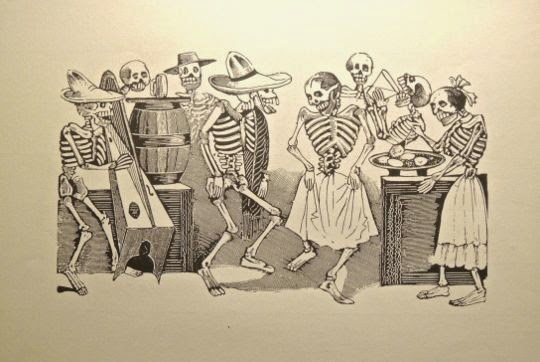
What they don't seem to notice is how much of the winnings are raked away by the out-of-view figure of the croupier, who represents the foreign bankers. This scene demonstrates both the profligacy of the nouveau riche and their fecklessness in allowing the nation's wealth to be increasingly dominated by foreign interests. They were caricatured in the late 19th Century by a political cartoonist named José Guadalupe Posada. He portrayed Mexico's nouveau riche as catrinas--skeletons elegantly dressed in the latest French finery. Posada was born and raised in Aguascalientes and his work is displayed in a local museum that I will show in a later posting. Catrina figures, and endless variations on their theme, are still wildly popular throughout Mexico. While the wealthy partied, the steam in that kettle began to whistle.


Revolution


Mexican generals assassinate revolutionary leaders Francisco Madero and José Piño Suarez. Madero is on the far left holding his Plan of San Luis Potosí and shaking the clawed hand of one of the treacherous officers. Piño Suarez stands behind him to the right. General Victoriano Huerta points a gun at the heads of Madero and Piño Suarez as other officers brandish knives. Francisco Madero ran against Diaz in the 1910 presidential election, while Piño Suarez ran for Governor of Yucatan. Both were arrested but escaped to the US. On November 20, 1910, they issued their Plan of San Luis Potosí. This called for widely popular land, labor, and election reforms. Pancho Villa, Emiliano Zapata, Venustiano Carranza, and many others answered the call. Diaz was quickly defeated and the old dictator resigned and sailed for France in May, 1911. Ironically, he would be the only top figure during the Revolution to die peacefully in bed. Madero and Piño Suarez were elected President and Vice President of Mexico. Though popular, Madero proved weak and a poor judge of character. He was an upper-class hacendado and, like many of the crillos during the Independence War, he wasn't really interested in the fundamental changes demanded by the workers and campesinos. Madero made the disastrous mistake of trusting Diaz' former generals. A group of them, led by Victoriano Huerta, conspired with US Ambassador Lane Wilson to stage a coup and set up a military dictatorship. During the coup, Madero and Piño Suarez were murdered in what became known as the Ten Tragic Days. Villa and Carranza joined with Zapata against Huerta. Zaparta was already in revolt because of Madero's failure to follow through on land reform.


Pancho Villa (left) and Emiliano Zapata (right) sit in front of their soldiers. Villa and Zapata possessed many similarities. Both grew up as poor country boys. Zapata lived on a small rancho and was an expert horse trainer. Even prior to Madero's 1910 proclamation, Zapata had begun to lead armed revolts against illegal land seizures in his native Morelos State. Villa grew up as a share-cropping campesino in Chihuahua far to the north. After a local hacendado raped his sister, Villa killed the man and rode off to the mountains to become a bandit. Both were close to the people and strongly supported land reform and an end to the hacienda system. Both were natural leaders beloved by their soldiers and, although lacking formal training, displayed great military ability. On the other hand, their personalities were quite different. Villa was ebullient and outgoing, while Zapata was intense and introspective. Of the two, Zapata had the most comprehensive and well-thought-out program of social reform called the Plan of Ayala, which he implemented even while the fighting continued. Villa seems to have been more of a "throw it up against the wall and see if it sticks" kind of guy. There is no doubt that they were the two foremost social revolutionaries in the struggle. They only met a few times and both came to tragic ends. Most in Mexico still consider them heroes.


Revolutionary leaders gathered in Aguascalientes in October 1914 to draft a constitution.  The fight to overthrow the usurper Huerta was the last time the leaders of the Revoluiton would all be on the same side. Zapata surged up from the south and Villa, under the command of Carranza, drove south. However, friction was already growing between Villa on the one side, and Carranza and his chief supporter Álvaro Obregon on the other. Defying Carranza's orders, Villa seized the vital silver-production center of Zacatecas. This broke the back of Huerta's resistance and, in July 1914, Huerta fled the country. He later died in a US jail. The revolutionaries agreed to meet in Aguascalientes to hammer out a constitution. They gathered at the Morelos Theatre, just off Plaza de la Patria. Although each sent delegations, none of the top leaders personally attended except Álvaro Obregon. Jealousy and distrust among them were increasing.


In an apocryphal scene, Zapata, Villa, and other leaders sign a Mexican flag. One of the most powerful convention speakers was Paulino Martinez, a member of Zapata's delegation. He demanded that the convention address "the social question," urging "land, liberty, and justice" rather than "presidential armchairs for those of ambition, wealth, and authority." He objected to "privileges for a particular group without political equality, collective welfare, and land for all." The revolutionary leaders attending included many who were, indeed, men of ambition. They recognised that they could only realise those ambitions by listening to the demands of the workers and campesinos who made up the bulk of their armies. Competing proposals for land reform and worker rights were soon developed by Carranza and Villa (Zapata was already implementing his Plan of Ayala). However, the failure of any of the Big Three to attend crippled the effectiveness of the convention. Through their delegations, Villa and Zapata agreed to support General Eulalio Gutiérrez Ortiz as interim President, but Carranza and Obregon refused. The third stage of the revolution was about to begin. Before its echoes faded, all four of these leaders would be dead from assassins' bullets.


Children surround a teacher who holds up Article 3 of the 1917 Constitution. Among other things, this article provides that elementary education shall be compulsory, that all education provided by the State shall be free, and that religious instruction in public schools is forbidden. That was truly revolutionary in Mexico. From the earliest colonial times, education had been denominated by the Catholic Church. Curbing the overwhelming social and economic control by the Church over national life had been the aim of reformers back to the days of Benito Juarez and his Reform Laws.


Scientists, philosophers and educators oversee the education of young children. Interestingly, what the children are viewing on the TV is Centeotl, the Aztec corn god. However much modern ideas spread in Mexico, ancient ways persist. The education provisions of the Constitution, and the policies they set in motion, arguably caused as much of a social earthquake as the breakup of the haciendas and distribution of their lands to the landless. The government sent thousands of low-paid teachers out into the hinterlands and initiated a policy of "each one teach one." This campaign began to dramatically reduce the illiteracy rate, at least at the basic level. As with land reform, there was bitter and sometimes violent resistance. Both the Church and the hacendados viewed the education campaign as a mechanism for undermining their traditional control over the rural population. Resistance to rural education was bitter and sometimes violent. As late as 1939, rural teachers were being murdered by Catholic fanatics.


Workers release doves of peace. The reforms of the Revolution didn't just distribute land and educate the illiterate. Maximum hours and minimum wages were set for workers, along with other reforms and protections. The right to organise was officially recognised and worker organisations proliferated. These not only enabled a united voice when dealing with employers, they provided a vehicle for worker and campesino political power. Mexico wasn't a "workers' paradise" after the Revolution, and certainly isn't today. Corruption is a problem and laws protecting workers are sometimes ignored. An expanding population has meant that the lands distributed in the 1920s-30s are no longer capable of supporting all those who might want to farm. The North American Free Trade Agreement has resulted in the dumping of tax-subsidised US agricultural surpluses, particularly corn, on the Mexican market. This has caused millions of small farmers to lose their land. Ironically, many have had to cross Mexico's northern border to work for the very agribusinesses that did the dumping. Still, with all of this, it would be hard to find any Mexican willing to go back to pre-Revolution times with no rights, no dignity, and little hope for change.

This completes Part 3 of my Aguascalientes series. I hope you enjoyed these wonderful murals and the story they tell. Anyone who wants to respond should either leave their comment in the Comments section below or email me directly. If it says "no comments" at the bottom of the page, that means no one has yet commented. Just click on that and it will take you to the Comments page.

If you leave a question in the Comments section, PLEASE leave your email address so I can respond.

Hasta luego, Jim

Aguascalientes Part 4: The Railroad Museum

$
0
0
An early 20th Century steam engine is displayed at Aguascaliente's Railroad Museum. The engine's nickname was "La Burrita" (the Little Burro). One of the many pleasant surprises during our short stay at Aguascalientes was a morning stroll from the Plaza de la Patria up Calle Francisco Madero to the Railroad Museum. Carole, who is not especially enamoured of mechanical things, was a bit dubious but willing to give it a go. The museum turned out to be a fascinating slice of the late 19th and early 20th Centuries. It will surely delight railroad aficionados, but there is plenty here to interest even the casual visitor. The museum is located at Parque Tres Centurias, about 10 blocks east of Plaza de la Patria. There was no charge when we visited.  For a Google map showing how to get there, click here.


Bronze statue of Cornelio Cerecero Terán, El Mechanista Elegante (The Elegant Engineer).  He was the last engineer who operated La Burrita which, in turn, was the railroad's last engine powered by steam. La Burrita traveled the rails until 1964 and was much in demand because of her power and reliability. Corneilio Cerecero Terán was famous not only because of his association with La Burrita, but because he was considered exceedingly handsome and well dressed, hence the nickname El Elegante. He is also remembered as a poet. I find it charmingly typical of Mexico that a rough-and-ready railroad engineer would write poetry in his spare time. In the great days of steam railroads, engineers were considered the elite of the working class. They were well-paid and they operated the largest and most complicated machinery of the time, outside of steam ships. The industry itself had transformed Mexico (and a good deal of the rest of the world) and was vital for the transportation of goods and people. Just as a youngster of today might dream of becoming a jet pilot or astronaut, young boys of that day dreamed of riding the rails at the helm of a great steam engine like La Burrita.


A line of boxcars stands beside the old platform. Some of the cars have been transformed into offices for the museum staff. This whole area used to be Aguascalientes' railroad station. The rail sidings, engines and various kinds of cars, baggage buildings, and the passenger station are now all part of the museum. In 1880, President Porfirio Diaz authorised the Bostonian Company to begin construction of a railroad between Mexico City and Ciudad Juarez. The first rails were laid in September 1880 and the line was finished in March of 1882. The first station in the State of Aguascalientes was established at the Hacienda Chicalote, about 14 km (8.7 mi) outside the City of Aguascalientes. The second station was built about 20 m (65.6 ft) from the museum's Passenger Station and was simply a shack built of laminated pasteboard. The land on which it was constructed was, at the time, part of Hacienda Ojocaliente. The old hacienda has since been swallowed up by the city.


The plush traveling car owned by the dictator Porfirio Díaz stands beside the baggage building. Rich and powerful people of the late 19th and early 20th Centuries traveled in cars like this. Owning such a car would be the equivalent to owning a private jet today. They were divided into sumptuous lounges, offices, and bedrooms so that their occupants could travel in the style they felt they deserved. For some reason the Diaz car was not open the day we visited, so I had to content myself with peeking in the windows. The glass reflections prevented any good photos of the interior.


Massive couplings connect one car with another. Looking at this, I recalled the movie "Unstoppable" with Denzel Washington and Chris Pine. During the film, the Chris Pine character accidentally gets his foot caught in just such a coupling and barely manages to avoid being run over by the train.  I enjoy trying to figure out how things work, so I puttered around examining the cars while Carole drifted through the rest of the area. In addition to the Railroad Museum, the Parque Tres Centurias contains large, shady gardens full of flowers and fountains. It is called the Three Centuries Park because elements of it reflect the 19th, 20th, and 21st Centuries.


A colorful caboose sits on a siding. These cars were for the crew and were attached at the end of a train. This one contained sleeping bunks, a pot-belly stove, cupboards for food, and space for off-duty crew to relax.


A hand car stands ready to go with the push of a lever. These little human-powered cars were used by track repair crews and other workers to cover short distances. Pushing down on the seesaw-like lever powers the car. One man could operate the car, but it would be much easier with two men, alternately pushing up and down on either end of the lever. A car just like this played a central role in the 1959 Gary Cooper movie "They Came to Cordura."


A statue of Julio Cerecero Terán stands holding a signal lantern while throwing a rail switch. Julio was El Elegante's brother and served as a member of his crew. A typical steam train had a crew of four, not including people like dining car staff, porters, and concessionaires. In addition to the engineer, they included the fireman who was responsible for operating the boiler that produced the steam. The conductor was in overall charge of the train and, in addition, handled passengers. The brakeman released the handbrakes on the cars, assisted the other crew and the passengers, and monitored the engine and cars. It appears from this statue that Julio may have been a brakeman.


La Burrita

La Burrita and El Mechanista Elegante stand frozen in time. Steam train engines were the technological marvels of their time. In the 21st Century, it is hard to comprehend a machine like this. Today everything seems to be driven by computers of various sizes and controlled by wireless signals sent through the ether, The steam engine above is completely mechanical and is driven by steam, a two hundred-year-old technology. While the stations would have been connected by telegraph, and eventually telephones, there was nothing electronic about this great beast of a machine. It represents the peak and, ironically, the endpoint of steam train technology.


Plaque fastened to the side of La Burrita's boiler.  She was manufactured in Schenectady, NY in December 1937 by the American Locomotive Company. There were only 12 like her in all of Mexico. Her main route was between Aguascalientes and Irapuato to the south.


The "business end" of the locomotive contains a bell and a cowcatcher.  Stencilled on the front, above the cowcatcher, are the words Seguridad Ante Todo (Safety Before All). The engine stands at least 4 meters (12+ ft) tall and everything about it seems massive. The number on the circular plate of the boiler is 2708 and it became a famous as La Burrita's designation. The brass bell mounted on the top of the boiler assisted, along with the whistle, in signalling and as a warning device.  The protruding cowcatcher at the bottom got its name as a device for protecting the front of the train from cattle that may have wandered onto the tracks, as well as other obstructions.


A cowcatcher, as used during the Revolution. This iconic photo from the Revolution shows four soldiers wearing broad sombreros. They are sitting on the cowcatcher, rifles at the ready. Next to them stands a mechanista, one of Cerecero Terán's predecessors. While this is a posed photograph, it is likely that in some cases soldiers rode in just this position to guard against obstructions or sabotage of the tracks. The soldiers were identified in the photo as followers of General Emiliano Zapata, known as Zapatistas. They carry a variety of weapons. The German Mauser on the left was probably captured from the Federal Army which used them extensively. The Winchester (far right ) was very common early in the war and may have been brought from home when the soldier signed up. Another revolutionary, General Pancho Villa, pioneered the large scale use of the Mexican train system to move troops. Since Aguascalientes was the hub of the national rail network in north-central Mexico, it became a key transit point--and strategic target--for various armies.


La Burrita's huge wheels drove her along the tracks. She was classified as a Hudson 4-6-4. This designation refers to the arrangement and size of the wheels. In front are two axels with 4 small wheels. They are followed by three more axels, seen above, with six big wheels. The big wheels are are attached to the levers which actually drive the train. Behind the big wheels are two more axels with four small wheels. Thus, 4-6-4. The system for designating trains like this was developed by Fredrick Methvan Whyte in the early 20th Century. The 4-6-4 arrangement was introduced in 1911 and continued to be manufactured until the 1940s. A engine using the 4-6-4 arrangement held the world speed record for steam trains in 1936, achieving a blazing 124.5 mph.


A brass train whistle juts forward from the top of the boiler. The whistle is attached to the steam dome, which provides dry steam to the cylinders for locomotion. Whistles were developed very early in steam train history as safety and signalling devices. In 1832, a stationmaster in England suggested some form of audible device after a train collided with a cart crossing the tracks. A local musical instrument maker was commissioned to construct what became known as a "steam trumpet." The whistles were blown as a warning when approaching crossings, and to provide various messages to railroad workers, a little like morse code. The size and construction of various whistles affected their sound, leading to nicknames such as "banshee" and "hooter." They were originally operated by pull cords or levers and could emit different sounds according to the style of the person operating them. Particular engineers could be identified by the way they blew their whistles. Sadly, all that originality disappeared when electronic methods of operation were introduced.


The cab of the engine was the point from which the train was controlled. The engineer and the fireman were stationed here throughout the journey. Early engines were followed by an open car full of wood and later coal. This fuel would be shovelled by the fireman into the mouth of the blazing compartment that heated the water and produced the steam. Later steam engines were fired by fuel oil that was piped into the fire compartment. No doubt the firemen were greatly relieved to avoid all that shovelling. Under the 2708 designation, you can see the notation "211 tons," the weight of the engine.


The Station

The Old Warehouse was where baggage and cargo were assembled for loading. Notice the old push-style baggage carts lined up next to the loading dock. This was one of the very first buildings of Aguascalientes to be built with cement. Although the city had been a way-station for travellers and silver caravans since the 16th Century, railroads put Aguascalientes on the map as never before. It was a natural hub for lines going north to Juarez (and from there into the US), south to Mexico City, east to the ports of Vera Cruz and Tampico on the Gulf, and west to Durango and the Pacific coast ports. Even today, the city enjoys a competitive advantage from its central position, although rail transport doesn't enjoy the monopoly it did in the face of competition from air transport and long-distance trucking.


Covered baggage carts line the edge of the Parque Tres Centurias' gardens. This version is covered against the weather and can be sealed against thieves. Apparently they were meant for baggage that needed to be held for later shipment. Interestingly, after reviewing scores of Google images of old railway carts, I could find none that resembled these.


This Passenger Station was begun in 1910 and finished in 1911. Built in California colonial style, it was the work of G. M. Buzzo, an Italian and cost 130 thousand pesos at the time. The structure was typical of railroad architecture of that era in that it was constructed using prefabricated materials. Notice the decorative designs just under the second story cornice. The front of the station is 52 m (170 ft) long, while the platform is 182 m (597 ft). The building has been beautifully restored, considering its age and the amount of traffic it saw.


The lobby of the Passenger Station contains comfortable benches and an elegant stairway. Displayed around the lobby are old photos and other objects from the glory days, including a collection of steam whistles of various kinds. The offices of the railroad officials were on the second floor. The overall impression is of spaciousness and a functional elegance.


The blackboard sign above announces Arrivals and Departures of Trains. Listed are the numbers of the trains and their routes. On the right, the times of arrivals (llega) and departures (sale) would have been chalked in after "H" for hora (hour). On April 18, 1915, General Pancho Villa arrived at the station with his army, following his defeat by General Álvaro Obregon at the Battle of Celaya. Villa had been badly beaten and was in a hurry to get back to his home base near Chihuahua. However, the army trains got tangled with the civilian ones. Villa was infuriated and summoned Central District Railway Superintendent Catarino Arreola Rochin. The General demanded that the Superintendent straighten out the mess within 24 hours or face the consequences. Maybe it just couldn't be done in that time, or perhaps the Superintendent was sympathetic to Villa's enemies. In any case, it wasn't done. Arreola Rochin was summoned once again before Villa and summarily executed by firing squad. One suspects that, given this incentive, the tangle was rapidly sorted out.


A mural in the Passenger Station shows railroad workers labouring under a Masonic Eye. The triangle with an eye and a half-circle sunburst under it is known as the Masonic Eye, but the symbolism goes back to the Middle Ages. The Masonic Lodges played an important political role in 19th Century Mexico, so it is not surprising that their symbol shows up here. Generally this painting can be interpreted to mean that the Eye of Providence (or of God) watches over the work of the railroad. The people in the painting are engaged in a variety of tasks. They carry loads, operate machinery, and study blueprints. This symbolises the fact that the railroad was a group project that required the skills of many and was not the product of any one person, however high up the scale he may have been.


Statue of a Mexican hero.Jesús Garcia Corona (1883-1907) was a brakeman on the rail line between the mining town of Nacozari, Sonora and Douglas, Arizona.  On November 7, 1907 he was resting at the Nacozari stop when he noticed that some hay piled on the roof of a rail car had been ignited by sparks from the engine's smokestack. This was alarming enough, but Garcia knew that the car was loaded with dynamite. Without a second thought, he leaped into the engine cab and put the train into reverse. He made it six miles out of town before the dynamite exploded. It destroyed the train and killed Garcia but the town and its population were saved. To honour his sacrifice, the town was renamed Nacozari de Garcia, the American Red Cross posthumously gave him the Hero of Humanity award, and a famous song was written about him.  R.I.P. Jesús.

This completes Part 4 of my Aguascalientes series. Even if you aren't a railroad buff, I hope you enjoyed the photos and stories above. If you have any comments, please either leave them in the Comments section below, or email me directly. If it says "no comments" below, it means that no one has yet commented. Just click on that and it will open the Comments page.

If you leave a question on the Comments page, PLEASE include your email address so I can respond.

Hasta luego, Jim


Aguascalientes Part 5: Templo San Antonio, an architectural jewel

$
0
0
Templo San Antonio is almost jewel-like in appearance. Begun by the Franciscans, the church later came under the control of the Augustinian Order. I considered combining this set of photos with those other sites but decided to let Templo San Antonio stand alone because it is so spectacular in architecture and in its interior decoration. When Carole and I stopped by here on our way back from the Railroad Museum, we were dazzled.  The church has been described as architecturally indefinable because it mixes the styles of Gothic, Neoclassical, Baroque, Moorish, and Russian. Another writer called it a perfect expression of the Porfirato, the 35-year dictatorship of Porfirio Diaz (1876-1911). That was Mexico's "Gilded Age," when lavish constructions like this could be financed out of the pockets of the wealthy elite.

The Temple's exterior

View of the Templo looking north along Calle General Ignacio Zaragoza. This area used to be full of orchards and was at the very edge of the city when it was originally laid out in the 17th Century. In the later years of the Porfirato, the city expanded and this site was chosen for the new church. The work on the Templo began October 22, 1895 and it received its official blessing in 1908, only two years before the start of the Revolution. The years of construction were the glory years of the Porfirato. In 2008, the church and the surrounding neighbourhood were refurbished for the 100th anniversary of its original opening. When we visited, the street was very attractive, with a border of potted plants and trees and a broad brick sidewalk.


Bronze statue of a man reading a newspaper. As we strolled along Calle Zaragoza, we encountered this fellow. Statues like this, seated on public benches, are popular in Mexico. It's all part of the country's quirky sense of humor. Often, I have seen a man sharing a bench with such a statue, apparently unaware that he was mimicking the activity portrayed by the artist. The style of wrought-iron furniture seen above is also universally popular. It can be found in the parks and plazas of the biggest cities and the smallest towns. Usually, the coat-of-arms of the municipality is displayed on the backrest of the bench.


Three towers decorate the roof of the Templo. The tallest tower is in the center and contains a clock which--surprisingly--shows the correct time. The exterior of the church was built with yellow cantera, which nicely picks up the glow of the morning sun. The stone was quarried in Cienega Grande, also located in the State of Aguascalientes. The electric lamps extending out from the onion-dome are among many which brilliantly illuminate the church at night. The small cupola on the very top contains a lantern. The only bells are those which hang in the central tower. They were imported from the United States. The Franciscans originally entrusted this project to the architect José Noriega, but he showed a lack of interest. They then turned to a young man named Refugio Reyes Rivas (1862-1945). This involved a considerable leap of faith because the new man was self-taught, held no formal degrees in architecture, and this was his first big project.


The huge dome was considered unsupportable and some authorities predicted disaster. The dome is reminiscent of St. Paul's Cathedral in London and is massive and immensely heavy. The engineer Camilo Pani predicted a collapse as soon as the scaffolding was removed. Young Refugio Reyes was confident in his calculations and methods of construction, He had good reason. Between the ages of 14 and 19 he had worked for the railroad in Zacatecas. The rail officials thought he was a promising young fellow and taught him how to calculate the strength of materials, a very important factor in building railroad bridges. It was also important for building churches, as it turned out. In the end, when the supports were removed, the building stood firm and the dome was unscathed. Lining the railing below the dome you can see a series of decorative stone urns. My architectural expert, Russel Versaci, tells me that these are called finials.


The Interier of the Templo

While the exterior is dramatic, the interior is truly spectacular. It seems that every inch of available space is covered with paintings, carvings, or other decorative arts. There is a sense of lushness here that definitely recalls the Gilded Age. Lining the walls on both sides of the nave are a series of large portraits of San Antonio (St. Anthony) painted by Candelario Rivas, one of Mexico's great religious muralists. They show San Antonio performing various of his many miracles. Each painting is contained within a circular frame, itself highly decorated.


San Antonio and the Miracle of the Mule.St. Anthony of Padua (1195 AD-1231 AD) was known as the Saint of Miracles because he is said to have performed so many. He was particularly compassionate toward heretics and greatly desired to convert them. The story goes that one heretic set him a test, saying he would convert if St. Anthony could get the man's mule to bow before the Eucharist. The heretic tried to rig the test, however, by starving the mule for three days and then tempting it with a bucket of food to distract it from the saint. The mule ignored the food and went to bow before St. Anthony who is shown holding the sacrament. The frame of the painting contains  leafy floral decorations and, at the top, a small face peers out. This is typical of the Baroque style.


San Antonio and the Christ Child behind the altar. The tall columns surrounding San Antonio are topped by Corinthian capitals and show a definite Neoclassical style. Anthony of Padua was born Fernando Martins de Bulhóes  in Lisbon, Portugal. His family was wealthy and sent him to study in the Cathedral school. That led to further studies with the Augustinians. However, Anthony found himself attracted to the simple life and evangelism of the Franciscans, an Order that had only just been established. He joined them and devoted himself to study and reflection. After he distinguished himself through his preaching, Anthony came to the attention of St. Francis of Assisi, the founder of the Franciscan Order. Francis assigned him the job of teaching promising new friars. His wonderful voice and deep understanding of the scriptures led to many speaking assignments over his brief life. After he died at 35, his tongue was preserved as a relic to commemorate his preaching gifts.


Above the altar is a stained glass window depicting the Crucifixion. Jesus is surrounded by a sunburst. Gathered about him are legions of angels and saints painted in postures of adoration. The cornices around the altar area are another example of Neoclassicism. During the first year of the Templo's construction, a funding crisis occurred. Into the breach stepped Antonio Morfin Vargas, a landowner and industrialist. His factories produced tobacco and cigarettes and he managed the profitable Hacienda La Cantera. All this made Morfin Vargas a very wealthy man. He picked up the $200,000 peso cost of the project, a very considerable sum in those days. A pious man, he felt his financing of Templo San Antonio was a way to give thanks for his good fortune. And, of course, he would have seen it as an excellent way to cement his place in Aguascalientes' society.


The interior of the dome shows the same intense level of decoration. The huge chandelier hanging from the dome seems a bit dwarfed by its surroundings. The Templo was officially blessed in a ceremony held December 8, 1908. During the ceremony, an odd and uncomfortable situation suddenly arose. The pews were packed with politicians, including the current and several former governors, the mayor of Aguascalientes and several members of the national legislature. All of them were members of the ruling Liberal Party. More than thirty years before, Benito Juarez and the Liberals had stripped the Mexican Church of much of its lands. This deeply angered Catholic officials who, at the time, controlled as much as half of the arable land in the nation. That same Party still ruled the nation under Porfirio Diaz. Although the Juarez era's anti-clericalism had been dropped, the lands had not been returned. Some in the Church felt they still had a rather large bone to pick with the Liberals. The politicians trapped in the pews cringed as the priest lashed out at Juarez and his Party for seizing those lucrative Church properties. Everyone pretended not to hear, but there must have been a lot of squirming in those seats.


Not only the walls, but the ceiling of the nave are covered by paintings and ornamentation. Light is provided by windows above the cornices and in back of the organ as well as from the large, multi-level chandeliers suspended from above. After the Blessing Ceremony, the Templo was celebrated in the press as a great achievement. Morfin Vargas was extolled for his role in bankrolling it. The unschooled Refugio Reyes was immediately established as a major figure for Aguascalientes' architectural future. However, even before the completion of Templo San Antonio, Refugio Reyes did not lack for work. As he was supervising work at the Templo, Reyes was also constructing another building for the Franciscans. Additionally, in 1902 he began work on Aguascalientes' Church of the Immaculate Conception. It was a work that broke with Catholic architectural tradition by not using a design where one nave crossed another with a dome in the center of the cross. Reyes seems to have been something of an iconoclast.


Detail from the ceiling of the nave.  Other work by Refugio Reyes includes the National Bank of Aguascalientes in 1905, and the Bank of Zacatecas in 1906. Also in 1906, he completed the towers of Aguascalientes' Sanctuary of Guadalupe and took steps to reinforce the Sanctuary, which had threatened to tip over on its side. In 1910 he built the Hotel Paris which is now the site of Aguascalientes' State Congress. These are only a few among the long list of the works through which this self-taught master left his mark upon Aguascalientes.


The loft in the rear of the nave contains the pipe organ. The ceiling above the organ is also packed with floral designs and religious scenes. The arches, except for the crosses contained in the series of small squares, show a Moorish influence. We left the Templo San Antonio somewhat overwhelmed by the experience. Anyone visiting Aguascalientes should make it a point to visit this remarkable church, created by an even more remarkable man.

This completes Part 5 of my Aguascalientes series. I hope you have enjoyed visiting this jewel of a church. If you would like to leave a comment, please use the Comments section below or send me an email. If you see "no comments" below, it just means no one before you has commented. Click on that and it will take you to the Comments page.

If you leave a question in the Comments section, PLEASE leave your email so I can respond.

Hasta luego, Jim

Aguascalientes Part 6a: The unique National Museum of Death

$
0
0
Beautifully wrought Aztec Eagle Warrior, depicted as a skeleton in the Museum of Death. Although created by a modern artist, ancient Eagle Warriors would have appreciated the image. The House of Eagles, their headquarters next to the Templo Mayor in Tenochtitlán (now Mexico City), was adorned with life-sized skeleton figures. The Eagle Warriors were the most important among the elite warrior cults of the highly-militarized Aztec society. The warrior above wields the fearsome machuahuitl, the basic Aztec hand weapon. It was a long, narrow wooden paddle with grooves along each edge containing razor-sharp obsidian blades. Against any of the Aztecs' pre-hispanic opponents, the machuahuitl was deadly. Against Spanish steel armour, it was relatively ineffective. The statue is displayed in Aguascalientes'Museo Nacional del Muerte. This museum is unique in Mexico in its focus on the complex and interesting way that Mexican culture views death. The Mexican views are radically different from those generally held by folks from "north of the border".


Museo Nacional de la Muerte

The National Museum of Death occupies what was once a 17th Century Convent. The museum opened in 2007 and contains more than 2000 artifacts, ranging from pre-hispanic to modern. Aguascalientes has a long history associated with skulls and skeletons. It is the birthplace of José Guadalupe Posada (1852-1913), creator of the famous catrinas, which have become wildly popular and are now found everywhere in Mexico. Catrinas are skeleton figures dressed in various costumes and portrayed in scenes of everyday life. The word comes from the Spanish term catrin, which refers to a dandy who imitates the lifestyles of the wealthy. In addition to Museo Nacional del Muerte's display of Posada's work, there is a separate museum in Aguascalientes devoted expressly to the work of this native son. Unfortunately we did not have time to visit the other museum.


The displays are contained in rooms surrounding this courtyard and its two-story atrium. Some of the walls behind the arched portales are covered with murals which I will show in a later posting. Posada became famous as a political cartoonist who satirically portrayed the affectations of Mexico's 19th Century nouveau riche. To do this, he drew skeletons wearing the latest European styles. Today, you can find catrinas shown as housewives, dentists, motorcyclists, golfers, and endless other  variations. I have even seen a catrina gynecologist examining a skeletal patient.


Death in the Pre-hispanic Era

A Colima Dog, found in a burial site of the Shaft Tomb Culture of Western Mexico. Ceramic dogs often appear in the burials of the Shaft Tomb Culture, especially in the area of Colima, Mexico. The culture gets its name from the unusual burial sites they created between 300 BC - 400 AD. These are found in a geographic area that follows a rough arc from Michoacan, up through Central Jalisco, and down to the coast of Nayarit. Shaft tombs were built with a vertical shaft as much as 20 m (65 ft) deep. At the bottom of the shaft, one or more bulb-like chambers were carved out of the soft volcanic soil. Bodies left in the chambers were sometimes arranged like the spokes of a wheel, with the feet at the hub. Large amounts of grave goods were buried with the bodies, and these are our primary source of information about the culture, since they typically did not build large above-ground structures such as pyramids or palaces. The grave goods often included several of the ceramic dogs, which are called Xoloitzcuintle. The nahuatl word is a reference to Xolotl, a dog-god who guards the dead and accompanies them on their journey through the nine levels of the underworld.


Teotihuacan skull inlaid with turquoise and obsidian. Teotihuacan was the greatest city of Mesoamerica, at least until the heyday of Tenochtitlan almost 1000 years later. The later cultures, including the Aztecs, held the ruins of Teotihuacan in awe, referring to them as the "Place where the gods were born." Between 100 BC and approximately 650 AD, Teotihuacan influence was pervasive in the area stretching between Guatemala and the Southwest United States. Turquoise, considered a sacred material, was mined in the Santa Fe, New Mexico area and traveled over long-distance trade routes to Teotihuacan. The ancient city was a multicultural capital, with neighbourhoods set aside for representatives of various groups, including the Zapotec kingdom of Monte Alban near present-day Oaxaca. The practice of decorating skulls with turquoise thus spread to the Zapotecs, and from them to the Mixtecs. After the Aztecs conquered the Mixtecs, they demanded skulls like this as tribute, and then adopted the practice themselves. While it is not clear what sacred purpose the Teotihuacans had in decorating skulls like this, the Aztecs used them in their worship of Tezcatlipoca, one of the most important gods in their pantheon. He represented (among many things) rulership, war, jaguars, the night sky, and hurricanes.


Tzompantli, or skull rack. These can be found widely in ancient sites, from Tollan, the capital of the Toltecs (north of Mexico City), to Chichen Itza, the great Maya city in northern Yucatan. Great copycats that they were, the Aztecs built a tzompantli next to the Templo Mayor of Tenochtitlan. Above you see a stone representation of the actual wooden racks on which hundreds of skulls were impaled on long horizontal poles. The tzompantlis in Tollan and Chichen Itza stand next to ball courts. The Mesoamerican Ball Game is strongly associated with human sacrifice. Aside from whatever religious significance the tzompantlis had, they were clearly intended to display power and achieve intimidation.


Mask of the Three Ages. This complex terracotta work by an Aztec artist portrays the three ages of life: youth, old age, and death/rebirth. Along with most Mesoamerican cultures, the Aztecs viewed the world--and life itself--as a succession of cycles. They believed that death is simply a transition point, a bit like Alice stepping through the Looking Glass. These ancient peoples closely observed nature and saw cyclical patterns in the seasons and in the movements of the heavens. They developed a complex system of mathematics in order to calibrate these changes accurately and thus predict the future. This had practical functions, such as determining the correct dates for planting and harvesting, as well as ritual and mystical purposes. The Maya developed the abstract concept of zero at a time when Europeans were still living in mud huts and wearing bear skins. Their long-count calendar system was so sophisticated that it could accurately specify a particular day millions of years in the past or future.


Zapotec funeral urn. This clay piece was unearthed in San Jose del Mogote, Oaxaca, and is from the late Pre-classic Era (400 BC - 100 AD). The elaborate head dress is typical of Zapotec sculpture. They left tombs in and around their mountaintop capital of Monte Alban that were filled with beautiful sculptures such as this, as well as exquisite jewelry. The Mixtecs, who later took over the area, often re-used the Zapotec tombs for their own burials. There is disagreement among archaeologists about whether the figures represent deities or actual rulers. There is also uncertainty about the function of the urns, since the Zapotecs didn't cremate their dead. Most have been found empty although one was full of bird bones.


Death and Cosmic Duality


Expressions of cosmic duality. The Mexican culture is strongly influenced by the thousands of years in which sophisticated societies existed here prior to the Spanish arrival. One way in which this is expressed is the concept of duality. According to Ricardo Valenzuela Ruiz, "There is a ceaseless, cyclical oscillation of polar yet complementary opposites. Duality takes the form of an endless opposition of contrary yet mutually interdependent and mutually complementary polarities which divide, alternately dominate, and explain the diversity, movement, and momentary arrangement of the universe." The statues displayed above express this duality in a variety of ways, but primarily through the juxtaposition of life and death.


A partly skeletal baby with Olmec features. The forms in which duality appears are endless, but life and death are very common expressions. The concept of duality is of one of an integrated whole rather than two separate and independent halves. Life cannot exist except in its relation to eventual death. Similarly, the masculine and feminine are two parts of a whole and, when united in the act of sex, may actually create life in the process. The concept of wet cannot be understood without also understanding its duality of dry. The same is true with hot and cold, light and dark, etc. The halves of each duality are interdependent and complementary.


Duality is expressed here as a double-headed figure. Not only does the skull head share a body with the living one, but the living figure is female and the skull half is male, yet another duality. They share the same painted designs on their body, which expresses a unity.  The two halves of the dual figure jointly caress a serpent. Snakes have been very powerful symbols all the way back to the Olmecs, the earliest Mesoamerican civilisation. Snakes are often depicted with two heads in the ancient art, or with a human form emerging from the snake's mouth.


Half human skull, half jaguar, this sculpture is still another expression of duality. Like the snake, the jaguar is another powerful and very pervasive symbolic figure. It is the third largest of all big cats, behind only the African lion and the Indian tiger. The jaguar is a powerful and stealthy hunter that stalks its prey in the night. Its nocturnal behaviour was believed to give it a strong connection with the underworld. In fact, the jaguar was believed to pass freely between the worlds of life and death. It is no wonder that various Mesoamerican royalty and warrior cults wore jaguar masks and skins to emulate this extraordinary creature.

This completes Part 6a of my series on the Museo Nacional del Muerte. I will do two additional postings on the museum. In the next, we'll take a look at the humorous aspects of death, from the Mexican point of view, and see some startling examples of the skull as an object of art. The last museum post will show some of the work of José Guadalupe Posada, the creator of the famous skeleton figures called Catrinas.  I hope you will enjoy this series within my Aguascalientes series. If you would like to leave a comment, please do so either by emailing me directly or by leaving your remarks in the Comments section below.

If you leave a question in the Comments section, PLEASE leave your email address so I can respond.

Hasta luego, Jim


Aguascalientes Part 6b: Laughing at death in Museo de la Muerte

$
0
0
Monsters on parade. How'd you like to answer a knock on your door and find these characters, arm-in-arm and reeking of tequila, asking you "where's the party?" I had to chuckle when I came across this little tableau in Aguascalientes' Museum of Death. There's so much going on with this group that it's hard to know where to look first. The central devil-figure is horrific enough, but why are his hands gripped in the teeth of flaming-eyed critters on either side. For that matter, why are those critters literally crawling with snakes and lizards of various sorts and sizes. There's something so cheery about this group that it's hard to be scared of any of them. A lot of the material in the museum is very funny, which goes to the heart of Mexico's relationship with death. It is a part of life and not something to be unduly feared, but instead appreciated and even mocked.


"OMG!!" I dubbed this unnamed figure the "Oh, my god!" statue. The expression of astonishment, consternation, and dismay expressed by this skeletal figure can be understood immediately by anyone. While this is a modern creation, similar expressions can be found on clay figures from the Shaft Tomb Culture dating back to 300 BC.


The dead like to party too! Grinning skeletons crowd around an overflowing banquet table. Food, drink, and a festive atmosphere are a part of Mexico's traditional Dia de los Muertos (Day of the Dead) fiesta each November 2. It's hard to be solemn or gloomy when all about you are enjoying themselves so much.


Music and dancing are also part of the scene. This pottery ensemble contains a number of skeleton couples dancing wildly. I could almost hear the mariachi music and the raucous laughter. The sculptor has captured the joyous motion of the dancers perfectly.


A day at the amusement park for the skeleton family's kids. The figures throw their hands out, just as living people do on an exciting amusement park ride. This child's toy functions by turning the crank at the side.


My attention was caught by this large, rather goofy mask. The tongue drapes down while the bugged-out eyes stare in wonder. Above the eyes, the toothy jaws of a grinning skull adorn the forehead.


The skeleton family that moulders together, stays together. This is another vignette where there's a lot going on. The central figure is the father, who clutches a scythe, always Death's hand-tool-of-choice. A baby skeleton hangs against his bare ribs, its arms around his neck. Meanwhile the father keeps a protective hand on the shoulder of a boy who seems about to run off to play. Accompanying the boy is a skeletal dog, looking equally ready for a romp. Another adult figure stands to the left of the father, also holding a scythe. This may or may not be the mother. The figure's head droops, perhaps drunkenly, while its arm is thrown over the father's shoulder. The hand clutches a bottle. The father's face is turned away. Is he expressing disapproval of his drunken companion, or is he hungrily looking at the bottle? You decide.


A Tree of Life inhabited by skeletal musicians. Perhaps these are the guys playing for the dancers seen previously. The instruments appear to be mainly brass and drums. Tree of Life sculptures began appearing shortly after the conquest. They were used to evangelise the indigenous people by telling biblical stories. By the 20th Century, Trees of Life were appearing that bore no relationship to religion. However, this one contains a figure at the bottom center who may be an angel wearing a hat decorated with a cross.


The skull as a medium of art

A ceramic skull is decorated with painted flowers and other designs. As you saw in my last posting, people have been using skulls as decorative mediums since at least the era of Teotihuacan (100 BC - 650 AD) and perhaps even earlier. This is a modern creation, but the elongated skull seems to hark back to the Maya practice of deliberately deforming the skulls of infants to mark them as members of the nobility.


Another flowered skull wears a toothy grin. This pottery skull has been beautifully painted. The sign indicates Patzcuaro as its place of origin. Patzcuaro is famous for its Day of the Dead fiestas.


A surreal example of skull decoration. The colours of this red, green and white pottery creation are those of the Mexican flag. This guy looks like he just won the lottery, or watched his mother-in-law fall headfirst into a mud puddle.


An actual skull, with its eyesight returned. The sculptor has achieved a startling result by taking a real skull and filling in the eye sockets with flesh-toned plaster and wide-open eyes. The eyelashes enhance the effect. I half expected the skull to say something cheery as I went by.


A hooded gremlin protectively hugs a large skull. He seems to be saying "it's mine, all mine!" As you can see from the above examples, humor forms a large part of the Mexican attitude toward death. It seems to me that this is a much healthier frame of mind than the north-of-the-border tendency to look upon it all as depressing.

This concludes Part 6b of my series on Aguascalientes. Next week we'll take a look at José Guadalupe Posada and his famous catrinas. I'll show a number of examples of his 19th and early 20th Century engravings that satirised Mexican society of the time. I hope you have enjoyed this posting. If so, feel free to comment either in the Comments section below or by emailing me directly.

If you leave a question in the Comments section, PLEASE leave your email address so I can respond.

Hasta luego, Jim

Aguascalientes Part 6c: José Guadalupe Posada's satirical 19th Century catrinas and their 21st Century descendants

$
0
0
A classic catrina of the 19th Century. The term catrina is the feminine version of the Spanish word catrin, which means dandy, dude, or toff. The catrina shown above was one of the earliest creations José Guadalupe Posada (1852-1913), who invented the genre. The figure satirizes the sartorial pretensions of Mexico's wealthy classes toward the end of the 19th Century. This period was called the Porfirato, after Porfirio Diaz who ruled Mexico with an iron fist from 1876 until he was overthrown by the 1910 Revolution. The feathered hat represents the newest French style of the time and Posada uses it to depict the fixation of the rich upon all things European, especially French. This catrina, and many more, were on display in Aguascalientes' National Museum of Death when we visited the city.


A catrin struts along, displaying the pride and arrogance of the Porfirato era's wealthy. A stylish sombrero tops the calavera (skull or skeleton), which clenches a huge cigar between its jaws. The catrin also sports a diamond stickpin in its cravat, a flower in its lapel, and a cane or walking stick similar to those favored by "men of substance." José Guadalupe Posada is one of Aguascalientes' most famous sons. He came from a modest background and learned reading, writing, and drawing from his older brother Cirilo, a teacher at a country school. At the age of 16, Posada went to work for a local printer named Trinidad Pedrozo. From Pedrozo, he learned lithography and engraving.


A stylish couple, out for a walk in the park. In his later years, Posada worked with another illustrator, Manual Manilla, and they shared the catrina theme. Because they worked so closely together, it is sometimes difficult to tell their work apart. However, I believe the cartoon above may be one of Manilla's works. Posada's career as a political cartoonist began in 1871 when he took a job with an Aguascalientes newspaper called El Jicote (The Bumblebee). The young cartoonist's satirical illustrations apparently carried quite a sting because the paper lasted a mere 11 issues. Both Posada and the publisher had to flee the city after someone very powerful took exception to an El Jicote cartoon.


Partying at the cantina. Here, Posada depicts common people engaged in a favorite activity. Two of them dance to the music of a harp played by the calavera on the left. Originating in Vera Cruz, this style of harp is still popular with street musicians. Other skeletal figures watch the dancing couple while one on the right downs the contents of a large pitcher. He may be imbibingpulque, an alcoholic drink made from the heart of the maguey plant. This beverage has been popular among the rural poor since early pre-hispanic times. Although pulque can still be found at roadside stands, in modern times it has largely been supplanted by beer.


Dressed as a hacendado and wearing a broad sombrero, a catrin enjoys a drink. In another of Manilla's illustrations, a hacendado (hacienda owner) raises his glass of fiery tequila, his wife (girlfriend?) peeps over his shoulder. Traditionally, this drink would be followed by a quick suck on a fresh lime and a lick of salt sprinkled on the back of the hand. On the table are a lime and a knife to cut it. Notice the cork on the left side, labeled "Tapatio." This is the nickname for a resident of Guadalajara and was also apparently the name of a brand of Tequila at the time.


Catrinas and violence

A catrin on a rampage. Campesinos flee in all directions as the knife-wielding catrin tramples skulls underfoot. There were quite a number of violent images displayed among the Posada collection. Here, the cartoonist appears to be portraying the dark side of Mexico's wealthy class. After fleeing Aguascalientes, Posada settled in Leon, a city in the neighbouring state of Guanajuato. Apparently his powerful enemy could not reach him there. Rather than cowing him, the initial response to his cartoons appears to have inspired him as an illustrator. Posada took various free-lance jobs in Leon, including more political cartoons but also a lot of commercial illustrations for magazines and book covers. He even began teaching lithography at a local school. Again, disaster intervened, this time from nature. A massive flood inundated Leon, forcing Posada to flee to Mexico City.


Violence was also common among ordinary people in Posada's day. Possibly as the result of a drunken brawl at a cantina, one campesinocalavera prepares to slash another with a razor-sharp sickle. The clothing and straw sombreros of the figures are very typical of those worn by the rural poor of Posada's day. After arriving in Mexico City, he set up his own lithography and engraving shop, but also took free-lance work from publishers around the city. The most important of these was Antonio Vanegas Arroyo. Posada forged a long-standing association with Arroyo during which they published huge numbers one-page broadsheets called hojas volantes (flying leaves). These contained stories, high-society gossip, or popular songs and were enlivened by Posada's illustrations. The hojas volantes turned out to be wildly popular. During this period, Posada increasingly used his catrinas to draw attention to the gross social injustices of the Porfirato.


A mounted Mexican lancer tramples other calaveras in a wild charge. Porfirio Diaz had been an officer and hero during both the Reform War of the 1850s and the French occupation that followed it in the 1860s. He rode his popularity to the presidency in 1876. Thereafter, he used the Mexican army to crush revolts, break union strikes, and generally suppress social unrest. Posada's calavera images carried multiple levels of meaning and were very powerful in a largely illiterate society. Even the poorest peon could immediately understand them. The use of skeletal figures was a reminder that everyone is equal in death. Regardless of social position or economic status, no one is spared.


Even in Hell, the calaveras continue to party. As the flames of the hereafter rise among them, the skeletal figures drink, carouse, and even play the base fiddle. Posada, along with his fellow illustrator Manilla, produced tens of thousands of illustrations utilising catrinas. About 2000 of them survive in various collections in Mexico and around the world. Posada's work was not only influential in highlighting the social inequities of his day, but it also had a deep impact on the future of Latin American art.  Mexico's two greatest muralists were Diego Rivera and José Clemente Orozco. In their youth, both visited Posada's shop to watch him work. Both credit him with deeply influencing their art. In one of his greatest paintings, "Dream of a Sunday Afternoon in Alameda Park," Rivera prominently features a catrina in the center of the crowd. Orozco said that his visits to Posada's shop resulted in "my awakening to the existence of the art of painting." Many other artists throughout Latin America were also touched by the cartoonist's genius. In the end, however, Posada died in poverty and obscurity in 1913.


Modern Catrinas

A catrina as a bride, waiting for her groom. This beautifully detailed ceramic figure uses a theme that is fairly common. During a Day of the Dead fiesta a couple of years ago, I visited some of the local, front-yard altars created for the event. One of them contained a "living tableau" where a young woman had made up her face like a skull and wore a bride's gown. The sign she carried that said "Busco novio" (I search for a boyfriend).


Poking fun at the Church.  A bishop in his vestments raises a hand to bless the faithful. The upper hierarchy of the Mexican Catholic Church has been closely associated with the wealthy ruling elite since the earliest colonial times. As an institution, the Church benefited greatly from the exploitation of poor mestizo and indigenous people, and used their forced labor to build some of the great religious edifices. The Church even owned large haciendas where the peones (workers) were whipped for attempting to run away, or even just failing to attend religious services. Consequently, a deep strain of anti-clericalism runs through this overwhelmingly Catholic country. Satirical creations like the one above are one way in which this feeling is expressed.


A bony ballerina twirls on her toes. We found this life-sized figure under the arcade that surrounds all four sides of the central courtyard. She was one of several that were engaged in various activities.


Is this the missing groom? Dressed in his 19th Century finest, this top-hatted figure could have paired up with the bride in the initial photo of this posting. However, they were made by different artists. He is quite a slim and handsome fellow though.


 Woman on a swing. This tableau caught my eye as we walked along the arcade corridor. Somewhere in the back of my mind, I remembered a painting that looked remarkably like this calavera on a swing. I think I found it here.


A touching family scene. Entitled "Calavera Family," this little piece shows a husband, wife, and child seated spoon-fashion with their arms around one another. The fact that they are skeletons doesn't detract from the feeling of affection and togetherness.


Murals of the Death Museum

A soldadera cradles a skull while sitting in a spooky graveyard. Surrounding the second floor of the Museum's atrium there is another arcade. A section of the wall is covered by large murals relating to the theme of death. In the scene above, a young woman sits on one of the raised tombs typical of Mexican graveyards. She is dressed as a soldadera (female soldier of the Revolution) complete with a bullet bandolier across one shoulder. In the crook of her arm, she cradles a turquoise-inlaid skull, similar to those in the Museum's displays from ancient Teotihuacan and the Aztec Empire. She appears to be conversing with it. Behind her stands Coatlicue ("Mother of the gods"). The original of this statue is contained in Mexico City's National Museum of Anthropology. It is more than 3 m (10 ft) tall, weighs several tons, and is truly awesome to behold.


At the foot of another tomb sit three cheerful little gremlins. These calaveras have obviously been partying very heartily. While the one on the right stuns his guitar, the gremlin in middle points his pistol at the night sky. The figure on the left laughs as he clutches a bottle.


On another panel, a young woman covers her face in despair. She holds a photograph of a young man, possibly a relative or boyfriend. The photo is spattered with blood, indicating the young man met a violent end. A wrecked, burned-out pick-up truck stands in the background. This scene is certainly suggestive of the more than 60,000 people who have died in Mexico's seemingly endless drug war.


A narcotrafficante sits across from the young woman, watching her with an evil look. Dressed in a black leather suit, his posture is a near-parody of Rodin's famous statue "The Thinker." Behind him a vehicle burns fiercely. Perhaps he is responsible for what happened to the man in the blood-spattered photo. Even though scores of thousands have died in the conflict, it directly touches the foreign community only rarely. Still, Mexicans that we know have lost friends and relatives to this kind of violence. Unfortunately for Mexico, the US has an insatiable appetite for illegal drugs. It also has a bottomless supply of the weapons favored by the cartels. As a Mexican leader once said about a different conflict: "Poor Mexico, so far from God, so close to the United States."

This completes Part 6c of my series on Aguascalientes. If you have enjoyed it, you are welcome to leave a comment either by using the Comments section below or by emailing me directly. If it says "no comments" below, it just means no one has left one before you. Click on that and it will take you to the Comments page.

If you leave a question in the Comments section, PLEASE leave your email address so I can respond.


Aguascalientes Part 7: San Marcos' statue garden and lovely Templo

$
0
0
Statue of a flower girl in Jardin de San Marcos. This charming, life-sized, bronze sculpture greets visitors who enter the lovely Garden of San Marcos from the east end. You can find the Jardin by walking west on Calle Venustiano Carranza from the Plaza de la Patria. The Templo San Marcos stands at the west end of the Jardin. Together, they form the center of the Barrio de San Marcos, one of Aguascalientes' oldest neighbourhoods. The typical layout of Spanish colonial cities follows a pattern of concentric circles. The center was for the pure-blood Spanish, and contained the main plaza, the most important church, government buildings, and mansions of the wealthy and powerful. The next ring of the circle was for people of lesser wealth and power, such as soldiers, bureaucratic functionaries, and merchants. Many of these were mestizo or of mixed blood. The outer ring would be occupied by the indigenous people. They were the labourers and craftsmen who built and maintained those churches, government palaces, and mansions. Barrio de San Marcos was one of those early, outer-ring neighbourhoods. You can find the Jardin de San Marcos by clicking here.


Jardin de San Marcos

A massive gate guards the west end of the Jardin. The gate and the beautiful balustrade were built with pink cantera, a plentiful local stone often used for decorative work. The balustrade completely surrounds the Jardin. The whole park occupies a rectangular area of 168 m by 88 m (551 x 288 ft). It has a gate on each side corresponding to the four cardinal directions. When the Barrio de San Marcos was settled in 1604, it was actually a separate village from the city of Aguascalientes. The first residents were from Tlaxcala, the former indigenous kingdom to the east of Mexico City. It was one of Hernán Cortés' earliest and most faithful allies in the struggle to conquer the empire of the Mexicas (Aztecs). Thousands of Tlaxcalans marched in the conquistador armies. The Conquest could not have happened without them. It is likely that the Tlaxcalans ended up in San Marcos as a detachment of mercenaries to help defend against attacks by theChichimec nomads on Aguascalientes during most of the 16th and 17th Centuries. Four hundred forty-two people settled down in the new pueblo of San Marcos and were granted self-governing authority by the Spanish Audiencia (ruling council) in Guadalajara.


A jewel-like 19th Century kiosco sits at the center of the Jardin. Paths radiate out from the kiosco (bandstand) to the four park entrances. The Jardin is a great place to stroll or just relax on a shady bench. The boundaries of the City of Aguascalientes eventually expanded to incorporate the pueblo of San Marcos, although the barrio maintained its own traditions. However, it lacked the central plaza that is vital to every Mexican community, so the residents applied to the city for permission and land to build one. In 1842, permission was finally granted and the land set aside. That same year the neoclassical balustrades surrounding the Jardin were built and the State Governor Nicolas Condelle officially opened it, although the first phase of building actually lasted until 1847. Forty years later, in 1887, four fountains were added, one for each corner, along with the wrought-iron benches. In 1891, the jewel-like kiosco was placed in the center, and the basic outlines of the Jardin were complete.


Two older gentlemen chat on a bench next to a vendor's booth. I love Mexican plazas with their bright flowers and cool, shady walkways. Always, there are wrought-iron benches for the weary or those who just want to while away the hours of a warm afternoon. These two appear to be old friends and may have been meeting on this same bench for decades.


Two other gentlemen, also chatting on a bench.  The work is entitled "La Banca de los Pájaros Caídos" (The Bench of the Fallen Birds). These two wear clothes from the 19th / early 20th Century era. The man on the right probably works at the railroad complex at the other end of town. This sculpture and a variety of others were installed in the Jardin in 2009. They were part of a major refurbishment of the park in preparation for the 434th anniversary of the founding of Aguascalientes. You can clearly see the quirky Mexican sense of humour in works like this. In fact, I have found bench-sitting bronze statues all over Mexico. It seems to be a popular theme.


A sculptor carved and painted a tree to represent the pre-hispanic god Quetzalcoatl. Raul Jorge Tapia Morquecho completed this sculpture in the autumn of 2011. The title is Quetzalcoatl, El Sexto Sol (Plumed Serpent of the 6th Sun). It was carved from a 70-year old Ash tree. The sculpture demonstrates the pre-hispanic concept of duality, with the green feathers representing the quetzal bird and the golden scales representing the coatl (serpent). In addition, the work celebrates the four basic elements of nature: earth, fire, wind and air.


Another bronze work, entitled "El Sereno." Wrapped in his serape and topped with a broad sombrero, El Sereno (The Night Watchman). calls out the time and assures that "all is well".  Figures like this patrolled the night-shrouded streets of the city in bygone times to keep an eye out for fires, marauders, or other disturbances.


El Barrendero ensures the walkways are free of debris. In a jaunty top hat and three-piece suit, this skeletal figure entitled El Barrendero (the Sweeper) gives a nod to José Guadalupe Posada, Aguascalientes' famous inventor of catrinas.


A workman in the posture of a matador. I could find no title for this statue, but the worker is clearly meant to represent a matador. Dressed in overalls and armed with a screw driver for a sword, he appears ready to do battle with the Bulls of Industry.


Siesta time in the Jardin de San Marcos. A weary worker takes advantage of an empty bench to enjoy a siesta on a warm afternoon.


Templo de San Marcos

A broad paved plaza separates the west end of the Jardin from the Templo de San Marcos. In 1655, a more primitive chapel was built here. In 1733, Dr. Don Manuel Colon Larreategui, felt the community needed a grander church and laid the foundations for the present Templo. However, the church wasn't finally finished until 1765. The facade of the church was built in the Baroque style in three levels with niches for five saints. In the middle of the second level, between two of the saints, is a stained glass window with the image of the Virgen del Carmen. The small figure in front of the church is a local policeman.


To protect and serve. This little fellow differed considerably from the much larger and more beefy policemen I saw around Aguascalientes. He seemed amiable, but rather bored, as he wandered around the plaza in front of the Templo. He did possess a mustache that helped provide the gravitas he might lack from his short stature.


View of the Templo from the north side. The belfry tower rises in two levels above the roof of the church. The dome roof is covered by beautiful yellow tiles.

Flying Buttresses support the side walls. On each side of the church are two flying buttresses, a method of supporting high walls that was an important architectural development in the Middle Ages. The buttresses allow much thinner walls and large, stained glass windows. The outward pressure from the weight of the walls is transferred from the buttress against the wall to the outer or "flying" buttress by means of the slanting bridge that connects them. Although the concept was not fully developed until the 12th Century AD, a precursor to medieval flying buttresses is described in the Old Testament Book of Ezekiel.


The beautiful Baroque lines are somewhat marred by the ugly clock tower. This was obviously some bureaucrat's idea of an "improvement." I tend toward the philosophy of "if it ain't broke, don't fix it!"


The entrance is guarded by a pair of large, metal-sheathed doors. The coat-of-arms of the church is included in the design on the upper part of the door. Once inside the vestibule, you encounter an elaborately carved wooden barrier which shields the serene interior from the intrusion of exterior noises.


The face of the great entrance door. The surface is metal, pierced and studded by hundreds of pointed caps. This would certainly be a formidable barrier to anyone trying to force entry.

The interior of the church. There is a single long nave with a short alcove on either side. Together they form the traditional Latin Cross form of church architecture. At the far end is the main altar, covered overhead by the massive dome.


The pulpit. An elaborately carved pulpit is placed at the entrance of the alcove on the right. From this high point, a priest can exhort the faithful.

The main altar. In the niche at the center, the Virgen del Carmen is seen dressed in rich robes and holding the Christ Child. Above her, San Marcos stands in his own niche between neoclassic columns. The Virgen del Carmen is the patroness of the Carmelite Order, which originated on the slopes of Mt. Carmel in the Holy Land during the 12th Century. She is associated with a life a contemplation and prayer. San Marcos (St. Mark) is traditionally believed to be the author of the New Testament's Gospel of Mark. He founded a church in Alexandria and both the Coptic Christians and the Greek Orthodox Christians claim to be his successors.


San Geronimo and the lion between the arches supporting the dome. San Geronimo (St. Jerome) is one of the four Doctors of the Church. These were especially learned figures who made significant contributions to Church doctrine. During San Geronimo's life (347-420 AD) he spent considerable time in solitary contemplation in the Syrian desert. There, according to legend, he encountered a fierce lion which he tamed by pulling a thorn from its foot.


Interior of the dome. A chandelier hangs down from the center of the dome. In addition to San Geronimo in the upper left corner, paintings of the three other Doctors fill the triangular spaces at the corners of the arches.

This completes Part 7 of my Aguascalientes series and is the end of the series itself. Anyone who visits the city should take a stroll down to the Jardin and the Templo de San Marcos. It will be well worth your time. I hope you have enjoyed my posting and, if so, I encourage you to leave any thoughts you might have either in the Comments section below, or by emailing me directly.

If you leave a question in the Comments section, PLEASE leave your email address so I can respond.

Hasta luego, Jim


Viewing all 346 articles
Browse latest View live